
For most of the past decade, the geospatial industry has moved forward in predictable ways. Better sensors, more satellites, faster processing, and incremental improvements stacked on top of existing workflows.
2025 doesn’t fit that pattern.
This year felt different. Not because of a single breakthrough, but because several pressures arrived at once. Changing geopolitical landscape reshaped how digital infrastructure is viewed. Economics forced hard conversations in Earth Observation. Expectations around accountability were rising. And artificial intelligence is beginning to reason across spatial context rather than simply process it.
Taken together, these shifts point to a year of structural realignment for the geospatial industry.
The AI Moment Arrives for Geospatial
AI isn’t new to geospatial. What changes in 2025 is where generative AI begins to enter core geospatial workflows, and how that alters the shape of everyday work.
For years, geospatial AI focused on narrow, task-specific models: classification, detection, segmentation, and feature extraction. Those capabilities remain central. But in 2025, large language models and multimodal systems start to appear higher up the workflow, interacting across imagery, vector data, documents, 3D, and sensor streams rather than being applied only at the end of the pipeline.
That shift changes expectations. Instead of models designed to answer a single question well, systems are increasingly expected to operate across context: linking datasets, surfacing relationships, and supporting interaction through natural language. The emphasis is less on new analytics and more on orchestration—connecting outputs and reducing friction between steps that were previously manual.
The change is visible in how major technology players are approaching Earth observation. Google has moved beyond treating geospatial data primarily as something to visualize or label, investing instead in model-driven representations of the planet that fuse satellite imagery, environmental variables, and long time series to support reasoning about change at scale.
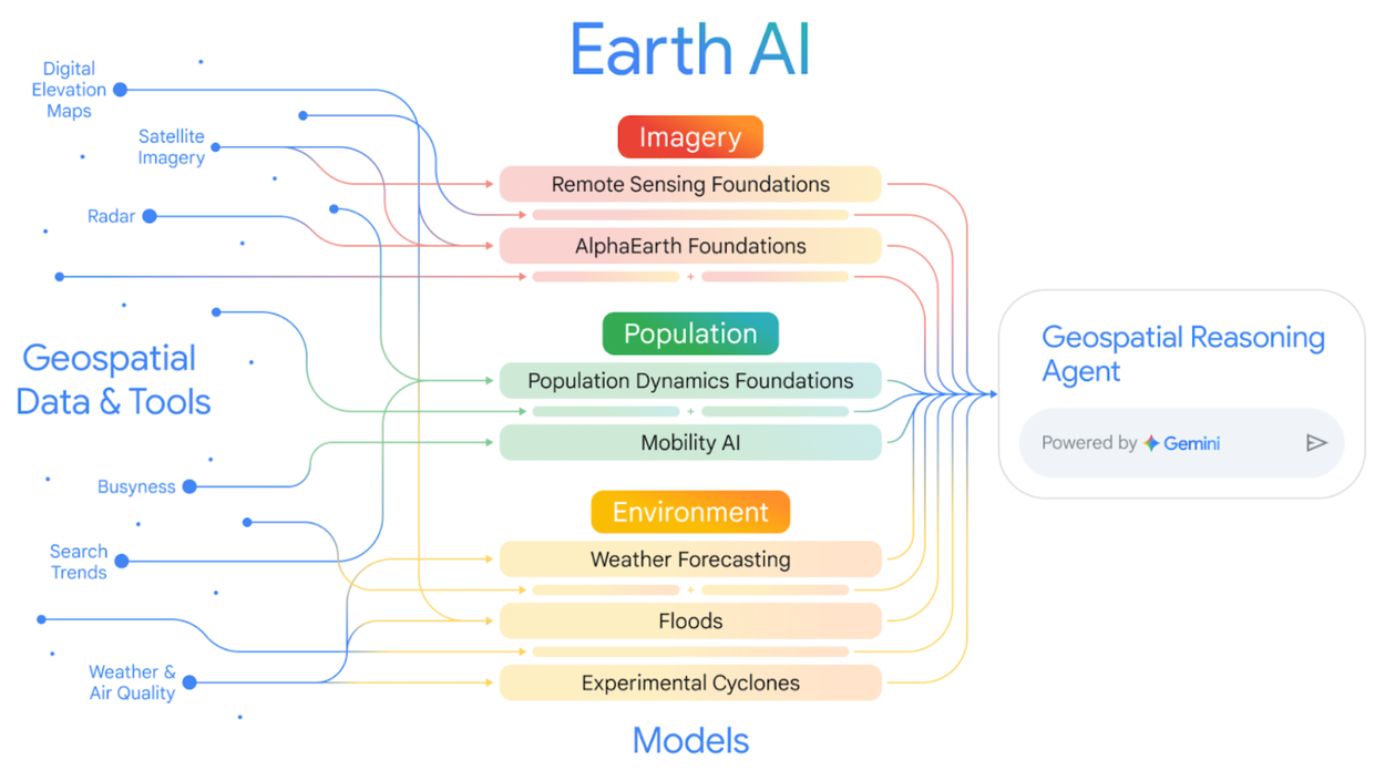
Microsoft has taken a different route. Rather than building standalone geospatial AI platforms, it is embedding large language models into cloud-based mapping, analytics, and digital twin environments, making spatial data easier to interrogate and connect within existing enterprise workflows.
This shift is not limited to large organizations. A growing wave of startups and applied initiatives is experimenting with LLM-enabled workflows across Earth Observation, risk analytics, infrastructure monitoring, and environmental intelligence. One good example is the Taylor Geospatial Institute-AWS Generative AI for Geospatial Challenge, whose 2025 report highlighted how early-stage teams are using foundation models to support spatial analysis, monitoring, and decision-making, often by integrating generative AI into existing geospatial pipelines rather than replacing them.
In many cases, these efforts focus on how analysts interact with geospatial data rather than on replacing existing analytical methods. What stands out in 2025 is total reconfiguration of how AI fits into geospatial workflows.
Sovereign Digital Infrastructure Moves Into Execution
Sovereign digital infrastructure has been talked about for years. In 2025, it stops being abstract.
In the face of changing geopolitical alignments, across multiple countries, funding decisions, procurement language, and infrastructure planning are starting to reflect a shared concern: reliance on external systems for critical digital and spatial capabilities is no longer comfortable.
Geospatial sits right at the center of this. Cloud-hosted spatial data, mapping platforms, Earth Observation systems, and navigation signals underpin public services, infrastructure planning, climate monitoring, and emergency response. When those systems are treated purely as services, dependency feels manageable. When they are treated as infrastructure, the calculus changes.
Two things are happening in parallel.
First, governments are reassessing where geospatial data lives and how it is governed. This is not always about strict localization, but about continuity, resilience, and control. Spatial data is increasingly seen as part of the digital backbone, and not a technical add-on.
Second, those same concerns extend to Earth Observation itself. Assured access to space-based monitoring is no longer taken for granted. The 2025 ESA Ministerial made autonomous and dependable EO capacity an explicit priority. Canada, too, moved in this direction, committing $47 million to secure access to essential Canadian Earth Observation system. India announced a coordinated push to bring major private-sector players together around a national EO system.
Different countries, different approaches. But the logic is the same.
Geospatial infrastructure is being treated less like a market convenience and more like a strategic asset.
Earth Observation and the Reality of Asymmetric Markets
By 2025, the EO sector is being forced to confront an uncomfortable truth: not all demand is equal.
The most stable growth is coming from defense and dual-use applications – national security, intelligence, disaster response – where governments are willing to pay for continuity, resilience, and assured access. For many EO companies, these contracts now anchor revenues in ways purely commercial markets have not.
Outside that space, adoption is far less predictable. Climate and sustainability were widely expected to be the EO sector’s big enterprise growth engine. In practice, uptake has been uneven.
At the same time, questions around civilian EO continuity are becoming harder to ignore. In the United States, budget cuts at NASA and NOAA have sharpened concerns about the long-term stability of non-defense Earth Observation and environmental monitoring missions.
That uncertainty contrasts with signals coming from elsewhere. Commitments made at the 2025 ESA ministerial reinforce sustained public investment in Earth observation, with an explicit emphasis on resilience and dual-use capability. EO is increasingly framed not just as a civil or scientific asset, but as infrastructure that supports security, preparedness, and public-interest operations alongside commercial use.
Taken together, these signals help explain why EO demand in 2025 feels uneven. Growth is not disappearing, but it is concentrating around national priorities and public-interest use cases, rather than the broad, horizontal commercial expansion once assumed.
This is also the year geospatial foundation models begin to move from research into production environments. But adoption is still gated by interoperability, harmonization, and trust in outputs. The technology is ahead of the systems meant to absorb it.
Geospatial Becomes Evidence
The bar for environmental and risk claims is rising. In finance, insurance, supply chains, and public policy, explanations are starting to run out of road. Claims about land use, deforestation, water stress, biodiversity, or infrastructure exposure increasingly need to survive being checked and compared, not just described. That pressure exposes a basic limitation. Without stable spatial baselines and repeatable observation, many of these claims are difficult to assess with any confidence.
That’s why geospatial data is being pulled into a different role. It’s no longer just providing context around a decision; it’s being used to support the decision itself. Demand is shifting toward systems that can produce consistent, traceable measurements over time, rather than one-off analysis.
For instance, in Europe, this shift becomes operational in 2025. The EU’s Corporate Sustainability Reporting Directive now requires large companies to publish audited sustainability disclosures. Indicators linked to physical risk, land use, and environmental exposure increasingly need spatially consistent, traceable backing rather than narrative explanation alone. Voluntary frameworks are reinforcing the same pressure in practice. Early adopters working with guidance aligned to the Taskforce on Nature-related Financial Disclosures are discovering how difficult it is to assess ecosystem exposure and land-use risk without reliable geospatial baselines.
Taken together, these changes are altering what buyers expect from geospatial systems. The emphasis is moving toward defensible measurements and long-term consistency, rather than presentation or update frequency.
GNSS Reliability Becomes a Civilian Concern
GNSS has long been treated as invisible infrastructure with jamming and spoofing mostly confined to conflict zones. However, there are increasing reports of jamming and spoofing surfacing in civilian settings too.
Aviation authorities have been among the first to acknowledge the shift. The European Union Aviation Safety Agency has issued repeated advisories warning of GNSS interference affecting commercial flights, including incidents far beyond active conflict areas. Similarly, in the United States, concerns raised by civil agencies and industry groups point in the same direction: GPS disruption is increasingly being treated as a risk to civilian aviation and critical infrastructure, not a niche or defense-only issue.
Maritime authorities are reporting parallel impacts, with authorities documenting interference affecting civilian shipping, including false positioning and reduced confidence in electronic navigation systems.
Much of the recent escalation in jamming and spoofing has been observed in and around active conflict zones, particularly linked to electronic warfare activity associated with Russia.
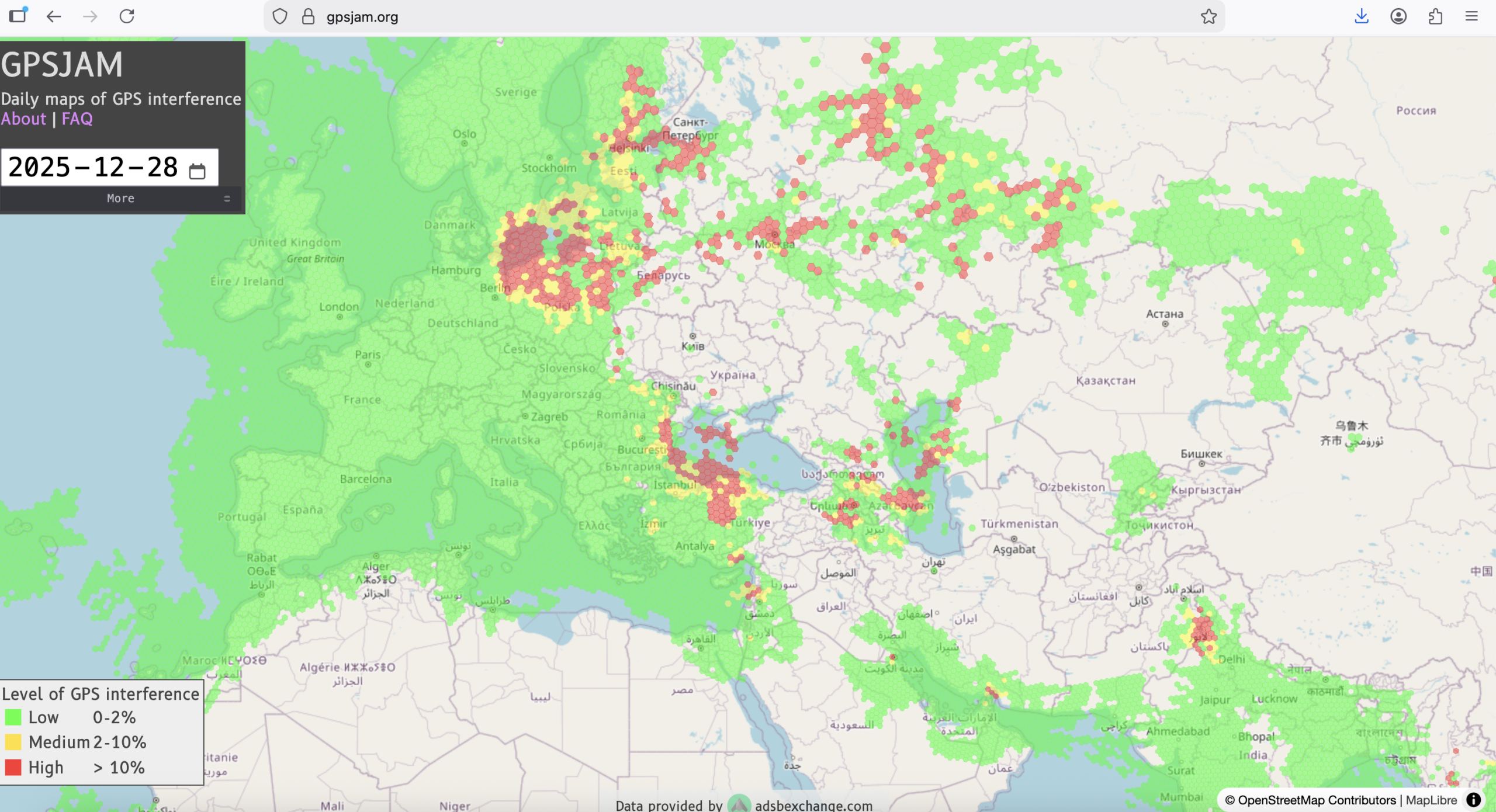
Organizations are paying closer attention to how systems behave under interference, whether they can fall back on multiple signals, and how gracefully they degrade when conditions worsen.
Precision still counts. But in 2025, the harder question is whether positioning holds up when conditions are less than ideal.
Edge Geospatial and Autonomous Systems Move Into Operations
Edge computing isn’t new. In 2025, it becomes unavoidable. In Earth Observation, the shift is now visible in mission design. The European Space Agency is increasingly treating onboard processing and edge analytics as mission-enabling capabilities, driven by rising data volumes, latency constraints, and the need for faster response in applications such as disaster monitoring and maritime surveillance.
Commercial EO systems reflect the same logic. First-pass analytics, such as cloud masking, change flags, or basic detection, are being performed on satellites or immediately at ground stations, prioritizing speed and throughput over raw data delivery.
On the ground, edge processing is now routine in drone and mobile workflows. Inspection, mapping, and monitoring operations rely on onboard inference to guide decisions during data capture, particularly in infrastructure, agriculture, and emergency response.
Robotics makes the shift explicit. Autonomous systems in construction, mining, agriculture, and utilities depend on tightly integrated stacks combining SLAM, GNSS, sensing, and local compute. In these environments, geospatial context is part of the control loop, not a post-processing step.
This direction is being recognized beyond the geospatial sector. Analysis from the World Economic Forum and the OECD points to edge computing as essential for real-time decision-making and operational resilience as autonomy scales and data volumes grow.
Reading the Signals from 2025
The changes unfolding in 2025 are not independent, but are all colliding. AI, Earth Observation, autonomy, sovereign infrastructure, and accountability pressures are all advancing at once. What determines whether they scale is not novelty, but integration.
Interoperability, long treated as background plumbing, is now shaping outcomes at a strategic level. LLMs depend on structured spatial inputs. Autonomous systems depend on tight alignment between sensors, positioning, and context. Evidence-based reporting depends on data that remains traceable and comparable over time.
Where those connections hold, systems move into operation. Where they don’t, deployment stalls. Not because the technology falls short, but because it cannot be reliably connected.
That is what makes 2025 different. Not a single breakthrough, but a growing intolerance for fragility in systems that are now expected to carry real-world consequences.


Be the first to comment