
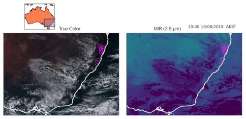
Australia’s first satellite that can help detect bushfires within one minute of ignition set for launch
An Australian company is planning to launch a satellite which is specialized to detect wildfires next year from the low Earth orbit. The project is targeted to find any fires within one minute. The full system is collaborated with ground-based cameras and drones. An algorithm is used to process every satellite photo in 60 seconds. Australia is currently relying on the Japanese weather satellite Himawari 8 to take one photo every 10 minutes, urging the need to have an own satellite for the country. The GSD of the new satellite is approximately 500 meters, meaning that fires smaller than a few football ovals might not be detected.
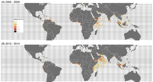
Why pirates attack: Geospatial evidence
There are many factors that caused piracy. The spatial analysis about the geographic locations of actual pirate incidents can help us to understand why and how the events happened. Somalia’s Exclusive Economic Zone is known to have active pirate activities for decades. A study has found a surprising result that piracy is not simply caused by poverty or unemployment. The existence of pirates is more related to the decline of local fishing industry caused by foreign illegal fishing fleets.
https://www.brookings.edu/blog/future-development/2021/03/15/why-pirates-attack-geospatial-evidence/
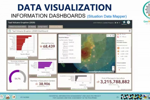
Philippines looks to improve disaster preparedness with geospatial technology
74% of Philippines’ population is vulnerable to natural disasters such as typhoons, earthquakes and volcano eruptions. The National Exposure Database built a GIS core to identify vulnerable areas for immediate disaster responses. Local governments can use the real-time analyses to develop solutions after catastrophes, for example to prepare disbursements for affected areas in terms of financial impact. The GIS tool can also be used for economic planning and even integrated with other regional platforms.
Navigation tech used at Heathrow Airport to be fast-tracked
A UK mapping company has received a 750,000 pound loan from the government to develop a new indoor navigation system. The company has already released the indoor map of Heathrow airport for flight connections. It received positive comments from the Singapore Airlines. With the additional funding, they can create more maps to cover large buildings and underground locations without GNSS signals. The new platform does not require expensive hardware to operate.

https://businesscloud.co.uk/navigation-tech-used-at-heathrow-airport-to-be-fast-tracked/
Cadbury’s Google Maps game lets you send real Easter eggs to your friends
Easter holiday is coming soon, however some areas are still affected by covid-19 and people are restricted to travel around. Cadbury will launch a virtual Easter egg hunt event on Google Map and everyone will be able to join it. Google Map Street view added a new pop up that users can stash an Easter egg anywhere in the world. The person can purchase an Easter Egg and hide it in the virtual world.
https://www.t3.com/us/news/google-maps-game-lets-you-send-real-easter-eggs-to-your-friends/


Be the first to comment