
- Supporting Informed Decisions with Spatial Tools in West Africa
- Using BIM to Preserve Ancient Timber Buildings
- Critical US Data for Hurricanes, Ice Monitoring will Remain Available
- Mapping the AI Data Centres in the World’s Driest Places
- Important Carbon Observation Platform At Risk Due to NASA Cuts
- Reimagining Healthcare with AI and BIM
Supporting Informed Decisions with Spatial Tools in West Africa
A new spatial tool is aiming to help farmers and policymakers in West Africa. The Spatial Decision Support System is a web-based tool designed to provide farmers, policymakers, NGOs, and researchers with easy access to climate, crop, and land-use data. The tool integrates observational data, high-resolution climate models, and remote sensing information, offering 28 practical indicators, such as rainfall patterns, irrigation needs, and vegetation health. At a time of changing climate and unpredictable weather patterns, geospatial tools like this will drive our world forwards.
To learn more click here, and for the interactive tool click here.
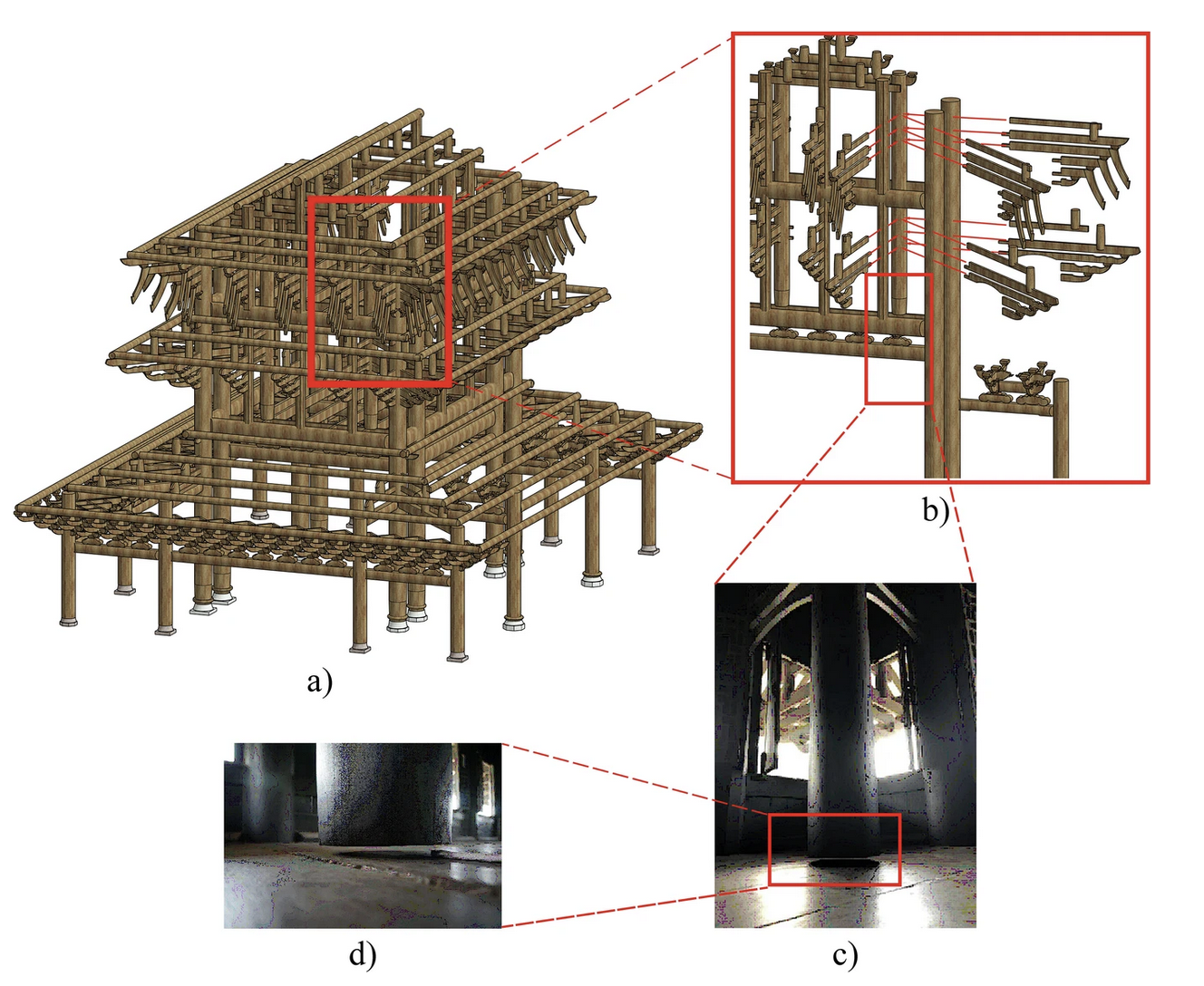
Using BIM to Preserve Ancient Timber Buildings
Researchers in China are archiving some of the oldest wooden buildings in the world thanks to 3D scanning and BIM technology. The team from Guilin University of Technology and Nanning College of Technology are employing 3D laser scanning and finite element simulation to create what they are calling heritage building information models (HBIM). They are hoping not only to create a digital replica of the buildings, but to use the scans for “effective conservation, restoration, research, and education”.
To learn more about the complexities offered by traditional Chinese architecture and how the team is overcoming these obstacles, click here.
Critical US Data for Hurricanes, Ice Monitoring will Remain Available
The U.S. Department of Defense will continue to share key data collected by three weather satellites that help forecasters track hurricanes. The data was originally intended to not be shared beyond the end of July, which led meteorologists and scientists to warn of risks to accurate and timely storm tracking. But after hearing from government partners, officials found a way to meet modernization goals while keeping the data flowing until the sensor fails or the program formally ends in September 2026.
To read more, click here.
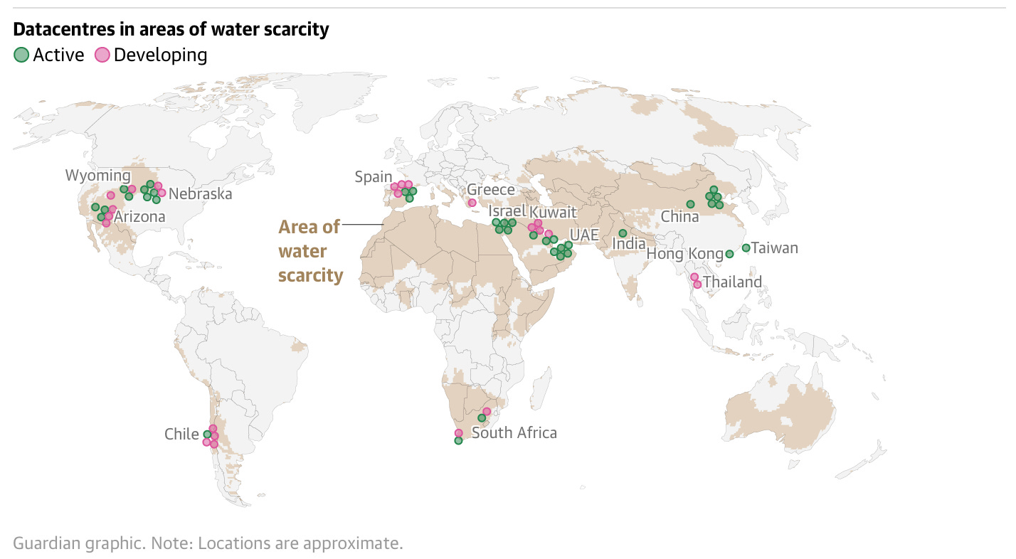
Mapping the AI Data Centres in the World’s Driest Places
A new article from the American Geographical Society takes a look at the location of major data centres in some of the world’s most at risk and water stressed localities. This includes two thirds of new data centres built or in development globally since 2022 being located in these water-stressed locations. We can see the approximate locations of Active (green) or Developing (pink) data centres that are located in the indicated ares of water scarcity. Not only is this a growing problem, but these data centres are found to consume up to 80% of water sourced for evaporative cooling, compared to roughly 10% consumption in typical residential evaporative cooling installations.
To learn more, click here.
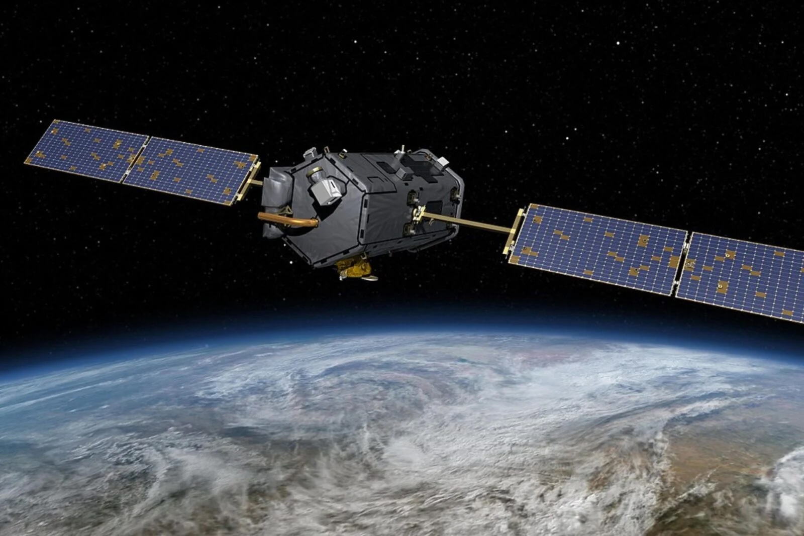
Important Carbon Observation Platform At Risk Due to NASA Cuts
And while we got the good news above that scientists will continue to have access to information for hurricane and ice forecasting, the American administration’s cuts are putting an important GHG monitoring platform at risk. The 2026 fiscal budget that includes heavy cuts to NASA has led to two satellite missions that provide important climate data being put at risk of cancellation. The Orbiting Carbon Observatories are a pair of instruments that map atmospheric carbon on a global scale. The OCO-2 and OCO-3, launched in 2014 and 2019 respectively, provide critical information that improved our ability to monitor human-driven carbon emissions alongside natural variations in the planet’s carbon cycle. The end of these satellite missions would “mark a significant scientific loss”.
To read more about the important work at risk of being lost, click here.
Reimagining Healthcare with AI and BIM
AI integration with BIM is revolutionizing healthcare facility construction and management. From centralized data management platforms that create digital twins for improved collaboration to AI-powered construction oversight tools that automate safety inspections and regulatory compliance. This combination could be the start of a paradigm shift toward intelligent, data-driven building lifecycle management. Integration of AI and BIM creates opportunities for enhanced predictive modeling, automated compliance checking, and real-time facility optimization. These capabilities could extend beyond healthcare to all complex facility types, so this is truly pioneering work.
To learn more, click here.


Be the first to comment