
- New NOAA Project Looks to Map Critical Mineral Deposits on Seafloor Off American Samoa
- UK Space Agency Funds Two New Agricultural Initiatives
- NOAA Launches New Wildfire Monitoring Data Portal
- Planetary Intelligence Harnesses the Power of Earth Observation Data and AI to Better Understand Planetary Systems
- Maps From NASA Show Increasing Frequency of Wildfires in the Far North
- New Maps of Antarctica Reveal the Landscape Beneath the Ice
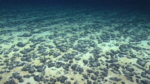
New NOAA Project Looks to Map Critical Mineral Deposits on Seafloor Off American Samoa
A new hydrographic survey project by the National Oceanic and Atmospheric Administration (NOAA) looks to map deposits of critical minerals in the waters off of American Samoa. This project is part of the U.S. Offshore Critical Minerals Mapping Plan and seeks to help the US obtain critical minerals for use in domestic supply chains. These minerals include manganese, nickel, cobalt, copper and rare earth elements, which have many uses including for defense, and smartphone batteries.
UK Space Agency Funds Two New Agricultural Initiatives
![]()
![]()
The UK Space Agency’s Unlocking Space for Business program is supporting two new pilot projects aimed at leveraging earth observation data to help farmers make better informed decisions about their land and crops. The first initiative, GeoCrop, is a tool that uses satellite imagery, weather data, and information on supply chains to help farmers determine the optimal time to plant their crops. The second initiative, Space Enabled Decarbonisation, Environmental and Regenerative Solutions (SEDERS), combines satellite data and data from small ground sensors to help farmers to monitor the health and biodiversity of their fields.
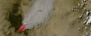
NOAA Launches New Wildfire Monitoring Data Portal
NOAA has recently launched the Wildland Fire Data Portal, a new data portal that provides public-access to their near real-time wildfire monitoring data. This data comes from the Next Generation Fire System (NGFS), which uses advanced algorithms and AI to detect heat signatures in satellite imagery and monitor the state of new and existing fires. The portal is not currently available in Canada.
Planetary Intelligence Harnesses the Power of Earth Observation Data and AI to Better Understand Planetary Systems
AI models trained on earth observation data could be extremely powerful tools able to help humanity predict and mitigate natural disasters and conflicts, and monitor the effects of climate change in real-time. Planetary Intelligence Models (PIM) trained on planetary data would be able to understand complex planetary systems as well as analyze patterns and predict outcomes. For example, these models would allow not only for the detection of natural disasters like wildfires and floods, but be able to provide predictions about where future ones might occur and what their effects might be, therefore enabling improved disaster response.
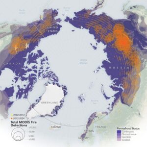
Maps From NASA Show Increasing Frequency of Wildfires in the Far North
New maps released by NASA based on data from their Moderate Resolution Imaging Spectroradiometer (MODIS) sensors show that the frequency and intensity of wildfires in the Arctic are increasing, particularly in Eurasia. According to researchers this increase can be attributed to rising temperatures due to climate change, as well as the increased occurrence of lightning in the far north which is responsible for the ignition of the majority of the fires.
New Maps of Antarctica Reveal the Landscape Beneath the Ice
Researchers have recently created a new method for mapping Antarctica’s landscape beneath the ice sheet that shows the continent in a never-before-seen level of detail. Previous techniques only allowed small sections to be surveyed at a time, resulting in maps with gaps tens of kilometers wide.
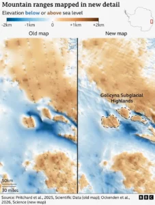
The new method uses satellite imagery of the ice sheet and knowledge of the physics of how ice moves to determine what lies underneath, resulting in highly detailed maps with no large gaps.


Be the first to comment