
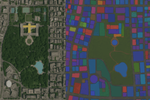
- AI Foundation Models for Earth Observation: A New Chapter in Geospatial Intelligence
- FAO’s upgraded ABC-Map warns of a sharp decline in Crop Suitability by 2100
- Real-Time GIS Dashboards Revolutionize Emergency Response
- GlobalBuildingAtlas: First Complete Open Global Dataset of 2D and 3D Building Models
- Geospatial Analysis shows Nature Risks in Global Investment Portfolios
- FAO stresses Remote Sensing Standards for Food Security
AI Foundation Models for Earth Observation: A New Chapter in Geospatial Intelligence
AI foundation models are reshaping Earth observation by processing multimodal data for applications such as flood detection, land use mapping, and climate monitoring. Unlike traditional methods, these models learn patterns directly from data and adapt across tasks. Key initiatives include IBM’s TerraMind, Google’s disaster response models, and Meta’s SAM adapted for remote sensing. Open-source tools such as Development Seed’s Clay and Element84’s geospatial AI projects are broadening accessibility and use. These models are driving real-time insights and decision-making in EO. Read more in detail at the full article link.
FAO’s upgraded ABC-Map warns of a sharp decline in Crop Suitability by 2100
The Food and Agriculture Organization of the United Nations (FAO)’s upgraded ABC-Map tool now includes a new indicator revealing that key crops like wheat, coffee, beans, cassava, and plantain could lose up to half of their most suitable land by 2100 due to climate change. Developed using global satellite data and studies by Finres and the International Fund for Agricultural Development (IFAD), the tool helps assess climate risks for agriculture. Users can analyze future crop suitability by location and emission scenario, supporting long-term adaptation planning. ABC-Map, part of FAO’s Nationally Determined Contributions NDC Toolbox, aids in aligning agriculture with climate and biodiversity goals under the Rio Conventions. Read more here.
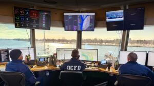
Real-Time GIS Dashboards Revolutionize Emergency Response in Washington, DC
The District of Columbia Fire and Emergency Medical Services Department (DC Fire & EMS) has transformed emergency response through a unique collaboration between firefighter Jeffrey Lenard and GIS analyst Tim Hutchison. Using Esri’s GIS tools, they developed real-time dashboards that integrate incident data, resource tracking, and personnel monitoring across six bureaus. From maritime rescue operations to blood supply management and subway incident coordination, these dashboards have improved situational awareness and response times. Innovations include visual/audio alerts, a Unit Welfare Timer, and predictive analytics for resource planning. Supported by DC’s centralized Office of the Chief Technology Officer (OCTO) enterprise GIS infrastructure, the tools continue to enhance public safety and emergency medicine across the city. Find full details here.
GlobalBuildingAtlas: First Complete Open Global Dataset of 2D and 3D Building Models
GlobalBuildingAtlas is the first open dataset offering complete global coverage of building footprints, estimated heights, and Level of Detail 1 (LoD1) 3D building models. Covering over 2.75 billion buildings worldwide, it provides 3×3 meter spatial resolution using PlanetScope satellite data and machine learning pipelines. The GBA.LoD1 dataset includes 2.68 billion buildings with predicted heights and over 97% height completeness, with RMSEs ranging from 1.5 to 8.9 meters across continents. It surpasses existing databases by more than 1 billion buildings and supports detailed analysis of urban density, infrastructure, and SDG monitoring. Read the full research article here.

Geospatial Analysis shows Nature Risks in Global Investment Portfolios
A new study by Morgan Stanley Capital International Inc. (MSCI Inc.), using geospatial data and the World Wide Fund for Nature’s Biodiversity Risk Filter (WWF BRF), shows that 41% of physical assets in the MSCI All Country World Index Investable Market Index (MSCI ACWI IMI) face at least one high nature-related risk. The most common risks are related to air quality, water availability, and timber supply. The study reviewed over 450,000 assets and found that sectors like energy, mining, and agriculture depend heavily on water. Risks like soil condition and pollination affect food and forest sectors. Areas such as U.S. semiconductor hubs face water stress, which may affect global portfolios. Read more infomration from the link here.
FAO stresses Remote Sensing Standards for Food Security
At the 44th Symposium of the European Association of Remote Sensing Laboratories (EARSeL), held in Prague from 26 to 29 May 2025, the Food and Agriculture Organization of the United Nations (FAO) emphasized the need for standardized remote sensing methods. FAO presented its proposed standards for field data collection, land cover mapping, and data sharing, which support sustainable agriculture and align with Sustainable Development Goal 2: Zero Hunger. Key topics included crop mapping, drought monitoring, and early warning systems. Challenges such as cloud cover, data access, and high processing costs were discussed, along with the role of FAO’s Agro-Informatics platform in supporting global food security efforts. Collect the full information here.


Be the first to comment