
- Satellite monitoring is used to detect blockages along a major livestock migration route in Sudan.
- Swedish Armed Forces signed satellite services agreement with Planet Labs
- Interactive data center map for Prince William Country, Virginia
- MIT launched a new model to map foot traffic in New York City
- EarthDaily Constellation will launch commercial operations in summer 2026, delivering daily global coverage.
- WMO sets implementation guidelines for National Renewable Energy Atlases (NRAs) for its members
Satellite monitoring is used to detect blockages along a major livestock migration route in Sudan
In Sudan, this traditional migration, known as transhumance, has become a source of conflict. As farmland expands, historic livestock corridors are shrinking, forcing herders onto cultivated land or blocking access to grazing areas and water, sparking disputes between farmers and pastoralists.
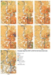
A space-based solution was used to map potential conflict triggers. The European Space Agency, in partnership with International Fund for Agricultural Development and its funded Sustainable Natural Resources and Livelihoods Programme, deployed Earth observation technology to detect blockages that could spark disputes along a key livestock route in Sennar State. Read full story here
Swedish Armed Forces have signed satellite services agreement with Planet Labs
![]()
![]()
“Europe needs its own eyes, and Sweden is leading the way by rapidly securing its own, comprehensive space capability – helping achieve its own security objectives and assisting regional allies, like Ukraine, with timely, critical information,” said Will Marshall, Planet CEO and Co Founder.
Planet Labs PBC has entered into a multi–year contract worth a low nine–figure amount with the Swedish Armed Forces to provide a range of satellites, space–based data, and situational awareness solutions to support Sweden’s peace and security missions. Read full story here
Interactive data center map for Prince William Country, Virginia
Prince William County has recently launched an interactive mapping tool to monitor the progress of datacenter construction. The tool provides project-specific information including acreage, location, development status, planned square footage, zoning classifications, and related zoning case numbers, accessible through both the county mapper and the built-on analysis dashboard.
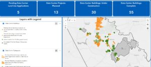
By consolidating data from various departments into a single interactive platform, we aim to help the community better understand ongoing developments, ask informed questions, and remain involved as the county plans for future growth. Read full story here
MIT launched a new model to map foot traffic in New York City
A research team at MIT has created a navigable dataset of sidewalks, crosswalks, and footpaths covering the entire city of New York — a large-scale mapping initiative and the first comprehensive model of pedestrian movement in any city in the United States.

The model can assist planners in determining where to invest in pedestrian infrastructure and public spaces, as well as reveal how development choices might impact non-motorized travel within the city. Additionally, the study identifies areas across the city with a high volume of pedestrians combined with significant pedestrian risks, like traffic accidents, highlighting streets or intersections that require improvements the most. Read full story here
EarthDaily Constellation will launch commercial operations in summer 2026, delivering daily global coverage
The EarthDaily Constellation, built by EarthDaily Analytics, is progressing from its first satellite launch toward full commercial service. The constellation will be expanded with six more satellites in an upcoming launch and further additions later in the year. Once complete, it is expected to begin commercial operations in summer 2026, providing daily, consistent global Earth observation coverage.

This system aims to deliver high-frequency, high-quality imagery for a range of commercial and government uses, enhancing change detection and data services worldwide as the constellation scales up. Read full story here
WMO sets implementation guidelines for National Renewable Energy Atlases (NRAs) for its members
The World Meteorological Organization (WMO) has published technical guidelines aimed at supporting countries in the assessment and mapping of renewable energy resources.
By transforming meteorological data into actionable knowledge, the guidelines enable countries to enhance the security of their energy supplies and expedite the shift towards renewable energy sources amid a changing climate. A key aspect of the initiative is its emphasis on high spatial resolution—4 kilometers or less—which facilitates more precise evaluation of renewable energy resources at local and regional levels.
This degree of granularity is essential for effective local and regional planning, permitting governments and private investors to identify optimal sites for the development of new energy infrastructure. Read full story here


Be the first to comment