
- Aechelon and Partners Launch Project Orbion to Build a Live Digital Twin of Earth
- NASA Satellites Reveal New Island in Alaska’s Alsek Lake
- DE Africa and PACE Empower Senegal with Geospatial Technologies
- UK Space Agency Funds Six Projects Using Satellites and AI for Climate and Transport Innovation
- NGA Awards BlackSky New Contract for AI-Powered Change Detection
- Ecopia AI and Maxar Partner to Deliver Global 3D Mapping Dat
Aechelon and Partners Launch Project Orbion to Build a Live Digital Twin of Earth
Aechelon Technology, alongside partners Niantic Spatial, ICEYE, BlackSky, and Distance Technologies, has unveiled Project Orbion, an initiative that combines satellite imagery, radar intelligence, photogrammetry, and AI to create a real-time 3D digital twin of the planet. The system integrates accurate physics, live weather, and Synthetic Reality (SR) to support applications ranging from disaster response and urban rescues to defense and shipping route monitoring.
The project also aims to enhance AI training with real-world conditions data, going beyond simulated inputs. Niantic’s Visual Positioning System (VPS), ICEYE’s radar satellites, BlackSky’s high-resolution imagery, and Distance’s 3D displays will be key technologies in the effort. By fusing these capabilities with Aechelon’s mission-grade visualization and simulation systems, Project Orbion promises new levels of situational awareness for emergency responders, defense teams, and corporate users alike.
Read more about Project Orbion here.

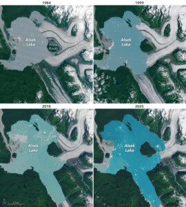
NASA Satellites Reveal New Island in Alaska’s Alsek Lake
NASA’s Landsat imagery has captured the formation of a brand-new island in Alaska, created by the rapid retreat of the Alsek Glacier. The glacier has pulled back more than 3 miles (5 km) since 1984, leaving a once-connected mountain, Prow Knob, completely surrounded by water. The transformation is clearly visible in images taken in 1984 and 2025, which show the glacier thinning and Alsek Lake expanding from 17 to 29 square miles over four decades. Scientists estimate the new island, about 2 square miles in size, emerged between July and August 2025. This development highlights the speed at which glacial retreat is reshaping landscapes in Southeast Alaska. As the glacier continues to recede, researchers warn of increased instability, ice calving, and long-term impacts on the region’s hydrology and ecosystems.
Read more about the discovery here.
DE Africa and PACE Empower Senegal with Geospatial Technologies
Digital Earth Africa (DE Africa) and the Pan African Consortium of Experts (PACE) are working together to expand the use of Earth observation data in Senegal. DE Africa provides decision-ready satellite data to monitor issues such as agriculture, water resources, and urban growth, while PACE connects this technology with local expertise and networks. From July to August 2025, the two organizations co-hosted a five-part workshop series tailored to Senegal’s development priorities. More than 130 participants gained hands-on training in crop monitoring, water mapping, and urban growth analysis, with an introduction to machine learning for tracking Sustainable Development Goals.
This partnership strengthens technical capacity in Senegal and supports wider goals under Africa’s Agenda 2063 and the UN SDGs. By making Earth observation more accessible, DE Africa and PACE are helping institutions design effective policies and respond to local challenges.
UK Space Agency Funds Six Projects Using Satellites and AI for Climate and Transport Innovation
The UK Space Agency has committed £1.5 million to six projects that combine satellite data with artificial intelligence to tackle climate change, improve transport, and support accessibility. The funding is part of the Unlocking Space for Business programme, aimed at driving innovation in sectors that have not traditionally used space technology.
The projects include a carbon risk dashboard for shipping (Ether Capital), a rail electrification planning tool (Furrer+Frey), and navigation systems for visually impaired pedestrians (MakeSense Technology). Other initiatives from Howden, Rebalance Earth, and Foresight Group will use satellite intelligence to improve biodiversity and climate risk assessments. Together, these efforts highlight the role of space-enabled solutions in supporting net zero goals, sustainable finance, and inclusive transport.

NGA Awards BlackSky New Contract for AI-Powered Change Detection
BlackSky has secured a new Luno A delivery order from the U.S. National Geospatial-Intelligence Agency (NGA), expanding its role in automated change detection. The six-figure deal provides access to BlackSky’s Spectra platform, which uses AI and computer vision to track anomalies and human-driven changes at machine speed and global scale.
The order will leverage BlackSky’s Gen-3 and Gen-2 satellite imagery, combined with commercial data sources, to monitor activity across climate, infrastructure, resources, and security. It builds on a broader five-year, $290 million contract awarded in October, positioning BlackSky as a key player in delivering real-time geospatial intelligence for national security and policy decisions.
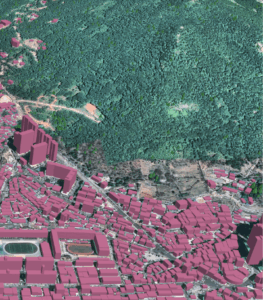
Ecopia AI and Maxar Partner to Deliver Global 3D Mapping Data
Toronto-based Ecopia AI has announced a partnership with Maxar Intelligence to produce high-precision 3D mapping data at a global scale. The collaboration combines Ecopia’s AI-driven feature extraction with Maxar’s archive of 30 cm satellite imagery, aiming to generate more than one billion features worldwide. The resulting data supports applications in land use planning, disaster response, public safety, and geospatial intelligence.
Ecopia’s platform can efficiently extract vector features with over 95% geometric accuracy, eliminating the need for manual digitization and ensuring maps remain current as new imagery is captured. Already in use by U.S. and international government agencies, the Ecopia 3D Land Cover product powered by Maxar provides a dynamic digital twin foundation that can scale across continents while maintaining interoperability and accuracy.
Read more about the partnership here.


Be the first to comment