
Xona Space Systems is on track for a dedicated constellation of LEO satellites to provide resilient positioning, navigation, and timing
What is Alt PNT? What are the key types of solutions in place or in development?
Our work and daily lives are becoming more dependent on geospatial, digital connectivity and remote collaboration. And all of this is heavily dependent on the positioning, navigation, and timing (PNT) that GPS/GNSS provides. This dependence, perhaps over-dependence, represents a key vulnerability. Alternatives and backup solutions are being rapidly developed and deployed—even in some cases mandated—for critical applications, industries, and infrastructure.
As a follow-up to our April 18, 2021 feature “Progress in Addressing GPS/GNSS Vulnerabilities” we examined the vulnerabilities, but also the positive steps being made to proactively solve the issues, we offer this, the fourth installment of a series where we explore Alt PNT technologies and the present work of developers and solution providers.
A Dedicated Constellation
“We are building our own satellite constellation, commercial satellites, dedicated to navigation functionality,” says Tyler Reid, Co-Founder and CTO for Xona Space Systems. “We’re not trying to piggyback on some of the communications focused systems, but we are leverage the ecosystem that is supporting the rapid rise of LEO satellite systems going up right now.”

Reid is referring to communications systems like SpaceX’s Starlink with about 800 of a planned 4500 of more sats in place, OneWeb at 70+ of a planned 720, Telesat working towards about 300, and Amazon’s vision of a constellation of over 3,000. There have been many proposals and explorations of leveraging communications satellites like these for positioning, navigation, and timing. But it is quite difficult, if not functionally impractical, to add PNT elements to satellites that are already optimizing limited on-board resources. “It really quite tough because you are trying to build a ‘Jack-of-all-trades’,” says Reid. “Something that ends up not being good at neither communication nor navigation.” For example, the UK has been looking at such co-use alternatives to mitigate the potential loss of Galileo for some of its PNT applications; though it is unclear if this might even be feasible.
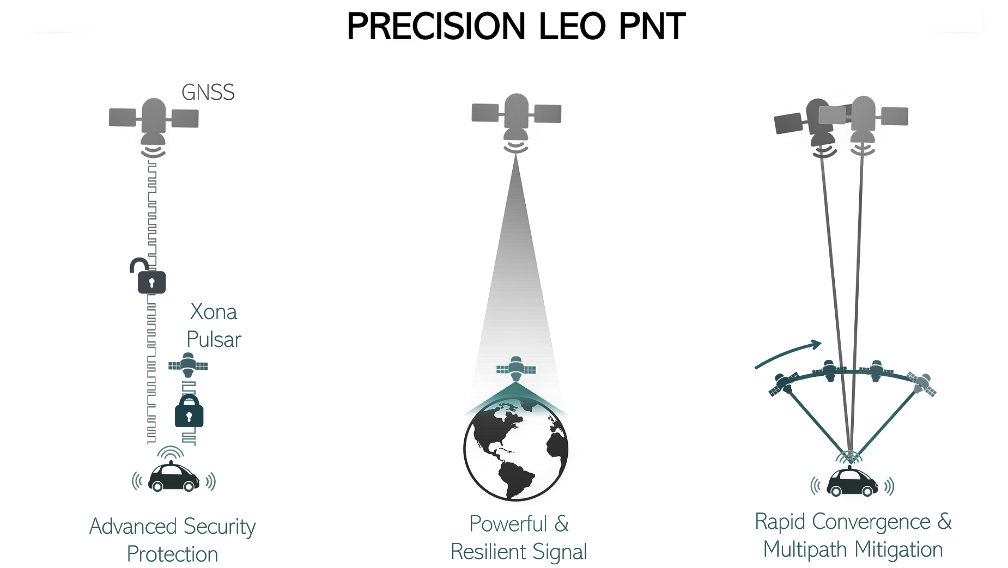
Instead of trying to piggyback on such systems, Xona Space is working towards a dedicated constellation of 300 or more LEO sats. “We are approaching this in phases,” says Bryan Chan, Co-Founder, Business Development at Xona Space Systems. “The current phase for R&D uses local networks of terrestrial transmitters. In 2023 we plan to have 40 LEO satellites over heavily populated areas, 70 in 2024, and the full constellation of 300 in 2026. Xona Space can benefit from an ecosystem in the aerospace industry of satellite businesses, creating satellite components and subsystems, available in high numbers and leveraging those economies of scale.”
Drivers
The current flurry of activity in development of PNT alternatives is fueled primarily by interest and growth in intelligent and autonomous systems, and the emphasis on safety-of-life reliability when considering the vulnerabilities of GNSS-based PNT. The stakes are high, and so are the expectations. “Look at air travel, where the there is one fatality for every 10 billion miles travelled,” says Reid. “The navigation precision needed for air travel is hundreds of meters, even rail and other modes of transportation can be in the 3 meter-plus ranges, but for vehicular autonomy, you need 30cm or less, and to match air travel would only allow for one 30cm failure every 1 billion miles.” Not only do precision thresholds have to be met, but more important, reliability and resilience.
Positioning and navigation evolved from 25m precision with the first satellite navigation system in the mid-20th century, the Doppler-based Transit system, and soon after with GPS for 3m. But now, with augmentations, GPS/GNSS can yield 10cm or less in real-time, just about anywhere in the world. Autonomy systems do not rely on GNSS alone, they employ multiple sensors for two types of spatial resolution. For relative positioning, there are combinations of cameras, LiDAR, radar and ultrasonic sensors, wheel-speed sensors, and more. For absolute positioning, GNSS integrated with IMUs. Expectations (and often stated requirements) for intelligent and autonomous systems are 10cm 95% of the time, and 30cm at the aforementioned extremely low failure rate. Arguably, GNSS could meet these needs, but many feel it could not when the risk such vulnerabities represent are factored in.
LEO Advantages and Challenges0
GNSS satellites are in medium earth orbit (MEO), around 20,000 km, LEO is typically under 1,000 km. The stronger signals are much more resistant to interference, and the rapidly moving geometry can yield very tight solutions. You need many more satellites though, but this is balanced out by the much lower costs to build, launch, and operate. A small sat may cost $100K-$1M, while GNSS sats (and supporting systems) can run hundreds of millions each.
Xona Space is building sats bigger than the little “CubeSats” we see so much about. “Our main constraint is that we’re power hungry. And that comes down to how much power we’re trying to put into the signal that will reach the ground,” says Reid. “This is a function of one of the pieces we’re trying to bring to the table—the element of improved resilience.”
GNSS satellites have on-board atomic clocks, that are updated from the respective ground segment, but Xona Space is taking a more practical approach. “A huge component of GNSS satellites is that long term stability clock, which is a great asset in orbit,” says Reid. “But when you dive into the requirements for those clocks, for instance government use cases for where the whole ground segment goes out for weeks at a time. Of course, for those contingencies it would be great to have those assets and atomic frequency standards up there. But they do drive up the cost and complexity of the satellite dramatically. What we’ve opted to do is to keep that complexity on the ground, and then offload the synchronization of the network to the satellites. And so, we’re still maintaining good short-term stability on the satellites, and able to do low noise signals.”
Solutions
While not wishing to reveal too much about their solution yet, Reid says that they are employing signal ranging approaches that share similarities to the code and carrier of current MEO GNSS systems. “Starting next June [2022], we’ll be launching our first demonstration satellite, and the second in October,” says Reid. This is to test satellite ranging from those two satellites. In many ways we are following the trilateration approach of GPS ranging, passive ranging from those satellites. And that forms a steppingstone to the larger constellation ultimately.”

“276 is our nominal number right now. And building a constellation like that is definitely not trivial,” says Reid. “We’ve set out a staged rollout, as Bryan mentioned. The first step in that is to offer effectively GNSS augmentation as service over population centers—30 to 40 satellites. Then with our constellation of 60-70 globally, we could support things for the time transfer industry, offering resilient time transfer for stationary users. But then also offering an additional source of information to overlay correction services on top of GNSS. In addition to offering an additional ranging signal, which has some of these new properties (leveraging that fast motion of the satellite across the sky for faster convergence), helping improve PPP (precise point positioning) and other techniques.”
With a full complement of LEO satellites (around 300), the same dilution of precision (DOP) as GNSS can be achieved, and then the work of improving precision begins. Reid indicated that precision would come in phases, initially in meters, along with the time transfer and corrections services. Then the 30cm and 10cm levels for the envisioned intelligent and autonomous applications.
Refining these solutions is their point of focus, and the expertise they bring to the table. “We’re definitely lucky in that we’re standing on the shoulders of giants in the LEO domain,” Says Chan. “There’s lots of folks trying to provide things like satellite internet from small satellites. And there’s a lot of folks who’ve done a lot of work to get those form factors small and getting these kinds of radio payloads and power systems up and running. So, we’re glad to not have to start from scratch there.”
Origins and Future
“Some of us who founded Xona Space met in grad school at Stanford,” says Chan. “Most of our team come from related technology backgrounds. For instance, my background is aeronautics and astronautics; I worked for Maxar, one of the leaders in building those big geo communications satellites.” Dr. Reid studied and taught aeronautics and astronautics at Stanford University. He then did a stint with Ford, working on self-driving cars and navigation and mapping for those systems.
The company formed in 2019 in the Bay Area, and now has branches in Canada and the UK. Chan says the word Xona is an extension of very small metric increments (i.e. 1027), apropos considering their focus on precision (plus it sounds cool and space-ish).
They rapidly garnered a lot of interest, receiving a National Science Foundation grant in 2020 and international media attention. They were chosen, from 350 applicants to be included as one of eight startups into an accelerator program of the National Geospatial Intelligence Agency (NGA). They have entered into a collaboration with Spirent Federal, and more recently it was announced that their inaugural LEO mission has been fully financed.
Many in the industry predict that LEO based positioning could provide 10x the accuracy (for some applications) and 100x better mitigation of interference than legacy GNSS systems. By this time next year Xona Space’s first two LEOs should be in orbit and ready for a shakedown cruise of their PNT solutions, helping get us closer to that future. More details in a video presentation by Tyler Reid: Commercial LEO PNT for Autonomy, from the Multi GNSS Asia Location Tech Intro Series 2021.


Be the first to comment