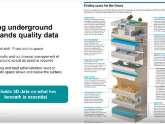
• facebook
  • Twitter
  • Linkedin
  • Youtube
  • Linkedin Group
  • Post a Job
  • Post an Ad
  • Post an Event
  • Post a Directory Listing
  • Post a Press Release
  • Media Kit
  • My Account
  • Login
GoGeomatics
  • MAGAZINE
    • BIM & GIS
    • Community
    • Conference news
    • Earth Observation
    • Education & Careers
    • GEOAI
    • Announcements
    • Reality Capture & Lidar
    • Science
    • Technology
    • Between the Poles
  • Directories
    • ASSOCIATION
    • INDUSTRY
    • EDUCATION
    • Open Data
  • EVENTS
    • GeoIgnite Events
    • Events Calendar
    • GoGeomatics Meetups
  • Services
    • Advertising
    • Marketing
    • Post a Job
    • Post an Ad
    • Post an Event
    • Post a Press Release
    • Post a Directory Listing
    • Media Kit
    • Web Design
  • Find a Job
  • Volunteer
    • Start a GoGeomatics Group
    • Editors & Writers Group
  • About Us
    • About Us
    • Contact Us
    • Frequently Asked Questions
  • Videos
HomeBetween the Poles – The Geoff Zeiss Archives3D data

3D data

3D data

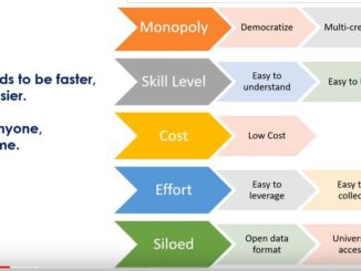
Product-as-a-Service:a paradigm shift in low cost access to advanced underground mapping technology

12 August 2022 Geoff Zeiss

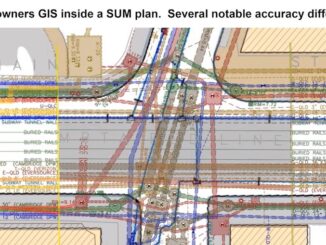
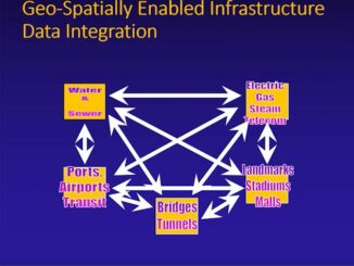
Gyro or inertial mapping provides an effective technical solution to the challenge of accurately mapping underground utility infrastructure. Gyro mapping solutions are available for any type of underground utility including water, gas, electric power, communications, […]

3D data

Automated feature recognition helps democratize utility mapping for producing infrastructure digital twins

19 July 2022 Geoff Zeiss

In jurisdictions worldwide the low quality of underground location data has been identified as a top cause of underground utility damage. Existing underground utility data, most of which is stored in network owners’ records, is […]

3D data

An infrastructure digital twin provides a dynamic environment for managing underground assets of a multi-utility campus

6 July 2022 Geoff Zeiss

For organizations managing a campus such as educational facilities, healthcare facilities, commercial real estate, utilities, and municipalities managing public works, storm sewer systems, and parks which are characterized by having many different utilities and and […]

3D data

ASCE standards reduce risk and expedite public highway construction projects

20 June 2022 Geoff Zeiss

What the engineer does during planning and design has a multitude of impacts: traffic disruptions to the public, safety for workers on construction sites, avoiding delays and budget overruns on projects, decreasing risk to contractors, […]

3D data

Combining traditional data with advanced GPR provides a complete picture of the subsurface

16 June 2022 Geoff Zeiss

When we look at some of the major projects that have gone sideways, it often can be attributed to the lack of planning for underground infrastructure. This is a global issue and we know that […]

3D data

Accurately locating and mapping utility infrastructure underwater

13 June 2022 Geoff Zeiss

In New Jersey there was a $320 million project to replace a bridge connecting Stafford Township to Long Beach Island. There are many utilities involved including telecom, Comcast, water and sewer, and electric and conduits. […]

3D data

Developing a subsurface digital twin for Singapore requires data quality management

7 June 2022 Geoff Zeiss

Singapore has severely limited land, but unlimited space and has started to build many types of activities underground to save the land above ground for the better living of citizens. Many of the traditional utilities […]

3D data

Standards-based subsurface data model key objective of New York’s underground infrastructure resilience project

3 June 2022 Geoff Zeiss

Improving disaster resilience requires accurate data about subsurface utility and other infrastructure. New York has has experienced several disasters over recent decades, foremost among them 9/11 and Hurricane Sandy. The experience of 9/11 and Hurricane […]

Posts pagination

1 2 … 30 »

Events

Feb 16
February 16 @ 8:00 am - February 18 @ 5:00 pm

GeoWeek 2026

Feb 17
5:00 pm - 8:00 pm

Victoria GoGeomatics February Mappy Hour

Feb 17
6:00 pm - 8:00 pm

Calgary GoGeomatics February Social

Feb 18
6:30 pm - 8:30 pm

Vancouver GoGeomatics Meetup – February 2026

Feb 19
February 19 - February 22

Spatial Knowledge and Information Canada 2026

View Calendar

View All Events

Services

  • Post a Job
  • Post an Ad
  • Post an Event
  • Post a Directory Listing
  • Post a Press Release
  • Media Kit
  • My Account
  • Login

Jobs

Post a Job
  • Volunteer Editorial Contributor – Be Part of Canada’s Geomatics Story
    Remote
  • Junior Geomatics Field Technician – Technical Surveys
    Montréal, QC
  • GIS Specialist
    Amherst, Nova Scotia
  • Precast Structural BIM Specialist
    Calgary, Alberta
View All Jobs
  • Directories
    • Associations Directory
    • Industry Directory
    • Education Programs
    • Open Data
  • Volunteer
    • Start a GoGeomatics Group
    • Editors & Writers Group
  • About Us
    • GoGeomatics Media Kit
    • Who We Are
    • Contact Us
    • FAQ’s
    • Advertising
    • Marketing
  • Subscribe
GoGeomatics
GoGeomatics is the largest and most popular communications hub promoting the Canadian geospatial community. The business was incorporated in 2011. GoGeomatics hosts over 100 fun, free, location technology networking events each year in cities across Canada.

© 2026 GoGeomatics

  • facebook
  • Twitter
  • Linkedin
  • Youtube
  • Linkedin Group