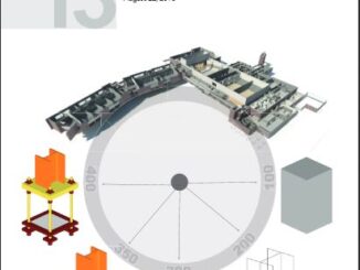
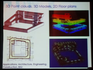
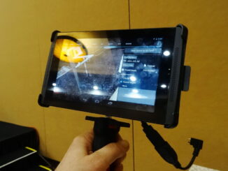
• facebook
  • Twitter
  • Linkedin
  • Youtube
  • Linkedin Group
  • Post a Job
  • Post an Ad
  • Post an Event
  • Post a Directory Listing
  • Post a Press Release
  • Media Kit
  • My Account
  • Login
GoGeomatics
  • MAGAZINE
    • BIM & GIS
    • Community
    • Conference news
    • Earth Observation
    • Education & Careers
    • GEOAI
    • Announcements
    • Reality Capture & Lidar
    • Science
    • Technology
    • Between the Poles
  • Directories
    • ASSOCIATION
    • INDUSTRY
    • EDUCATION
    • Open Data
  • EVENTS
    • GeoIgnite Events
    • Events Calendar
    • GoGeomatics Meetups
  • Services
    • Advertising
    • Marketing
    • Post a Job
    • Post an Ad
    • Post an Event
    • Post a Press Release
    • Post a Directory Listing
    • Media Kit
    • Web Design
  • Find a Job
  • Volunteer
    • Start a GoGeomatics Group
    • Editors & Writers Group
  • About Us
    • About Us
    • Contact Us
    • Frequently Asked Questions
  • Videos
HomeBetween the Poles – The Geoff Zeiss Archives3D data

3D data

3D data

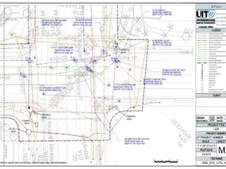
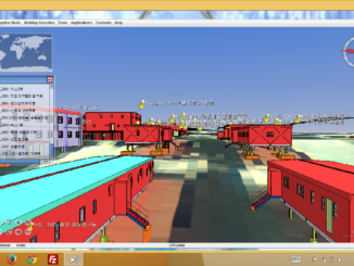
Korea’s BIM on GIS project is developing a platform for spatial interoperability

7 May 2014 Geoff Zeiss

At the Geospatial World Forum in Geneva, several geospatial-related projects from South Korea are being highlighted.  One of the most important is a five-year project conceived, sponsored and funded by the Korean Institute of Construction […]

3D data

Classifying geolocation information about subsurface utilities

5 May 2014 Geoff Zeiss

I’ve blogged several times about the expanding effort in Europe and the United States to map accurately underground infrastructure.  I blogged about the high ROI for investment in improving the geolocation and other information about […]

3D data

Automated code-checking: Review of 28 national, state, city and third-party BIM standards and guidelines

2 May 2014 Geoff Zeiss

Checking regulatory compliance for building permitting remains a tedious, time-consuming and costly process. While the critical importance of timely, accurate, and uniform code review has been an important goal of regulatory agencies for some time […]

3D cadastre

Progress on the Dutch 3D geospatial standard-integration with open source geospatial tools

1 May 2014 Geoff Zeiss

At the Geospatial World Forum in Amsterdam two years ago, Jantien Stoter of the Delft Univeristy of Technology and an advisor to Geonovum, gave an overview of the work on a Dutch 3D standard, which […]

3D data

Construction industry moving to maximize geospatial content

28 April 2014 Geoff Zeiss

At the SPAR International conference Kevin Gilson, Director of the Design Visualization group at  Parsons Brinckerhoff (PB) gave an insightful presentation on integrated 3D modeling and visualization for large transportation projects with some examples from […]

3D data

Standard level of development (LoD) specification for BIM models

24 April 2014 Geoff Zeiss

At the Spring BIMForum in Boston James Vandezande and Will Ikerd gave an update on the status of the BIMForum’s Level of Development (LoD) specification.  The Level of Development (LOD) Specification is a reference that […]

3D data

Mobile scanning interiors of buildings with automatic feature extraction for energy performance modeling

17 April 2014 Geoff Zeiss

At the SPAR International conference Avideh Zakhor from the University of California Berkeley gave an enthralling presentation about her research on capturing optical and thermal point clouds of the insides of buildings using a portable […]

3D data

Handheld scanners set to revolutionize construction

16 April 2014 Geoff Zeiss

At the SPAR International Conference today Kirk Knorr from Burns & McDonnell and Gregory Lawes of point3D gave a presentation about their experience using a handheld scanner from DotProduct LLC.  This is a professional device […]

Posts pagination

« 1 … 25 26 27 … 30 »

Events

Notice
There are no upcoming events.

View All Events

Services

  • Post a Job
  • Post an Ad
  • Post an Event
  • Post a Directory Listing
  • Post a Press Release
  • Media Kit
  • My Account
  • Login

Jobs

Post a Job
  • Volunteer Editorial Contributor – Be Part of Canada’s Geomatics Story
    Remote
  • Junior Geomatics Field Technician – Technical Surveys
    Montréal, QC
  • GIS Specialist
    Amherst, Nova Scotia
  • Precast Structural BIM Specialist
    Calgary, Alberta
View All Jobs
  • Directories
    • Associations Directory
    • Industry Directory
    • Education Programs
    • Open Data
  • Volunteer
    • Start a GoGeomatics Group
    • Editors & Writers Group
  • About Us
    • GoGeomatics Media Kit
    • Who We Are
    • Contact Us
    • FAQ’s
    • Advertising
    • Marketing
  • Subscribe
GoGeomatics
GoGeomatics is the largest and most popular communications hub promoting the Canadian geospatial community. The business was incorporated in 2011. GoGeomatics hosts over 100 fun, free, location technology networking events each year in cities across Canada.

© 2026 GoGeomatics

  • facebook
  • Twitter
  • Linkedin
  • Youtube
  • Linkedin Group