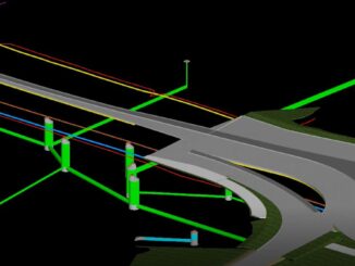
• facebook
  • Twitter
  • Linkedin
  • Youtube
  • Linkedin Group
  • Post a Job
  • Post an Ad
  • Post an Event
  • Post a Directory Listing
  • Post a Press Release
  • Media Kit
  • My Account
  • Login
GoGeomatics
  • MAGAZINE
    • BIM & GIS
    • Community
    • Conference news
    • Earth Observation
    • Education & Careers
    • GEOAI
    • Announcements
    • Reality Capture & Lidar
    • Science
    • Technology
    • Between the Poles
  • Directories
    • ASSOCIATION
    • INDUSTRY
    • EDUCATION
    • Open Data
  • EVENTS
    • GeoIgnite Events
    • Events Calendar
    • GoGeomatics Meetups
  • Services
    • Advertising
    • Marketing
    • Post a Job
    • Post an Ad
    • Post an Event
    • Post a Press Release
    • Post a Directory Listing
    • Media Kit
    • Web Design
  • Find a Job
  • Volunteer
    • Start a GoGeomatics Group
    • Editors & Writers Group
  • About Us
    • About Us
    • Contact Us
    • Frequently Asked Questions
  • Videos
HomeBetween the Poles – The Geoff Zeiss Archives3D data

3D data

3D data

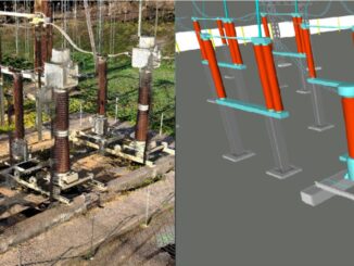
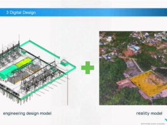
First substation built using full life-cycle BIM construction goes live one month early

5 November 2019 Geoff Zeiss

Hubei Electric Engineering Corporation (HEEC) was this year’s winner of the Bentley Year in Infrastructure Communications and Utilities award.  One of the key objectives of the ground-breaking CNY 120 million (US$16.8 million) Miluo Western 220kV […]

3D data

Mapping underground utilities prior to design helps highway construction project complete on schedule and below budget

1 November 2019 Geoff Zeiss

The winner of the Bentley Year in Infrastructure 2019 Roads and Highways award is a remarkable project by Foth Infrastructure and Environment LLC for a $38.9 million highway revitalization project in Cedar Falls, Iowa. This […]

3D data

New OpenGround product for sharing underground geotechnical data achieves over 500,000 boreholes

28 October 2019 Geoff Zeiss

Unforeseen ground conditions are a major cause of delays in construction projects.  This year at the Year in Infrastructure event Bentley announced OpenGround a collection of applications for collecting, sharing, visualizing, analyzing, and accessing geotechnical […]

3D data

Is it ethical to bury dangerous infrastructure in the public right-of-way without accurate maps ?

10 September 2019 Geoff Zeiss

This is a readable version of a video that I submitted to the EthicalGEO site. Without accurate maps of where underground infrastructure is located, every construction project has the potential to become a disaster site. […]

3D data

Ground penetrating radar market estimated at US$ 493 million in 2019

3 September 2019 Geoff Zeiss

Utility locating involves remote-sensing and safe excavation technologies for identifying, detecting, and labeling the underground utility infrastructure including telecommunication, storm and sanitary sewers, water, electricity distribution, natural gas, cable television, fiber optics, heating and others.  […]

3D data

Singapore’s standard for location of underground utilities

30 August 2019 Geoff Zeiss

Straits Times In August 2017 the Singapore Land Authority (SLA) released a standard and specifications for the procedure and practice of utility surveying in Singapore.  The standard specifies the data that should be captured for […]

3D data

Toward automating scan-to-BIM for brownfield substations

20 August 2019 Geoff Zeiss

With about 55,000 transmission substations in the U.S. and the average age of the transformers in these substations over 40 years old, many substations are going to be refurbished, retrofitted, extended or upgraded. Utilities are […]

3D data

Global underground utility mapping market estimated at US$ 842 million

8 August 2019 Geoff Zeiss

Markets and Markets has just released a report Underground Utility Mapping Market Global Forecast To 2024 in which it is estimated that the 2019 market size for underground utility mapping, which refers to a complete detection, […]

Posts pagination

« 1 … 7 8 9 … 30 »

Events

Notice
There are no upcoming events.

View All Events

Services

  • Post a Job
  • Post an Ad
  • Post an Event
  • Post a Directory Listing
  • Post a Press Release
  • Media Kit
  • My Account
  • Login

Jobs

Post a Job
  • Volunteer Editorial Contributor – Be Part of Canada’s Geomatics Story
    Remote
  • Junior Geomatics Field Technician – Technical Surveys
    Montréal, QC
  • GIS Specialist
    Amherst, Nova Scotia
  • Precast Structural BIM Specialist
    Calgary, Alberta
View All Jobs
  • Directories
    • Associations Directory
    • Industry Directory
    • Education Programs
    • Open Data
  • Volunteer
    • Start a GoGeomatics Group
    • Editors & Writers Group
  • About Us
    • GoGeomatics Media Kit
    • Who We Are
    • Contact Us
    • FAQ’s
    • Advertising
    • Marketing
  • Subscribe
GoGeomatics
GoGeomatics is the largest and most popular communications hub promoting the Canadian geospatial community. The business was incorporated in 2011. GoGeomatics hosts over 100 fun, free, location technology networking events each year in cities across Canada.

© 2026 GoGeomatics

  • facebook
  • Twitter
  • Linkedin
  • Youtube
  • Linkedin Group