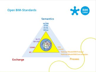
• facebook
  • Twitter
  • Linkedin
  • Youtube
  • Linkedin Group
  • Post a Job
  • Post an Ad
  • Post an Event
  • Post a Directory Listing
  • Post a Press Release
  • Media Kit
  • My Account
  • Login
GoGeomatics
  • MAGAZINE
    • BIM & GIS
    • Community
    • Conference news
    • Earth Observation
    • Education & Careers
    • GEOAI
    • Announcements
    • Reality Capture & Lidar
    • Science
    • Technology
    • Between the Poles
  • Directories
    • ASSOCIATION
    • INDUSTRY
    • EDUCATION
    • Open Data
  • EVENTS
    • GeoIgnite Events
    • Events Calendar
    • GoGeomatics Meetups
  • Services
    • Advertising
    • Marketing
    • Post a Job
    • Post an Ad
    • Post an Event
    • Post a Press Release
    • Post a Directory Listing
    • Media Kit
    • Web Design
  • Find a Job
  • Volunteer
    • Start a GoGeomatics Group
    • Editors & Writers Group
  • About Us
    • About Us
    • Contact Us
    • Frequently Asked Questions
  • Videos
HomeBetween the Poles – The Geoff Zeiss ArchivesConvergence

Convergence

3D data

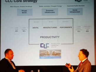
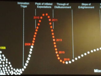
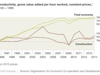
Intriguing new technology developments for improving construction productivity

9 October 2017 Geoff Zeiss

Throughout media day at the Year in Infrastructure 2017 (YII2017) conference I was on the edge of my chair because there were such tanatalizing hints of spatial technologies that might address major challenges of 21st […]

Between the Poles – The Geoff Zeiss Archives

Geospatial technology innovation is transformative

17 July 2017 Geoff Zeiss

Innovation in spatial technology is transforming some of the world’s most important economic sectors.  The world will need to spend $57 trillion on infrastructure through 2030 just to keep up with global GDP growth. To […]

3D data

Progress in advancing integrated BIM+geospatial standards for infrastructure

5 July 2017 Geoff Zeiss

There has been impressive progress in developing open standards for the integration of geospatial and AEC (architecture, engineering and constcruction) views of city infrastructure which provides a standards-based basis for full-lifecycle management from design through […]

3D data

BIM + geospatial essential for improving UK construction productivity

29 June 2017 Geoff Zeiss

At GeoBusiness 2017 in London, Simon Rawlinson of Arcadis, argued passionately for improving the efficency of the construction industry, which is 8% of the UK’s GDP.  Digitalization, in which BIM + geospatial play a key […]

3D data

Simplifying the integration of reality capture and asset management

24 May 2017 Geoff Zeiss

The construction industry in the UK, as in many of the world’s advanced economies, suffers from low productivity compared to other industries, a situation which hasn’t improved in 25 years according to Simon Rawlinson of […]

3D Visualization

Mixed reality in the construction industry is becoming a reality

13 April 2017 Geoff Zeiss

At the SPAR3D 2017 conference in Houston, I had the distinct feeling that we are on the cusp of an important inflection point where technology has evolved to the point that it is going to […]

Between the Poles – The Geoff Zeiss Archives

Digitization could boost construction productivity

6 March 2017 Geoff Zeiss

The CG/LA Infrastructure Leadership Forum in Montreal has provided a fascinating glimpse into what is happening around the world in infrastructure from a technology, financing, and business model perspective. From 50,000 feet the big item […]

No Picture
3D data

Developing a national 3D strategy in the Netherlands

8 December 2016 Geoff Zeiss

At the GeoBIM Building and Infrastructure Conference in Amsterdam Rob van de Velde and Friso Penninga of Geonovum presented an overview of what has been achieved to date with respect to 3D data and technology […]

Posts pagination

« 1 2 3 4 … 11 »

Events

Feb 25
All day

Government Cybersecurity Showcase Federal 2026

Mar 1
March 1 - March 4

PDAC Convention 2026

Mar 10
March 10 - March 13

2026 ABCLS Conference and 121st Annual General Meeting

Mar 24
6:00 pm - 8:00 pm

Calgary GoGeomatics March Social

Mar 31
March 31 - April 1

Geo Connect Asia 2026

View Calendar

View All Events

Services

  • Post a Job
  • Post an Ad
  • Post an Event
  • Post a Directory Listing
  • Post a Press Release
  • Media Kit
  • My Account
  • Login

Jobs

Post a Job
  • Volunteer Editorial Contributor – Be Part of Canada’s Geomatics Story
    Remote
  • Junior Geomatics Field Technician – Technical Surveys
    Montréal, QC
  • GIS Specialist
    Amherst, Nova Scotia
  • Precast Structural BIM Specialist
    Calgary, Alberta
View All Jobs
  • Directories
    • Associations Directory
    • Industry Directory
    • Education Programs
    • Open Data
  • Volunteer
    • Start a GoGeomatics Group
    • Editors & Writers Group
  • About Us
    • GoGeomatics Media Kit
    • Who We Are
    • Contact Us
    • FAQ’s
    • Advertising
    • Marketing
  • Subscribe
GoGeomatics
GoGeomatics is the largest and most popular communications hub promoting the Canadian geospatial community. The business was incorporated in 2011. GoGeomatics hosts over 100 fun, free, location technology networking events each year in cities across Canada.

© 2026 GoGeomatics

  • facebook
  • Twitter
  • Linkedin
  • Youtube
  • Linkedin Group