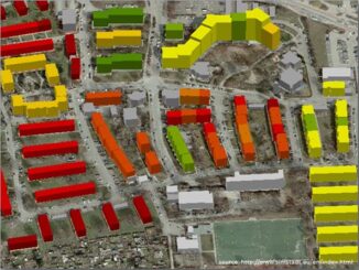
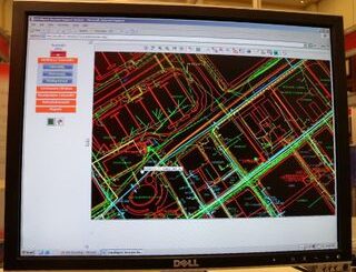
• facebook
  • Twitter
  • Linkedin
  • Youtube
  • Linkedin Group
  • Post a Job
  • Post an Ad
  • Post an Event
  • Post a Directory Listing
  • Post a Press Release
  • Media Kit
  • My Account
  • Login
GoGeomatics
  • MAGAZINE
    • BIM & GIS
    • Community
    • Conference news
    • Earth Observation
    • Education & Careers
    • GEOAI
    • Announcements
    • Reality Capture & Lidar
    • Science
    • Technology
    • Between the Poles
  • Directories
    • ASSOCIATION
    • INDUSTRY
    • EDUCATION
    • Open Data
  • EVENTS
    • GeoIgnite Events
    • Events Calendar
    • GoGeomatics Meetups
  • Services
    • Advertising
    • Marketing
    • Post a Job
    • Post an Ad
    • Post an Event
    • Post a Press Release
    • Post a Directory Listing
    • Media Kit
    • Web Design
  • Find a Job
  • Volunteer
    • Start a GoGeomatics Group
    • Editors & Writers Group
  • About Us
    • About Us
    • Contact Us
    • Frequently Asked Questions
  • Videos
HomeBetween the Poles – The Geoff Zeiss ArchivesDigital Cities

Digital Cities

3D data

Crossrail’s huge BIM+geospatial model targeted on operations and maintenance

4 April 2016 Geoff Zeiss

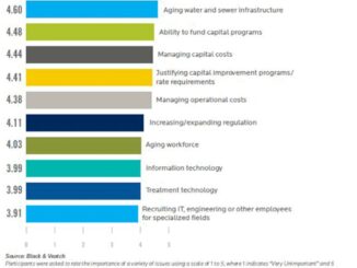
The UK Government as part of its building information modeling (BIM) initiative has said repeatedly that it expects the big payoff of a digital model, estimated at more than 40% savings, will be during operations and maintenance, […]

3D data

One third of Be Inspired Awards involve mapping, managing, rehabbing and replacing aging infrastructure

18 November 2015 Geoff Zeiss

Worldwide there is increasing demand from building and infrastructure owners for service provision throughout the entire life cycle of a building or infrastructure. This represents a distinct break with the design/build tradition which has dominated […]

Analytics

INSPIRE-Geospatial World Forum 2015 program released

11 March 2015 Geoff Zeiss

INSPIRE-Geospatial World Forum 2015, a joint conference organized by the European Commission and Geospatial Media and Communications, has made available its full conference program. Almost 500 presentations are scheduled on topics including building information modelling […]

3D printing

Smart cities market forecasted to reach over $ 1 trillion by 2019

23 December 2014 Geoff Zeiss

Urbanization is a worldwide phenomenon.  Smart city technology is becoming an essential element in the development of the world’s megacities.  For example, the new Indian government’s just released budget includes an allocation for initiating the […]

3D data

Urban planning working group announced by the Open Geospatial Consortium

21 August 2014 Geoff Zeiss

An Urban Planning Domain Working Group (DWG) has been chartered to define the role for Open Geospatial Consortium (OGC) standards within the urban planning discipline.  The DWG offers an open forum for the discussion and […]

3D data

Open standards-based foundation for integrating BIM, geospatial and smart meters for urban energy performance optimization

1 July 2014 Geoff Zeiss

The European Union has set itself aggressive goals to reduce GHG emissions by 20%, increase renewables share of energy generation to 20%, and to reduce energy consumption by 20% by 2020.  The EU seems to […]

No Picture
3D data

Standards for the convergence of BIM, 3D and geospatial

23 June 2014 Geoff Zeiss

At Geospatial World Forum 2014 in Geneva this year Leif Granhom, Senior Vice President at Tekla Finland gave an insightful presentation about the integration of building information modeling (BIM) and geospatial information.  An important part of […]

3D data

Comprehensive open city model for Bahrain includes underground infrastructure

2 June 2014 Geoff Zeiss

Locating underground infrastructure in Bahrain Bahrain is one of the few places in the world which attempts to maintain the location of all underground infrastructure in a single database.  As I blogged in 2009, the […]

Posts pagination

« 1 2 3 4 … 11 »

Events

Feb 24
5:30 pm - 7:30 pm

Kelowna Mural Map – User Feedback & Networking Social

Feb 24
6:30 pm - 8:30 pm

February Ottawa GoGeomatics Meetup

Feb 25
All day

Government Cybersecurity Showcase Federal 2026

Mar 1
March 1 - March 4

PDAC Convention 2026

Mar 10
March 10 - March 13

2026 ABCLS Conference and 121st Annual General Meeting

View Calendar

View All Events

Services

  • Post a Job
  • Post an Ad
  • Post an Event
  • Post a Directory Listing
  • Post a Press Release
  • Media Kit
  • My Account
  • Login

Jobs

Post a Job
  • Volunteer Editorial Contributor – Be Part of Canada’s Geomatics Story
    Remote
  • Junior Geomatics Field Technician – Technical Surveys
    Montréal, QC
  • GIS Specialist
    Amherst, Nova Scotia
  • Precast Structural BIM Specialist
    Calgary, Alberta
View All Jobs
  • Directories
    • Associations Directory
    • Industry Directory
    • Education Programs
    • Open Data
  • Volunteer
    • Start a GoGeomatics Group
    • Editors & Writers Group
  • About Us
    • GoGeomatics Media Kit
    • Who We Are
    • Contact Us
    • FAQ’s
    • Advertising
    • Marketing
  • Subscribe
GoGeomatics
GoGeomatics is the largest and most popular communications hub promoting the Canadian geospatial community. The business was incorporated in 2011. GoGeomatics hosts over 100 fun, free, location technology networking events each year in cities across Canada.

© 2026 GoGeomatics

  • facebook
  • Twitter
  • Linkedin
  • Youtube
  • Linkedin Group