• facebook
  • Twitter
  • Linkedin
  • Youtube
  • Linkedin Group
  • Post a Job
  • Post an Ad
  • Post an Event
  • Post a Directory Listing
  • Post a Press Release
  • Media Kit
  • My Account
  • Login
GoGeomatics
  • MAGAZINE
    • BIM & GIS
    • Community
    • Conference news
    • Earth Observation
    • Education & Careers
    • GEOAI
    • Announcements
    • Reality Capture & Lidar
    • Science
    • Technology
    • Between the Poles
  • Directories
    • ASSOCIATION
    • INDUSTRY
    • EDUCATION
    • Open Data
  • EVENTS
    • GeoIgnite Events
    • Events Calendar
    • GoGeomatics Meetups
  • Services
    • Advertising
    • Marketing
    • Post a Job
    • Post an Ad
    • Post an Event
    • Post a Press Release
    • Post a Directory Listing
    • Media Kit
    • Web Design
  • Find a Job
  • Volunteer
    • Start a GoGeomatics Group
    • Editors & Writers Group
  • About Us
    • About Us
    • Contact Us
    • Frequently Asked Questions
  • Videos
HomeOther

Other

Urban Digital Twin
Other

Beyond the Blueprint: Building Smarter Cities with Digital Twins

11 July 2025 Bruce Chaplin | 3D

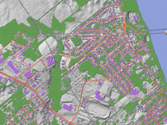
Cities are under pressure. Infrastructure is ageing, urban population is growing and climate risks are escalating. Urban planners are expected to manage this complexity — often with tools that were never designed for the pace […]

Other

‘We’re Losing Talent We Can’t Afford to Lose’: NAIT’s Patrick Whitehead on Geospatial Program Closures

4 July 2025 Anusuya Datta | alberta

In recent months, several Canadian colleges and universities have announced cuts to geospatial and geomatics programs, reflecting ongoing pressure on post-secondary institutions to make difficult decisions in response to shifting enrollment patterns and limited funding. […]

Other

Advancing Open-Source GIS: QGIS User Conference 2025 Recap

27 June 2025 David Legris | AI

The QGIS User Conference held June 2-3 brought together open-source GIS users and developers at Linköping University in Norrköping, Sweden. The QGIS User Conference is an annual gathering of GIS Professional and other QGIS users to […]

Earth Observation

Earth Observation, Data Access, and Domestic Capacity: Inside CSA’s 2025–26 Plan

22 June 2025 GoGeomatics Canada | Arctic monitoring

The Canadian Space Agency’s latest spending plan maintains steady funding across its core responsibilities, from satellite operations and space science to robotics and international programs. Within that broader mandate, the plan highlights ongoing investment in […]

Canada Map
Other

Geospatial Infrastructure: Canada’s Defense Strategy Ignores a Critical Layer

16 June 2025 Anusuya Datta | Arctic Security

Canada’s long-awaited defense policy update promises a long-overdue ramp-up in spending — reaching the NATO benchmark of 2% of GDP within a year. For a country that has historically lagged behind its allies in military […]

Other

Taking Control of Canada’s Digital Sovereignty with Open-Source GIS

10 June 2025 Anusuya Datta | Canada

(This is the second part of our series, following the article exploring France’s success with open-source GIS) Canada’s geospatial systems are at a crossroads. Technology is moving fast, and the pressure is on for more efficient, […]

VS
Conference news

A Lifetime in Radar: Dr. Vernon Singhroy on Innovation, Influence, and Mentorship

6 June 2025 Benedicta Antwi Boasiako | AI

Dr. Vernon Singhroy is Canada’s one of the most distinguished Earth Observation scientists, known globally for his expertise in Synthetic Aperture Radar (SAR) and remote sensing applications. Over his decades-long career, he has published more […]

GEOAI

GeoAI in Marine Monitoring: Can this Synergy Work?

28 May 2025 Alefiya Dungrawala | bathymetric surface

GeoAI is to use artificial intelligence (AI) in conjunction with geospatial data to address geographically oriented problems. The combination of GeoAI and marine is not as widespread as in other sectors. Though promising for environmental […]

Posts pagination

« 1 2 3 4 … 36 »

Events

May 25
May 25 - May 28

National Surveyors’ Conference 2026

May 27
May 27 @ 8:00 am - May 29 @ 5:00 pm

Canadian Cartographic Association Conference 2026

Jun 1
June 1 - June 4

CAG/CARTO Annual Meeting 2026

Jul 4
July 4 @ 8:00 am - July 11 @ 5:00 pm

ISPRS Congress 2026

Sep 15
September 15 - September 17

INTERGEO 2026

View Calendar

View All Events

Services

  • Post a Job
  • Post an Ad
  • Post an Event
  • Post a Directory Listing
  • Post a Press Release
  • Media Kit
  • My Account
  • Login

Jobs

Post a Job
  • Geospatial Analytical Technician / Technicien, analyses géospatiales; technicienne, analyses géospatiales
    Peterborough
  • GIS Technologist II
    Fernie, B.C.
  • GIS I TECHNOLOGIST
    Fernie, B.C.
  • Building Science and Restoration CAD/BIM Technologist
    Vancouver
View All Jobs
  • Directories
    • Associations Directory
    • Industry Directory
    • Education Programs
    • Open Data
  • Volunteer
    • Start a GoGeomatics Group
    • Editors & Writers Group
  • About Us
    • GoGeomatics Media Kit
    • Who We Are
    • Contact Us
    • FAQ’s
    • Advertising
    • Marketing
  • Subscribe
GoGeomatics
GoGeomatics is the largest and most popular communications hub promoting the Canadian geospatial community. The business was incorporated in 2011. GoGeomatics hosts over 100 fun, free, location technology networking events each year in cities across Canada.

© 2026 GoGeomatics

  • facebook
  • Twitter
  • Linkedin
  • Youtube
  • Linkedin Group