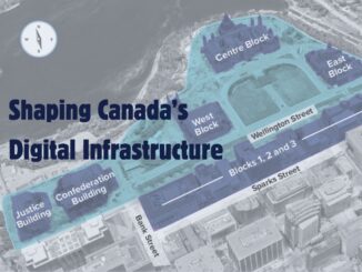
• facebook
  • Twitter
  • Linkedin
  • Youtube
  • Linkedin Group
  • Post a Job
  • Post an Ad
  • Post an Event
  • Post a Directory Listing
  • Post a Press Release
  • Media Kit
  • My Account
  • Login
GoGeomatics
  • MAGAZINE
    • BIM & GIS
    • Community
    • Conference news
    • Earth Observation
    • Education & Careers
    • GEOAI
    • Announcements
    • Reality Capture & Lidar
    • Science
    • Technology
  • Directories
    • ASSOCIATION
    • INDUSTRY
    • EDUCATION
    • Open Data
  • EVENTS
    • GeoIgnite Events
    • Events Calendar
    • GoGeomatics Meetups
  • Services
    • Advertising
    • Marketing
    • Post a Job
    • Post an Ad
    • Post an Event
    • Post a Press Release
    • Post a Directory Listing
    • Media Kit
    • Web Design
  • Find a Job
  • Volunteer
    • Start a GoGeomatics Group
    • Editors & Writers Group
  • About Us
    • About Us
    • Contact Us
    • Frequently Asked Questions
  • Videos
HomeScience

Science

|labour NOC|Data challenges NOC
BIM & GIS

Canada’s Blind Spot: The Government Can’t See Its Own Geospatial Sector

24 April 2025 Anusuya Datta | business

Canada’s geomatics and geospatial sector touches nearly every area of national interest — from infrastructure development and resource mapping to climate monitoring, emergency response, and public safety. It underpins smart cities, clean energy, transportation, and […]

NG911|The Transition Timeline
BIM & GIS

Canada’s Next-Gen 9-1-1: The Upgrade Depends on the Maps You Don’t See

22 April 2025 Anusuya Datta | Canada Emergency Response

When Canadians dial 9-1-1 today, they expect to speak with someone who can send help. This voice-based system has served us for decades. But major changes are coming. Canada is replacing its legacy emergency system with Next […]

||
Community

European State of the Climate: Extreme Events in Warmest Year on Record

21 April 2025 Charles Duncan | climate

A recent report on the European State of the Climate issued by the Copernicus Climate Change Service and the World Meteorological Organization highlights that Europe experienced its warmest year on record in 2024, which was […]

International Digest April 21||||
Community

International Geospatial Digest – April 21, 2025

21 April 2025 Volunteer Editors and Group Writers | AI

Meet Biomass, the Satellite Measuring the Carbon Content of Rainforests Google and AI – Geospatial Reasoning Mapping Seagrass Along the Italian Coast with Airborne Lidar Bathymetry Idea to Capture Vanguard-1, a Satellite from 1958 Senegal […]

Back to School Social Calgary|JM-geomatics education||what canada needs
Community

Treat Geomatics Like a National Asset, Not an Afterthought

17 April 2025 Jon Murphy | Applied Learning

Across Canada, geomatics and geospatial education are facing a reckoning. Programs are shrinking or disappearing altogether, funding is increasingly scarce, and institutions are being forced to make difficult decisions about what to sustain. Meanwhile, the […]

|Beluga whales|Beluga Whales2|Beluga whales3
BIM & GIS

AI Meets Beluga Whales in the Arctic

17 April 2025 Anusuya Datta | AI in Conservation

Flying over Arctic waters, you’d never spot them. Beluga whales vanish against the ice below — their white bodies nearly invisible from above. Fisheries and Oceans Canada (DFO) has always watched these animals closely. For […]

|||
Earth Observation

Navigating the Dangers of Congested Orbital Space

14 April 2025 Alefiya Dungrawala | cascading impact

Is outer space too vast to be polluted? Will it eventually self-clean? Let us not forget that humans have a tendency to spread pollution. What we observe around us serves as the most profound silent […]

Canadian-digest-April-14|
Earth Observation

Canadian Geospatial Digest – April 14, 2025

14 April 2025 Volunteer Editors and Group Writers | Canada

Wildlife Without Borders: Cross-Border Conservation Under Threat Drones for Disaster: UVic’s Smart Mapping Tool Takes Flight Canada’s Weather Map Flips: Arctic Warmer Than Southern Ontario Restoring the Past: Tremaine Map of Upper Canada Now on […]

Posts pagination

« 1 … 9 10 11 … 14 »

Events

Notice
There are no upcoming events.

View All Events

Services

  • Post a Job
  • Post an Ad
  • Post an Event
  • Post a Directory Listing
  • Post a Press Release
  • Media Kit
  • My Account
  • Login

Jobs

Post a Job
  • Canada Maps and Poster Gallery Volunteer Leads — GeoIgnite 2026
    remote
  • GIS & Data Analytics Lead
    Beaumont, AB
  • Lead Surveyor, Projects/Arpenteur-géomètre principal, projets; arpenteuse-géomètre principale, projets
    North Bay, Thunder Bay
  • Senior GIS Developer
    Calgary, AB
View All Jobs
  • Directories
    • Associations Directory
    • Industry Directory
    • Education Programs
    • Open Data
  • Volunteer
    • Start a GoGeomatics Group
    • Editors & Writers Group
  • About Us
    • GoGeomatics Media Kit
    • Who We Are
    • Contact Us
    • FAQ’s
    • Advertising
    • Marketing
  • Subscribe
GoGeomatics
GoGeomatics is the largest and most popular communications hub promoting the Canadian geospatial community. The business was incorporated in 2011. GoGeomatics hosts over 100 fun, free, location technology networking events each year in cities across Canada.

© 2025 GoGeomatics

  • facebook
  • Twitter
  • Linkedin
  • Youtube
  • Linkedin Group