• facebook
  • Twitter
  • Linkedin
  • Youtube
  • Linkedin Group
  • Post a Job
  • Post an Ad
  • Post an Event
  • Post a Directory Listing
  • Post a Press Release
  • Media Kit
  • My Account
  • Login
GoGeomatics
  • MAGAZINE
    • BIM & GIS
    • Community
    • Conference news
    • Earth Observation
    • Education & Careers
    • GEOAI
    • Announcements
    • Reality Capture & Lidar
    • Science
    • Technology
    • Between the Poles
  • Directories
    • ASSOCIATION
    • INDUSTRY
    • EDUCATION
    • Open Data
  • EVENTS
    • GeoIgnite Events
    • Events Calendar
    • GoGeomatics Meetups
  • Services
    • Advertising
    • Marketing
    • Post a Job
    • Post an Ad
    • Post an Event
    • Post a Press Release
    • Post a Directory Listing
    • Media Kit
    • Web Design
  • Find a Job
  • Volunteer
    • Start a GoGeomatics Group
    • Editors & Writers Group
  • About Us
    • About Us
    • Contact Us
    • Frequently Asked Questions
  • Videos
HomeScience

Science

digital sovereignty
Community

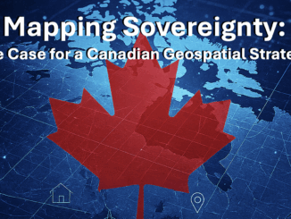
Before It’s Too Late: Carina Butterworth on Reclaiming Canada’s Digital Sovereignty Through Education

16 October 2025 Carina Butterworth | business

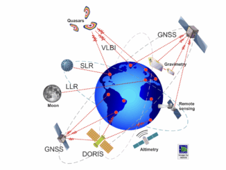
Dr. Tracey Lauriault’s recent interview, Before It’s Too Late: Canada’s Data Sovereignty Crisis, struck a chord with me. Her message about the risks of losing control over Canada’s geospatial data — and the need to […]

Earth Observation

Canada’s Geodesy Void and the Hidden Risks to Economy, Defence, and Sovereignty

13 October 2025 Anusuya Datta | Canada

Canada’s failure to invest in modern geodetic infrastructure has left it dependent on foreign systems to run satellites, guide ships, synchronize power grids, and safeguard sovereignty — an invisible weakness in the infrastructure that holds […]

BIM & GIS

Canada’s Climate Progress Flatlines: Emissions Stagnate in 2024

9 October 2025 Alefiya Dungrawala | 440 mega tonnes

Reaching net-zero emissions means that Canada’s economy either produces no greenhouse gases or offsets any emissions through actions such as planting trees or using carbon capture technologies. Achieving net-zero is essential to ensure a safe […]

Tracey Lauriault
BIM & GIS

“Before It’s Too Late”: Tracey Lauriault on Canada’s Data Sovereignty Crisis

9 October 2025 Anusuya Datta | Artificial Intelligence

Digital sovereignty has quickly become one of the most pressing policy issues in Canada. From the U.S. Patriot Act and Cloud Act to the risks of foreign ownership of critical infrastructure, Canada finds itself increasingly […]

Canada Geospatial Strategy
BIM & GIS

Canada Has an AI Strategy. Why Not a Geospatial One?

8 October 2025 Anusuya Datta | Arctic

Canada has shown it can move fast when it decides something matters. Artificial intelligence is the proof. The Pan-Canadian AI Strategy, launched in 2017, was the world’s first funded national AI strategy. It built a […]

OGC Canada Forum
BIM & GIS

GoGeomatics and OGC Announce Partnership to Advance Canada’s Geospatial Community

7 October 2025 GoGeomatics Canada | business

GoGeomatics Canada and the Open Geospatial Consortium (OGC) are pleased to announce a new three-year partnership to strengthen collaboration and knowledge-sharing across Canada’s geospatial sector. Under this agreement, OGC will sponsor and co-develop the OGC […]

Award winners
BIM & GIS

Final Results In: These Are the Winners of Canada’s National Geomatics Awards 2025

3 October 2025 GoGeomatics Canada | Applied Geomatics Research Group (AGRG)

The winners of the Canada’s National Geomatics Awards 2025 have been announced, recognizing leadership, innovation, and community impact across the country’s geomatics and geospatial sector. Launched to highlight outstanding contributions, the National Geomatics Awards honour […]

Earth Observation

Attribution Science: Canada’s Fast-Track Tool for Understanding Extreme Weather

26 September 2025 Alefiya Dungrawala | attribution science

“The rate of temperature warming in Canada exceeds the global average.” Canada’s summer of 2025 not only broke temperature records but also reshaped the landscape of climate extremes in Canada. From the blazing forest fires […]

Posts pagination

« 1 … 3 4 5 … 15 »

Events

Jul 4
July 4 @ 8:00 am - July 11 @ 5:00 pm

ISPRS Congress 2026

Sep 15
September 15 - September 17

INTERGEO 2026

Sep 16
September 16 - September 17

Join ALL IN 2026, Montreal, Canada

Oct 26
October 26 - October 28

Canada’s National Geomatics Expo 2026

Oct 27
October 27 - October 29

Rendez-vous Géomatique 2026

View Calendar

View All Events

Services

  • Post a Job
  • Post an Ad
  • Post an Event
  • Post a Directory Listing
  • Post a Press Release
  • Media Kit
  • My Account
  • Login

Jobs

Post a Job
  • GIS Analyst
    Saint John, New Brunswick
  • GIS Student Intern
    Elmsdale, Nova Scotia
  • Canada Impact+ Research Chair – Professor (Or Associate Professor)
    Lethbridge, Alberta
  • Leader, Utilities Surveying
    Calgary, Alberta
View All Jobs
  • Directories
    • Associations Directory
    • Industry Directory
    • Education Programs
    • Open Data
  • Volunteer
    • Start a GoGeomatics Group
    • Editors & Writers Group
  • About Us
    • GoGeomatics Media Kit
    • Who We Are
    • Contact Us
    • FAQ’s
    • Advertising
    • Marketing
  • Subscribe
GoGeomatics
GoGeomatics is the largest and most popular communications hub promoting the Canadian geospatial community. The business was incorporated in 2011. GoGeomatics hosts over 100 fun, free, location technology networking events each year in cities across Canada.

© 2026 GoGeomatics

  • facebook
  • Twitter
  • Linkedin
  • Youtube
  • Linkedin Group