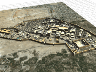
3D Reconstructions of Ancient Cities
As cities grow outwards and upwards over time, we most often forget what lies underneath what is on top. While not all cities from Antiquity have survived into the present day, the ones that have […]
Leverage tech for the public at GeoIgnite A new article on GeoIgnite 2019 in the Ottawa Business Journal highlights the “Geospatial Foundations” aspect that provided the framework for how the whole conference came together—that is, […]
GeoIgnite features plenary speaker from the OGC GeoIgnite is packing its schedule with plenary speakers who also happen to be leaders in the international geospatial community. Nadine Alameh of the Open Geospatial Consortium has recently […]
FDNY geospatial mapping used to reach opioid overdose cases Nurses and nursing students are using local, real-time maps of opioid overdoses to guide their work in community health settings. The Fire Department of New York […]
Natural Resources Canada (NRCan) is increasing the HRDEM product coverage by 30,000 km2 by publishing 21 new datasets in six provinces (BC, SK, MB, ON, QC, NB). This new publication of the HRDEM product adds […]
AT&T prepares for 5G 5G is part of an oncoming data storm. 5G will be connected to autonomous cars, robotic factories, and seamless AR/VR, and it will require a faster, more efficient network. To that […]
My previous article discussed the collection of non-spatial data. I’ll now introduce the concepts of collecting spatial data alongside it and making it automatically accessible through web maps. The Plan Hundreds, if not thousands, of […]
The new Canadian Air Regulations are complex pieces of literature for those unable to parse legalese. Luckily David Cooke, Chief Pilot of Cooke & Associates Inc., has taken the initiative to create a plain language […]