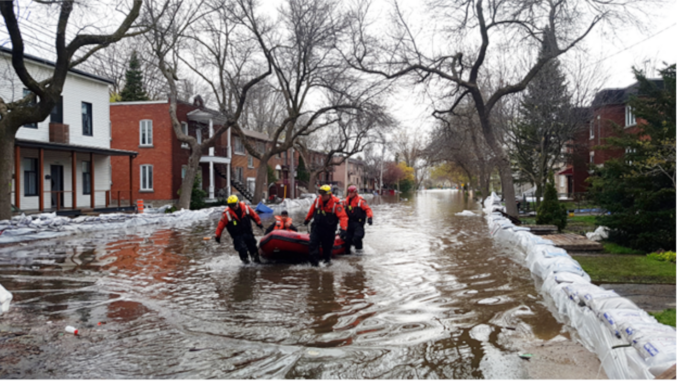
Over the past several years Quebec has been impacted by multiple severe flood events. In 2017 and 2019 much of southern Quebec was flooded and thousands of people were forced to leave their homes. More recently, floods in 2023 resulted in almost $2.5 billion dollars in insured damages. In response to these recurring and costly events, the province of Quebec is releasing a new generation of flood maps.
The new maps are currently being produced by the provincial and municipal governments and are expected to be released on a rolling basis starting in March 2026, replacing the old maps as they are released.
A more detailed analysis of flood risks in Quebec
The province’s current flood maps incorporate two levels of flood risk: higher risk zones that have a greater than 5% chance of being flooded each year, including all areas affected by ice jam floods, and lower risk zones that have between a 1% and 5% chance of flooding annually. The new maps represent a more nuanced and scientifically rigorous approach to flood mapping.

They incorporate four levels of flood risk (from low to very high) based on a combination of the expected height of flood waters in a given area and the percent chance that an area will flood over a period of 25 years, and will also include maps for zones of predicted river channel movement.
Creating the maps
The process of creation for the maps is described in detail in a set of methodological guides produced for engineers and scientists, cartographers, and policy makers. A variety of factors are taken into account, including current and historical flood frequency and intensity and how these patterns are likely to change due to climate change, river channel movement, the occurrence of ice jams, and the presence of dams and flood protection measures like dykes and floodwalls.
The first step in the process is to conduct an assessment of a watershed and, given the vast extent of many watersheds in Quebec, determine which areas should be prioritized in terms of mapping due to higher population density and flood risk. Then, the various types of flood risks are analyzed for that watershed. Also, open water flood risks are estimated, and hydrodynamic simulations are conducted based on these estimations and the effects of flood protection works and anthropogenic modifications on a river’s hydrology. Other risks, including ice jam floods and channel mobility are then also assessed.
All risk types are assessed in the current climate, as well as in the context of climate change using advanced climate models to determine how river discharges may change in the future. After the level of each risk type is determined and mapped, they are combined into a single flood map.
Mapping river channel mobility
Not only will new flood maps be released in 2026, but for the first time there will be official government maps showing the risk of river channel movement. Channel movement can occur in several ways. Rivers can widen when erosion occurs on both banks, a meandering river will change gradually as erosion occurs on the outer banks of river bends and sediment is deposited on the inner banks, a river may completely change its course in what is called an avulsion, and vertical modifications to a river’s profile occur when there is erosion or deposition of large amounts of sediment on the river’s bed.
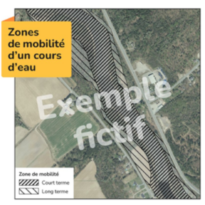
To assess river channel movement, areas that the river channel has previously occupied and past rates of river channel movement are determined using historical aerial imagery, and these rates are projected into the future. These projected rates are used to predict channel movement over the short-term (50 years) as well as in the long-term over the course of several generations.
New policy on the management of flood zones and riverine environments
Changes to Quebec’s flood maps will also be accompanied by changes to the province’s policy on flood protection measures and the management of flood, mobility, and littoral zones. These changes aim to decrease the risks posed by flooding by better protecting people, infrastructure and riverine ecosystems. They include new rules on the construction of buildings in littoral zones, and rules on the construction, management and maintenance of flood protection measures, as well as modifications to rules concerning activity in littoral zones and environmental impact assessments. Municipalities will also be required to conduct assessments of existing flood protection measures in their territory to ensure their effectiveness.
Financial implications of the improved flood maps
With these new changes, there is expected to be 30% more homes found in flood zones than there was previously. In accordance with the new rules, new construction is not allowed in the highest risk flood zone and homes that are destroyed can not be rebuilt, however residents are allowed to renovate their homes to make them more resilient to floods and will not be forced to move. There has been concern from some municipalities over the new maps lowering property values and increasing insurance prices, however the Quebec government assures that these updates are necessary. Some of the existing flood maps are decades out of date, making updates crucial.
More accurate and detailed maps are now possible with the use of models and data, including advanced climate models, LiDAR and detailed bathymetric data, that did not exist when many of the original maps were created.
With the frequency and intensity of floods increasing as the climate changes, the identification and proper management of flood zones is crucial to preventing costly damages and creating communities resilient to floods.
Radio-Canada 2024 Scientist of the Year award
Hundreds of scientists in Quebec across many disciplines, including engineering, climatology, hydrology, hydrogeomorphology and geomatics, have been working for many years on the new maps and methodology. Among these hundreds of scientists, four representatives were chosen as recipients of Radio-Canada’s 2024 Scientist of the Year award. The four scientists are Thomas Buffin-Bélanger, professor of hydrogeomorphology at the Université du Québec à Rimouski (UQAR), Mélanie Trudel, professor in the department of civil and building engineering at Université de Sherbrooke, Richard Turcotte, science advisor at the Ministry of Environment, Fight Against Climate Change, Wildlife and Parks, and Louis-Philippe Caron, climate researcher and head of the Scenarios and Climate Services group at Ouranos.


The Province of Quebec’s updated policy on flood zone and riverine environment management highlights a necessary and long-overdue shift toward evidence-based flood risk assessment. As noted, many existing flood maps were produced decades ago using limited data and static methods that could not account for changing hydrological conditions, evolving river morphology, or the accelerating impacts of climate change.
Advances in geospatial technology now make it possible to produce significantly more accurate and defensible flood maps. Using high-resolution LiDAR data from the Federal Government, with vertical accuracies of approximately 30 cm, combined with neural-network and supervised classification techniques, SAR datasets, and hydrological modelling, river-level rise can be simulated with far greater precision. These methods allow for the reliable delineation of 1-in-10, 1-in-50, and 1-in-100-year flood extents, as well as the analysis of future flood scenarios.
Through the simulation of flood extents, it is also possible to identify individual properties at risk with a high degree of confidence. By integrating three-dimensional building footprints and elevation data, flood impacts can be assessed at the structure level, including the depth and extent of inundation affecting specific buildings. This approach provides a more realistic representation of flood risk than traditional two-dimensional mapping and supports targeted mitigation, emergency planning, and informed decision-making for property owners and municipalities.
Beyond flood extent mapping, classification techniques enable the detection of sediment movement, riverbank change, and broader geomorphological evolution over time—critical factors in understanding flood behaviour and the long-term effectiveness of flood protection measures. This is particularly relevant given the new requirement for municipalities to assess existing flood mitigation infrastructure and ensure it remains effective under changing conditions.
While concerns regarding property values and insurance costs are understandable, the identification of an increased number of homes within flood zones reflects improved accuracy rather than increased risk. More precise maps provide municipalities, residents, and insurers with a clearer understanding of actual exposure, enabling informed decision-making, targeted mitigation measures, and the development of more resilient communities.
As flood frequency and intensity continue to rise, the ability to produce accurate, dynamic flood maps and to simulate future flood scenarios is no longer optional—it is essential. Modern data-driven flood mapping supports public safety, responsible land-use planning, environmental protection, and long-term economic resilience, aligning directly with the objectives outlined in Quebec’s updated flood management framework.