• facebook
  • Twitter
  • Linkedin
  • Youtube
  • Linkedin Group
  • Post a Job
  • Post an Ad
  • Post an Event
  • Post a Directory Listing
  • Post a Press Release
  • Media Kit
  • My Account
  • Shopping Cart
  • Login
GoGeomatics
  • MAGAZINE
    • BIM & GIS
    • Community
    • Conference news
    • Earth Observation
    • Education & Careers
    • GEOAI
    • Announcements
    • Reality Capture & Lidar
    • Science
    • Technology
    • Between the Poles
  • Directories
    • ASSOCIATION
    • INDUSTRY
    • EDUCATION
    • Open Data
  • EVENTS
    • GeoIgnite Events
    • Events Calendar
    • GoGeomatics Meetups
  • Services
    • Advertising
    • Marketing
    • Post a Job
    • Post an Ad
    • Post an Event
    • Post a Press Release
    • Post a Directory Listing
    • Media Kit
    • Web Design
  • Find a Job
  • Volunteer
    • Start a GoGeomatics Group
    • Editors & Writers Group
  • About Us
    • About Us
    • Contact Us
    • Frequently Asked Questions
  • Videos
HomeQuebec

Quebec

Earth Observation

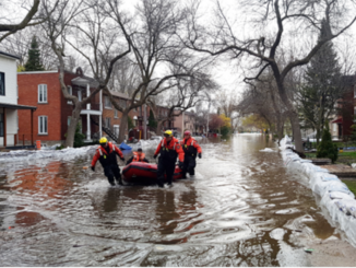
Across Canada, Provinces Step Up for Wildfire Season

21 April 2026 Alefiya Dungrawala | British Columbia

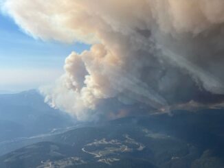
As climate patterns shift, Canada’s wildfire season is growing longer and more severe. After devastating seasons in 2023, 2024, and 2025, provinces are ramping up preparedness efforts. With ongoing drought in northwestern regions and a […]

Community

Canadian Geospatial Digest – February 23, 2026

23 February 2026 Volunteer Editors and Group Writers | Canada Defence Industrial Strategy

Canada launches first defence industrial strategy Quebec’s plan for digital sovereignty Dynamic Map Platform’s coast-to-coast coverage of Canadian roads Natural Resources Canada adds to existing flood event datasets NRCan-TAP: A partnership for building sustainable communities […]

BIM & GIS

Mapping a More Resilient Future: A Look at Quebec’s New Generation of Floods Maps

5 January 2026 Gisela Grossman | 2023 Quebec Flood

Over the past several years Quebec has been impacted by multiple severe flood events. In 2017 and 2019 much of southern Quebec was flooded and thousands of people were forced to leave their homes. More […]

Montreal's GNSS stations
Earth Observation

Pride in Precision: Montreal’s Real-Time GNSS Network and Its Legacy

22 September 2025 Benedicta Antwi Boasiako | Canadian geodetic survey

When Montréal switched on its Real-Time GNSS Network (RTN), it marked a milestone in Canadian geodesy. By deploying its own standards-compliant GNSS infrastructure, Montréal stands among the pioneering Canadian cities offering centimeter-level positioning accuracy across […]

BIM & GIS

How to Bridge Reality and Digital Space – A Conversation with John Hale

27 July 2025 David Legris | #buildingSMARTCanada

Canada’s progress on Building Information Modelling (BIM) standardization and alignment with other spatial technologies has been steadily improving through the work of organization like buildingSMART Canada. Helping to lead this change is John Hale, the […]

Community

Canadian Geospatial Digest June 23, 2025

23 June 2025 Volunteer Editors and Group Writers | Charter

UBC Okanagan Student Develops Canadian Wildfire Application Flood Mapping will Increase the Number of Quebec Homes in Flood Zones A New Digital Mapping Tool for Ottawa’s Traffic Infrastructure New RFP from the Canada Govt Looks […]

Canadian-digest-March-31|||||
Earth Observation

Canadian Geospatial Digest – March 31, 2025

31 March 2025 Volunteer Editors and Group Writers | algorithm

IceMAP-R – A new algorithm to monitor river ice in Quebec Halifax gets the most accurate floodplain map for Sackville River An interactive grid capacity map for Toronto Hydro, Ontario Arctic Over-the-Horizon Radar : A […]

Technology

NV5 Geospatial Collaborates with Communauté métropolitaine de Québec on Ambitious Topobathymetric Lidar Survey

3 August 2023 Sven Cowan | Canada

The earliest French settlers in North America were drawn in the 16th century to the area now known as Québec City, which sits on the north bank of the Saint Lawrence River and is home […]

Posts pagination

1 2 … 10 »

Events

Notice
There are no upcoming events.

View All Events

Services

  • Post a Job
  • Post an Ad
  • Post an Event
  • Post a Directory Listing
  • Post a Press Release
  • Media Kit
  • My Account
  • Shopping Cart
  • Login

Jobs

Post a Job
  • GIS SYSTEMS SPECIALIST
    Yellowknife, NT
  • Cartographic Analytical Technician / Technicien, analyses cartographiques; technicienne, analyses cartographiques
    Peterborough
  • Survey Technicians (Field and Office)
    Calgary, Alberta
  • Volunteer Editorial Contributor – Be Part of Canada’s Geomatics Story
    Remote
View All Jobs
  • Directories
    • Associations Directory
    • Industry Directory
    • Education Programs
    • Open Data
  • Volunteer
    • Start a GoGeomatics Group
    • Editors & Writers Group
  • About Us
    • GoGeomatics Media Kit
    • Who We Are
    • Contact Us
    • FAQ’s
    • Advertising
    • Marketing
  • Subscribe
GoGeomatics
GoGeomatics is the largest and most popular communications hub promoting the Canadian geospatial community. The business was incorporated in 2011. GoGeomatics hosts over 100 fun, free, location technology networking events each year in cities across Canada.

© 2026 GoGeomatics

  • facebook
  • Twitter
  • Linkedin
  • Youtube
  • Linkedin Group