
A Follow-Up to July’s Anticipation
As previously reported in GoGeomatics’ July 2025 International Geospatial Digest, the NASA–ISRO Synthetic Aperture Radar (NISAR) mission was launched with great anticipation as one of the most powerful Earth-observing radar satellites ever placed in orbit. At the time, it was still awaiting activation. Now, just two months later, we have the first proof of what the satellite can do.
NASA officially released NISAR’s first radar images of Earth on September 25, 2025, captured using its L-band Synthetic Aperture Radar (SAR). These preliminary images offer not just visual excitement but a demonstration of how radar-based Earth observation will reshape everything from agriculture and disaster monitoring to infrastructure planning and environmental resilience.
First Image — Mount Desert Island, Maine
Visualizing Land Use Through Radar
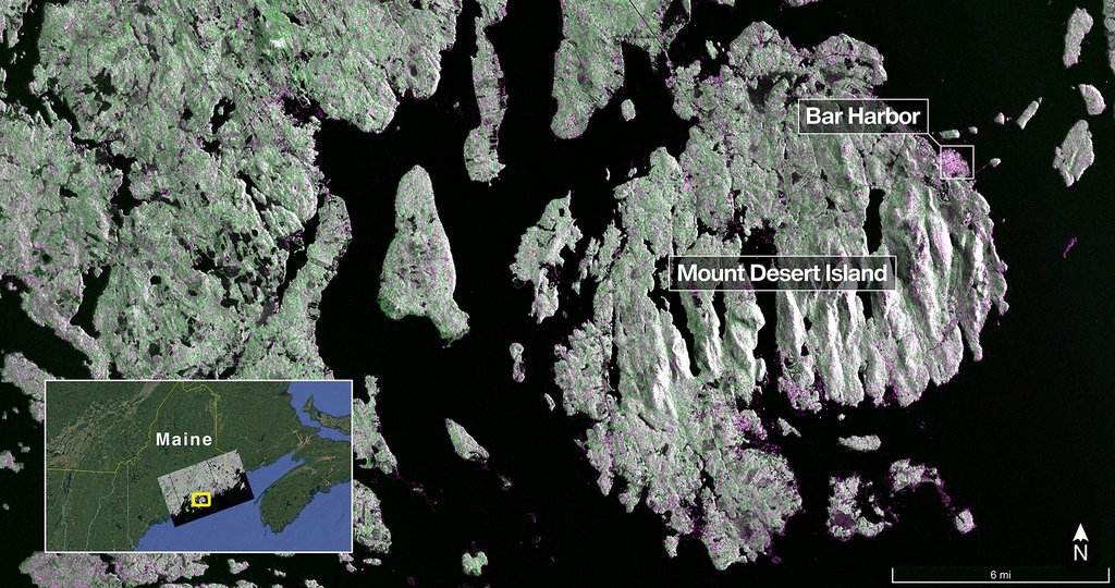
The first released image shows Mount Desert Island on the coast of Maine. In radar terms:
- Green = Forest cover
- Magenta = Hard surfaces and built environments (e.g., Bar Harbor)
- Dark = Water bodies
Even without optical color, human settlements become instantly visible, notably Bar Harbor, glowing in magenta on the island’s northeastern section. Narrow waterways and small offshore islets are captured with surprising clarity, showing NISAR’s ability to detect fine terrain features even under cloud cover or low light conditions.
Second Image — Forest River Region, North Dakota
Agriculture and Wetland Monitoring From Space
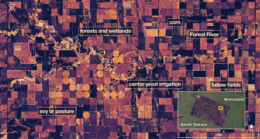
Just two days later, NISAR captured its second public image over Grand Forks and Walsh counties in North Dakota. Here, SAR imaging demonstrates its practical power:
- Dark fields indicate fallow or dry agricultural plots
- Lighter tones represent active croplands (likely soy and corn) or pastureland
- Circular shapes mark center-pivot irrigation systems
- Lighter blotches along the river reveal wetlands and riparian vegetation
This image alone shows how radar data can be used to monitor crop health, detect irrigation coverage, identify flood-prone zones, and assess water retention across landscapes.
Why Radar Changes the Game
Unlike optical satellites, NISAR’s L-band radar operates day and night, penetrating cloud cover, vegetation, and light soil. That makes it particularly valuable in regions where monsoons, snow cover, or smoke hinder traditional imagery.
Key use cases already being highlighted include:
- Disaster Response: Flood extent and landslide detection
- Agriculture: Crop moisture analysis and irrigation monitoring
- Infrastructure Safety: Tracking subsidence, deforestation, and land deformation
- Climate Observation: Glacier retreat and wetland shrinkage
A Model for Global Collaboration
The mission also stands out for its equal partnership between India and the United States. While NASA developed the L-band radar, ISRO contributed the S-band radar, satellite bus, and launch vehicle (GSLV-F16) — all documented in ISRO’S official mission overview. Together, the dual-band configuration offers unmatched precision in measuring surface deformation and biomass change at a global scale.
NASA officials, including acting Administrator Sean Duffy, praised the mission as a “testament to what can be achieved when nations unite around innovation.”
What Comes Next
These first images are only engineering test outputs. Full dual-band science operations will begin later this year, providing continuous surface-change data at a resolution of 5–10 meters, enough to track ground shifts, crop cycles, and even slow-moving landslides.
When the July digest first mentioned NISAR, it was framed as a promise. Now, with these images, that promise is turning into proof.
The question ahead is no longer “What can radar see?” — but rather: How will governments, scientists, and communities use this data to build a more resilient and better-planned world?
Stay tuned to GoGeomatics for more mission updates and radar insights as NISAR moves into full science operations.


Be the first to comment