
Natural Resources Canada has unveiled the WildFireSat e-Bulletin, a new periodic update that highlights developments in Canada’s satellite mission dedicated to monitoring wildland fires.
WildFireSat is poised to become the world’s first purpose-built operational satellite system for detecting and characterizing wildfires across Canada — delivering near-real-time fire data, twice daily. The e-Bulletin will serve as a bridge between the mission’s scientific and technical progress and the needs of Canada’s fire management agencies by sharing updates on design, implementation, data products, and user engagement.
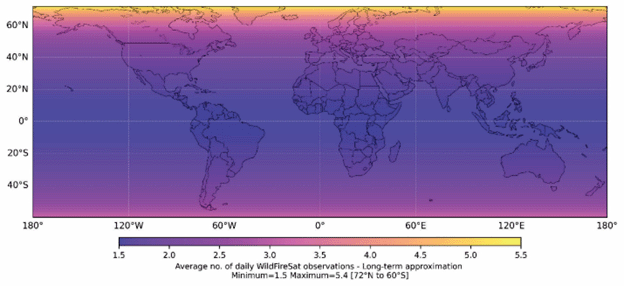
WildFireSat is a planned constellation of 7 microsatellites, which, when in operation, will provide daily wildfire monitoring. WildFireSat is a polar-orbiting constellation, providing frequent coverage for northern latitude areas, such as Canada. The constellation has been planned to pass over Canada frequently, providing coverage for the entire territory at least twice per day. Northern areas in Canada will receive more frequent coverage.
Once operational, WildFireSat will collect wildfire data for all areas of Earth – not only Canada – serving as a tool for global wildfire management. Due to its polar orbit, far northern areas – such as northern Canada – will receive coverage roughly 4 times per day, while areas near the equator will receive coverage roughly 1.5 times per day.
The team behind WildFireSat has been and continues to work alongside the Canadian public. In June, the WildFireSat team participated in the Arctic Development Expo in Inuvik, Northwest Territories, where they met with members of northern communities and local fire managers. Within the e-Bulletin is a selection of publications related to the application of WildFireSat, technical specifications of the mission, workshops, and other discussions related to the project. Lastly, fire management professionals are encouraged to share their perspective through a survey, which can be accessed through the e-Bulletin.


Be the first to comment