
The need for rapid response to devastating natural disasters has always existed, but technological limitations have gotten in the way in the past. However, with the rapid development in Earth Observation capabilities in recent times, there is more data available faster than ever before to be consumed, analyzed, and transformed into actionable intelligence for emergency management teams around the country. The purpose of a good GIS, after all, is to collect data, add context in the form of location and attribute information, and be the foundation for informed decision-making processes.
The scale and rapid development of natural disasters have typically hindered the real-time impact GIS and geospatial technologies could have on these situations. However, new developments in the temporal, spatial and spectral resolution of earth observation platforms, and their expert users, are leading to incredible advancements that are providing new insight and analysis that are at the forefront of a changing emergency management approach.
The need for federal geospatial expertise
While most natural disasters occur on small to regional scales, the authorities in these sometimes-remote jurisdictions can sometimes be overwhelmed by the magnitude of these events and require assistance from provincial or federal government. At NRCan, a team of geospatial scientists have created the Canadian Centre for Mapping and Earth Observation’s Emergency Geomatics Service as a resource to be called upon when the need for geospatial expertise outpaces regional or provincial resources. At GeoIgnite 2025, Simon Tolszczuk-Leclerc demonstrated the capabilities of the EGS in an informative and demonstrative way, as you will see in many of the examples that follow.
The EGS defines itself as ‘a critical service providing satellite-based mapping and geospatial analysis to support emergency disaster response and monitoring’. They work with federal resources and industry partners to provide enhanced situational awareness when called upon, by providing accurate, near real-time, satellite-based geospatial information. This involves accessing critical information from many both private and public satellites, including LANDSAT, Sentinel, RADARSAT, while also working with Capella Space, MDA, MAXAR, and Planet, to name a few industry partners. They acknowledge a growth in demand for this type of service as Canada tries to leverage satellite-based earth observation more fully.
Primary applications
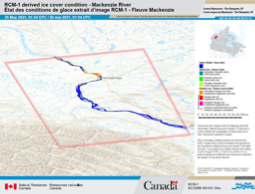
Ice jam monitoring is something that greatly impacts northern communities that lie alongside rivers and can frequently be affected by ice jams that lead to dangerous conditions. Normally, these communities have ice breakup monitoring operations, but during 2020 and 2021, COVID social distancing measures affected these regular operations and resulted in the need for a new approach. The EGS helped communities in the Northwest Territories implement an ice monitoring program that relied upon the use of RADARSAT Constellation Mission (RCM) data. By using SAR to assess the smoothness or relative roughness of ice on the Mackenzie River, EGS and the affected communities were able to remotely assess and monitor the ice jams in a new and innovative way.
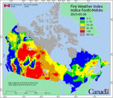
The EGS also supports the Canadian Wildland Fire Information System (CWFIS), which supports near real-time monitoring of active forest fires, and additionally work on fire forecasting efforts. One of the products they publish is the FireM3 Hotspots map which is extracted from data collected by multiple earth observation sources. This can then be enhanced by combination with data from Environment Canada to create informative products like the Fire Weather Index, seen below, that is published daily. The combination of these products contributes to early warning systems for forest fire activity, which last year contributed to the safe evacuation of the town of Jasper and Jasper National Park, an example which we will come back to shortly.
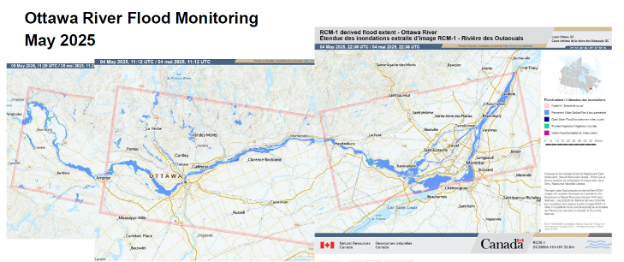
Another important service provided by the EGS is their flood mapping and monitoring program. Using the federally owned RCM, they can derive flood extents and distinguish permanent bodies of water from flooded vegetation, urban flooding, and other flooded areas. This product is available in the form of current floods, floods for year to date, and historical floods. It can be used to make informed, near real-time decisions and the interference independent abilities of SAR again come to the forefront. Below, we can see some flood extents from the Ottawa River in early May 2025.
Seeing through the smoke
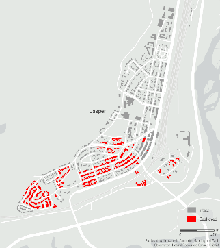
As Canada dives into what is looking to be yet another tragic wildfire season, emerging applications of this technology are being pioneered by the EGS. When the Jasper area was hit hard by wildfires last year, the EGS sprang into action to try and gather and provide intelligence to assess the damage done by the fast-moving blaze. They were able to use RCM radar imagery alongside that acquired from Capella to do preliminary damage assessments.
The advantages of SAR and its wavelength characteristics, combined with RCMs polarimetric capabilities allowed the EGS to create a methodology that distinguished between destroyed and intact structures. These results were then validated using the higher-resolution Capella imagery. But this was all done rapidly and long before the smoke had even cleared. Optical imagery wasn’t available to confirm these results until 8 days later, and it confirmed the EGS’ work to have more than a 90% accuracy rate.
Canada is a global leader in Synthetic Aperture Radar (SAR) technology, having not only pioneered its development but also continuing to advance and set the standard in SAR capabilities through the RADARSAT program. With its unique attributes, such as polarimetry, specialized wavelengths, and all-weather functionality, SAR enables precise, large-scale data collection regardless of environmental conditions. These capabilities make SAR an indispensable tool for geospatial intelligence, particularly in response to increasingly frequent and severe natural disasters.
The outstanding work being carried out within the federal government — especially by the EGS at the Canada Centre for Mapping and Earth Observation — deserves recognition. Thank you to Simon Tolszczuk-Leclerc for showcasing this critical work at GeoIgnite 2025.


Be the first to comment