
When Montréal switched on its Real-Time GNSS Network (RTN), it marked a milestone in Canadian geodesy. By deploying its own standards-compliant GNSS infrastructure, Montréal stands among the pioneering Canadian cities offering centimeter-level positioning accuracy across an entire urban area.
For Youssef Smadi, the senior geodetic engineer at the Geomatics division who led the project, the achievement represents persistence and pride. “I will say it’s a dream that came true,” he reflected. “It’s a vision we pushed forward until it became reality.”
A Long Road to Realization
The first GPS base station in Montréal was installed in 2005. GLONASS capability followed in 2012, but the vision of a complete GNSS network only gained traction in 2016. That was when Smadi was assigned the project and began working to modernize the city’s geodetic infrastructure.
The path required patience and persistence. Budgets had to be secured step by step, and each approval brought the project closer to reality. Strategic partnerships with Natural Resources Canada and partner municipalities were required, and every step had to meet federal CORS standards.
Finding suitable sites for base stations and carrying out the installation proved particularly challenging. “You need stable infrastructure, reliable internet, an unobstructed sky view as well as solid project management,” Smadi explained. “In Montréal, with all the trees, getting full 360-degree clearance was nearly impossible. We achieved about 90 percent.”
The COVID-19 pandemic added further complexity. Installations slowed, approvals took longer, and training had to be adapted. Yet the project pressed on, anchored by the conviction that a robust geodetic backbone would serve the city for decades.
Building a Network That Lasts
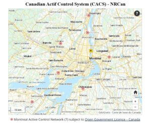
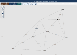
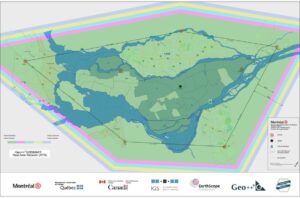
By 2024, Montréal’s RTN included eight stations: seven owned by the city and one from Québec’s Ministry of Natural Resources (MON2). They are distributed across the Montréal region, including Laval, Repentigny, Vaudreuil-Dorion, Châteauguay, and Longueuil, with an average spacing of roughly 25 kilometers. This spacing provides overlapping coverage and ensures redundancy across the metropolitan area.
The city selected last-generation GNSS receivers and choke-ring antennas after consultations with the Canadian Geodetic Survey, which had tested their low noise performance. To ensure stability and future compatibility, each antenna was installed on a SCIGN Mount, designed to keep it level and oriented to true north. This means that when antennas are replaced in the future, coordinate reestimation will be unnecessary, the difference will be within a millimeter.
Smadi emphasized that durability guided every decision: “From the beginning, we wanted a network that could stand for 20 years. That meant respecting every standard, every requirement, so no step had to be redone later.”
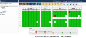
The RTN is powered by GNSMART software (Geo++ GmbH, Germany), which handles real-time modeling of GNSS errors. Implementing this system was itself a milestone: Montréal hosted intensive training with the supplier’s engineer to configure and test the software directly into the city’s infrastructure. The city remains the only one in Canada using GNSMART, a mark of both
ambition and the effort required to bring the system into operation.
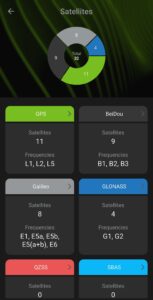
The city also invested in five state-of-the-art mobile receivers, ensuring that its field teams could fully leverage the network’s multi-GNSS, multi-frequency capabilities with RTCM 3 (MSM4) correction messages.
Precision in Practice
The Montréal RTN provides centimeter-level accuracy in real time, with consistent results across the island and surrounding municipalities. For technicians and surveyors, this reliability means turning on a receiver and immediately working with confidence, without needing to think about distance to a base station or manual configuration. The network’s multi-GNSS design gives it the strength and stability required for today’s demanding applications.
“When we tested our network solution on the new mobile receivers, we saw the improvement right away,” Smadi said. “It was a big step in quality.”
Applications Already Underway
The first professionals to adopt the RTN was the city’s drone team. With the new network parameters built into their workflows, drones now lock onto centimeter-precise positions within seconds, reducing the need for ground control points and speeding up operations. Looking ahead, the RTN has potential to support autonomous mobility, emergency services, and smart city applications. Smadi is realistic about the hurdles, particularly GNSS jamming and spoofing for mobility use cases, but believes the foundation is ready.
“For technicians, the network has already changed everything,” he explained. “Before, they had to guess which base station to connect to. Now it’s automatic. They turn on their receiver, and within seconds the system gives them a stable, precise position through the Virtual Reference Station (VRS) solution.”
A City’s Geodetic Milestone
Montréal’s RTN represents a shift in how municipalities see geodesy. For decades, reference networks were the domain of federal or provincial agencies. Montréal has shown that cities can take responsibility for their own geodetic backbone, aligning local operations with national standards while also pushing innovation forward.
The network is integrated with the Canadian Active Control System and Montréal is also a member of EarthScope Consortium and the International GNSS Service (IGS). These memberships make the city part of a global geodetic ecosystem. This collaboration ensures the city’s RTN contributes reliably to both national and international frameworks. It also positions Montreal along with Québec for its eventual transition toward NATRF2022 and
CGVD2013, part of the global modernization of reference frames.
Geodesists often describe their work as the foundation of modern society. As Petr Vaníček once wrote, geodesy is about “measuring the impossible” to provide certainty in an uncertain world. Montréal’s RTN is a concrete expression of that philosophy.
Looking Ahead
Montréal’s RTN reinforces the city’s leadership in precision services, asset management, and geodetic modernization, aligning with its 2030 vision for innovation and smart infrastructure. For surveyors and city crews, the system is already proving its worth. For the wider geospatial community, it serves as a model of how municipal governments can build and own advanced
geodetic infrastructure.
From drones to infrastructure monitoring, from emergency response to future mobility, the influence of this network will continue to grow. The base stations are part of the city’s infrastructure, but their real value is in the confidence they give to every project built on their coordinates.
For Smadi, this project represents years of persistence, coordination, and technical problemsolving. “For me, this milestone is deeply personal. It’s about transforming geodesy from something highly technical into a source of everyday trust and reliability. Watching crews fix within seconds, knowing it’s safe, consistent, and built on the city’s own framework, feels like the culmination of years of effort, challenges, and collaboration. And I want to thank my supervisors, directors, and the city’s IT teams, along with Natural Resources Canada, MERN, our partner cities, and everyone who supported us. It took the effort of many people and organizations to bring this visionary project to life.”


Be the first to comment