
Centimeter-level positioning is no longer a technical breakthrough. RTK, RTN, and wide-area correction services have demonstrated for years that high-precision GNSS is achievable. The real challenge today is not accuracy itself, but access. Delivering centimeter precision reliably, over large geographic areas, and at a cost that supports widespread adoption remains a structural problem.
As robotics, drones, and autonomous systems move from pilot projects to operational deployment, this limitation becomes increasingly visible. Autonomous vehicles navigate complex environments, drones inspect infrastructure beyond visual line of sight, and agricultural machines operate with growing independence, yet all depend on reliable centimeter-level positioning. In practice, precision positioning fails not because correction algorithms are insufficient, but because the underlying infrastructure is sparse, expensive, and slow to expand. In many regions, particularly rural and remote areas, the cost of deploying and maintaining large, fixed reference networks directly limits where and how autonomy can scale.
The Current Landscape of Precision Corrections
Real-Time Kinematic (RTK) positioning remains the gold standard for high-accuracy applications. When a rover operates close to a reference station, RTK delivers fast convergence, low latency, and excellent precision. The challenge has always been proximity: without a nearby base station, performance degrades quickly.
To address this, the industry developed Real-Time Networks and wide-area correction services such as PPP and RTX. These approaches reduce dependence on local infrastructure by relying on broader network coverage, atmospheric modeling, and global reference systems. They work well, particularly where base station density is low or nonexistent, but often involve longer convergence times and greater reliance on fixed infrastructure.
Each of these approaches has merit. The limitation is not technical capability, but economic and structural: how quickly precision can be delivered, how fast it can recover after interruptions, and how effectively it can scale across large or remote areas at reasonable cost.
The Hidden Cost of Sparse Infrastructure 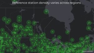
Precision GNSS performance is often discussed in terms of algorithms, correction models, and receiver capabilities. In practice, however, infrastructure density is a dominant factor in both performance and cost. When reference stations are widely spaced, maintaining consistent centimeter-level accuracy requires more complex modeling, longer baselines, and increased dependence on wide-area corrections.
Sparse infrastructure also slows expansion. Deploying new reference stations typically involves significant planning, capital investment, and long lead times, which limits how quickly coverage can respond to emerging demand. In rural and remote regions, this results in persistent gaps where precision positioning is technically possible but economically impractical.
The cost of precision GNSS, therefore, is shaped not only by correction services or equipment, but by how infrastructure is deployed, how easily it can scale, and how efficiently additional coverage can be added where it is needed. Emerging use cases, seasonal operations, and rural regions are often left behind as a result.
A Different Infrastructure Model
An alternative approach is emerging: dense, community-expanded RTK infrastructure built with professional-quality base stations, hosted locally where demand exists. The model is closer to how the internet itself scaled. Early networks relied on a small number of high-capacity nodes connected over long distances. Over time, performance and resilience improved not by making those nodes more complex, but by increasing local density, shortening paths, and distributing infrastructure closer to users.
Instead of a small number of widely spaced reference stations, this approach relies on many stations forming a mesh. When density exists, baselines are short. When one station fails, neighboring stations reduce the impact. Failure domains become smaller, and redundancy emerges naturally from proximity rather than from centralized backup planning.
This is not a new correction algorithm. It is a different way to build and operate physical GNSS infrastructure: incremental, demand-driven, and scalable. Coverage expands where it is needed, when it is needed, without requiring large upfront investments or long planning cycles.
Ensuring Quality at Scale
Expanding RTK infrastructure does not reduce quality if quality is designed into operations. Dense networks require clear standards for hardware, continuous monitoring of data integrity, rapid detection of failures, and accountability for resolution. Without these controls, adding reference stations would increase noise rather than reliability.
Modern distributed RTK networks address this by enforcing standardized, professional-grade equipment, validating station identity, and continuously monitoring uptime, latency, and correction quality. Performance is evaluated in real time, allowing issues such as misconfiguration, signal degradation, or outages to be detected and corrected quickly.
Quality at scale is therefore not a function of ownership, but of operational discipline. When monitoring, validation, and maintenance are consistently applied, distributed infrastructure can deliver professional-grade performance while remaining economically scalable.
From Theory to Practice 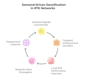

This infrastructure model is not theoretical. In recent years, distributed, community-expanded RTK networks have been deployed at global scale using standardized, professional-grade equipment and continuous performance monitoring. One such network, GEODNET, has grown from a few dozen reference stations to more than 21,000 stations across over 150 countries in less than four years.
Stations are deployed incrementally, where demand exists, and integrated into a unified correction network with consistent performance requirements. The result is a dense and rapidly expanding RTK mesh that complements traditional RTN and wide-area correction services, particularly in regions where infrastructure density was previously limited by cost and deployment speed.
The significance of this example is not tied to a specific organization, but to what it demonstrates: centimeter-level positioning infrastructure can scale globally through a distributed, demand-driven model while maintaining professional operational standards.
Why This Matters for Robotics and BVLOS
For robotics and long-range drone operations, dense RTK infrastructure changes what is operationally possible. Shorter baselines improve robustness, re-convergence after outages is faster, and reliance on ground control points is reduced. Failure domains are smaller and easier to manage.
Just as important, the economics shift. Precision positioning becomes viable for smaller operators, pilot projects, and seasonal or mobile use cases. Infrastructure can be deployed where robots operate today, not only where coverage planners predicted demand years ago.
Connectivity Is No Longer the Limiting Factor
Historically, RTK over the internet struggled in rural areas due to connectivity gaps. This constraint is rapidly diminishing. Low-Earth-orbit satellite internet is delivering low-latency connectivity far beyond traditional networks in many regions.
As connectivity improves, the value of distributed RTK infrastructure increases. Precision corrections are no longer strictly constrained by geography, and many historical dead zones are becoming operationally viable.
Complementary, Not Competitive
It is important to be precise. Dense RTK networks do not eliminate the need for RTN or wide-area correction services. In regions with low station density, RTN and RTX remain excellent solutions.
It is also important to recognize where distributed RTK may be less appropriate. Applications requiring formal survey control, integration into national geodetic frameworks, or compliance with specific regulatory standards may continue to rely on established RTN or dedicated control networks. In these contexts, traceability, certification, and governance requirements can outweigh the economic advantages of incremental infrastructure expansion.
The advantage of community-expanded RTK is primarily economic and operational. Where density exists or can be added easily, it can deliver comparable performance at lower cost in many operational scenarios. Expansion is incremental, resilient, and demand-driven. The future of precision positioning is hybrid, with different tools for different conditions and use cases.
Infrastructure Determines the Pace of Autonomy
Autonomous systems are ready. Sensors are capable. Algorithms are mature.
What limits adoption today is infrastructure: how fast it can be deployed, how resilient it is, and how affordable it becomes when scaled across large territories. For countries with vast geography, dispersed populations, and significant rural and remote activity, these constraints are not theoretical. They directly shape which technologies reach operational scale and which remain confined to pilots.
Canada’s size, seasonal operations, and diversity of industries place unique demands on positioning infrastructure. Models that rely on incremental expansion, local density, and rapid deployment are therefore not just technically viable, but strategically aligned with the realities of operating across the country. Community-expanded RTK networks represent a shift from fixed planning cycles to adaptive growth, enabling precision positioning to scale where and when it is needed.
For Canada, this approach is not simply an alternative. It is an opportunity to align infrastructure with geography, economics, and the pace of autonomy itself.


Be the first to comment