
From Arctic geometry gaps to sovereignty exposure, can Canada afford continued dependence on external GNSS systems?
The strategic silence in Ottawa has finally broken. For decades, Canada’s reliance on the American Global Positioning System (GPS) was treated as a fundamental constant of our national infrastructure.
But as reported last week in The Logic, a striking shift in Canadian strategic thinking is underway. Canada’s space and military leaders are now openly discussing a sovereign alternative to GPS. Not because the technology is failing, but because the global security landscape has fundamentally shifted.
The timing is notable. Canada is simultaneously re-examining critical infrastructure resilience and strategic sovereignty across multiple sectors.
While the call for a sovereign GPS alternative was voiced loudly by MDA Space CEO Mike Greenley, the echo coming from the Department of National Defence is even louder. With Brig.-Gen. Chris Horner of the 3 Canadian Space Division now warning that GPS dependency is a “$1 billion-a-day” gamble, the line between commercial advocacy and military necessity has officially blurred.
The ‘Third Country’ Trap: Lessons from the Brexit Fallout
I argued this point last year: Canada remains strategically dependent on external GNSS systems despite being the second-largest country in the world. In the shifting geopolitical landscape of 2026, we find ourselves caught in the realities of the “Third-Country” status.
The United Kingdom learned this lesson unceremoniously during the Brexit negotiations. Despite being a primary architect and funder of the EU’s Galileo project, Britain was unceremoniously locked out of the Public Regulated Service (PRS) — the encrypted, military-grade signal — the moment it became a “third country.”
Canada faces an even steeper climb. Despite being a member of the European Space Agency (ESA), we are the only non-European state. This status allows us to bid on contracts, but it does not grant us access to the sovereign heart of Galileo: the PRS. We are essentially left with the “Open Service” — a signal that is subject to the same vulnerabilities as civilian GPS.
The Sovereign PNT Club: Breaking the Dependency
Other nations have already recognized that Position, Navigation, and Timing (PNT) is no longer a neutral utility but can be a weaponizable asset. The global shift toward sovereign systems is driven by a single realization: in a crisis, “denial of service” is a strategic weapon.
- India’s NavIC: This system was born from the strategic sting of the 1999 Kargil War with Pakistan. When the U.S. denied India critical GPS data during the conflict, New Delhi realized that relying on a foreign-controlled signal was a fundamental threat to national survival. NavIC was built specifically to ensure that India would never again be “blinded” by a partner’s policy shift.
- Japan’s QZSS: Rather than just replicating GPS, Japan built a “regional” constellation that “dwells” directly over Japanese territory. By controlling their own signals, they ensure high-precision coverage that remains resilient even if global systems are compromised or jammed.
- Australia’s SouthPAN and the SHIELD Initiative: Australia and New Zealand launched the Southern Positioning Augmentation Network (SouthPAN) in 2022, investing over $1 billion to ensure decimeter-level accuracy across the continent. By early 2026, Australia has moved beyond simple accuracy to legal resilience. Through the SHIELD (Secure, Hardened, Integrity-Enhanced, Location and Timing Defence) initiative, Australia is developing the sovereign technology required to meet new mandates under the Security of Critical Infrastructure (SOCI) Act. This legislation treats PNT as a national utility, requiring power grids and defense forces to develop GPS-independent backups to ensure they never run on a “borrowed clock”.
- Norway’s “Satellite-Free” Timing: Norway is actively building a national fiber-based timing network to protect its infrastructure from constant GPS jamming in its far north. By distributing high-precision time via fiber optics from local atomic clocks, Norway is achieving “satellite-independent” sovereignty for an investment of just NOK 85 million (approximately $11 million CAD).
Canada remains one of the few major economies still operating as a “hitchhiker,” effectively granting another power a “kill switch” over our national infrastructure.
The Arctic Vacuum: Where Geography Meets Geopolitics
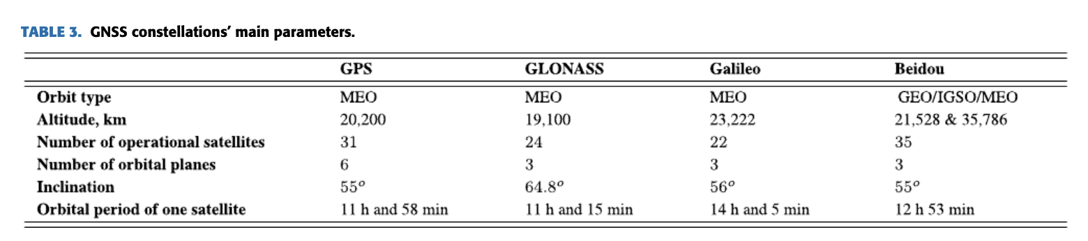
The problem for Canada isn’t just political; it’s a matter of basic orbital mechanics. GPS (and even Europe’s Galileo) was never optimized for the High North. Most navigation satellites primarily circle the Earth at an inclination of roughly 55 to 56 degrees, effectively staying over the Earth’s “mid-section.”
As a user moves north of Edmonton (53.5°N), this geometry begins to degrade. This creates two immediate, measurable problems:
- The “Geometry Gap” (VDOP): Because no GPS satellites pass directly overhead, they “cluster” low on the southern horizon in the Arctic. This creates a permanent “hole” at the zenith. This poor geometry makes vertical accuracy — essential for landing aircraft or navigating narrow channels — unreliable. Accuracy that is measured in centimeters in Toronto can degrade by three times or more in the High North.
- The “Slant Path” Distortion: In the Arctic, signals must travel a longer “slant path” through the atmosphere. This path crosses the most turbulent part of the ionosphere — the same area that creates the Aurora Borealis. This causes scintillation (signal twinkling) which, during solar storms, can cause receivers to lose their lock entirely, leading to errors of tens or even hundreds of meters.
The ‘Digital High Ground’ of the North
The irony of our Arctic sovereignty is that Russia holds the technical edge there. Their GLONASS satellites were built with a much steeper orbit (inclination 64.8 degrees), specifically designed to stay “overhead” in the polar regions where GPS fails.
This creates a dangerous ‘PNT vacuum’ across the Canadian Arctic Archipelago — a vast maritime labyrinth where traditional satellite geometry is at its most fragile. As climate change thins the ice and opens the Northwest Passage to global shipping, Canada’s ability to monitor and regulate its own waters is tethered to a foreign signal that is fundamentally at its weakest exactly where our sovereignty is most contested.
We are attempting to defend the world’s longest coastline with a map that gets blurrier the further north we go!
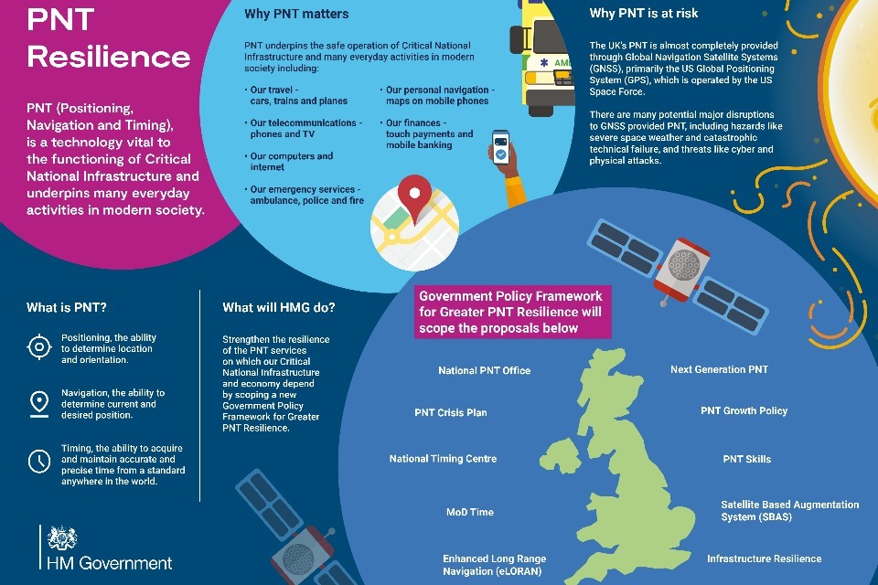
The UK’s £155M Resilience Blueprint: Resilience Over Replication
The immediate pushback against a sovereign GNSS is always the cost. Building a satellite constellation like GPS takes decades and tens of billions of dollars. After Galileo lockout, Britain initially toyed with the idea of building its own GNSS system.
However, in November 2025, the UK abandoned the “satellite-only” pursuit and launched a massive £155M investment to safeguard their PNT infrastructure. This landmark move focuses on four distinct “Sovereign Layers”:
- The £71M eLoran Rollout: A national program to provide ground-based PNT that is completely independent of satellites and virtually unjammable — the “sovereign floor” for land, air, and sea.
- National Timing Centre (£68M): Developing the UK’s first nationally distributed time infrastructure to protect 5G, stock markets, and power grids from GPS outages.
- Threat Monitoring (£13M): A world-leading system to proactively detect and react to GPS jamming and spoofing in real-time.
- Space-Based Time Transfer (£3M): Developing “satellite-independent” global timing technology to ensure resilience even if GNSS networks fail entirely.
Beyond this infrastructure, the UK is already trialing the “tactical layer” of this architecture. In October 2025, the Royal Navy successfully tested “toaster-sized” quantum sensors aboard the uncrewed submarine XV Excalibur. These devices use ultra-cold atoms to measure movement so precisely that they can navigate for extended periods without external radio signals.
The Case for Canada: Building the Resilience Layer
The current debate risks collapsing into an unproductive binary: either Canada builds a full sovereign GNSS constellation, or it remains dependent. Even a regional system focused on the Arctic — similar to India’s NavIC or Japan’s QZSS — would require substantial capital, years of development, and political continuity that must survive multiple election cycles.
Canada’s core vulnerability is not the absence of a domestic GNSS. It’s the absence of a layered PNT architecture designed to eliminate single-point dependency. The immediate opportunity is to build what can be called a resilience layer.
Through its IDEaS (Innovation for Defence Excellence and Security) program, the Department of National Defence has issued a challenge for Resilient Non-GPS Positioning, Navigation and Timing. The objective is to develop systems that function when satellite signals are degraded, denied, or unavailable. Current projects include:
- Navigation in GPS-Denied Environments Using Hybrid Adaptive SLAM
- Quantum-Enhanced Navigational Sensors
- Field-Deployable Quantum-Enhanced Fiber Optical Gyroscopes
- Geolocation in GPS-Denied Environments Using Deep Learning-Based Multi-Temporal Cross-View Data Fusion
In parallel, a separate IDEaS initiative, Time Without Limits, is advancing tactical-grade timing systems capable of maintaining precise time in GPS-denied northern environments.
These defence-driven investments point to a broader reality: Canada already has many of the building blocks of sovereign PNT.
- eLoran as the Sovereign Floor: Canada decommissioned its terrestrial Loran network in 2010, removing a hardened backup layer and deepening reliance on foreign satellite systems. A modern eLoran network, modeled on the UK rollout, would provide a high-power, jam-resistant ground-wave signal. Because these signals follow the curvature of the Earth, they remain effective in high-latitude regions where satellite geometry weakens.
- Low Earth Orbit (LEO) Augmentation: Rather than replicating a deep-space GNSS constellation 20,000 kilometres above Earth, Canada could prioritize LEO systems. Their proximity enables stronger signals, improved anti-jamming resilience, and better high-latitude precision. Canadian-linked initiatives, including Xona Space Systems and MDA’s 49North division, demonstrate that capability is emerging domestically.
- Securing the Geodetic Anchor: Any sovereign PNT architecture is only as reliable as the reference frame that anchors it. Currently, Canada’s geodetic infrastructure is in a critical state, creating a “void” that undermines our economic and defense sectors. Without a significant funding injection to upgrade this foundational layer, any new “made-in-Canada” signals will still be forced to calibrate against foreign frameworks.
No More Hitchhiking
In 2025, the UK established a National PNT Office to act as the “strategic glue” for their multi-layered “System of Systems.” Canada has the ingredients — a world-class geomatics industry, a robust geodetic foundation, and commercial ambition. What we lack is the recipe — a cohesive, coordinated National PNT Strategy.
Without a central body to coordinate these efforts across civilian and military sectors, we risk building a collection of impressive technologies that don’t actually form a cohesive, resilient whole.
The $1 billion-a-day risk identified by our military is a wake-up call that PNT is no longer a “free” utility, but a national security gap. From the autonomous tractors of the Prairies to the search-and-rescue pilots in the North, our economy is running on a borrowed clock.
Canada’s era as a “hitchhiker” must end.
We don’t need to build a new GPS; we need to build a resilient, sovereign foundation that ensures Canada always has a path forward, regardless of how the global map shifts.


Be the first to comment