
Where Do I Even Park?
If you’ve ever driven through Uptown Waterloo, Ontario or near the University of Waterloo campus, you know the struggle — circling for parking, reading confusing signs, or landing in lots with permit-only restrictions. It’s a common urban frustration that got me thinking: How can geospatial tools help simplify parking in Waterloo, Ontario?
This led to the creation of an interactive, map-based parking finder app — a simple solution built using Python, Streamlit, and open geospatial data to make parking in Waterloo more accessible and informed.
A Glimpse at the App
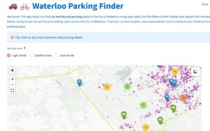
Users can:
- Multiple map views available: Dark, Light & Satellite
- Search areas within Waterloo to see available parking
- Zoom into hotspots
- Measure the distance to the parking lot.
- Click on features to reveal details about parking types and rules
- Navigate easily through a responsive and intuitive interface
- Try the App: Parking Finder
Geospatial Data in Action
The parking data was sourced from OpenStreetMap and municipal Region of Waterloo open data, then refined and exported in GeoJSON format for mapping. Each feature includes attributes such as:
- Type (public lot, private)
- Fee
- Accessibility features
These spatial layers are rendered on an interactive map, allowing users to explore, zoom, and click for more information.
The Tech Behind the Tool
This parking finder app is powered by:
- Streamlit: For creating an interactive, user-friendly web interface
- OpenStreetMap: As a detailed, open-source basemap and open street map data.
- GeoJSON: To visualize parking locations for bicycles in the city.
- Folium + streamlit folium: To integrate interactive Leaflet maps directly into Streamlit
The result is a lightweight and intuitive app that helps users locate nearby parking lots and spaces based on their current location or area of interest.
Why It Matters
This isn’t just about convenience. This project highlights how:
- Open data can support local solutions
- Python and geospatial libraries can translate complex problems into usable tools
- Civic tech can make small but meaningful improvements in daily life
In a growing city like Waterloo, urban mobility challenges are only increasing. This app is an example of how geospatial thinking — combined with developer initiative — can bridge information gaps in public infrastructure.
As a GIS and Python enthusiast, I am excited about how open data and geospatial technology can continue to improve urban experiences. If you’re a fellow developer, data enthusiast, or civic planner, let’s connect and collaborate on more local mapping solutions.

Be the first to comment