• facebook
  • Twitter
  • Linkedin
  • Youtube
  • Linkedin Group
  • Post a Job
  • Post an Ad
  • Post an Event
  • Post a Directory Listing
  • Post a Press Release
  • Media Kit
  • My Account
  • Login
GoGeomatics
  • MAGAZINE
    • BIM & GIS
    • Community
    • Conference news
    • Earth Observation
    • Education & Careers
    • GEOAI
    • Announcements
    • Reality Capture & Lidar
    • Science
    • Technology
  • Directories
    • ASSOCIATION
    • INDUSTRY
    • EDUCATION
    • Open Data
  • EVENTS
    • GeoIgnite Events
    • Events Calendar
    • GoGeomatics Meetups
  • Services
    • Advertising
    • Marketing
    • Post a Job
    • Post an Ad
    • Post an Event
    • Post a Press Release
    • Post a Directory Listing
    • Media Kit
    • Web Design
  • Find a Job
  • Volunteer
    • Start a GoGeomatics Group
    • Editors & Writers Group
  • About Us
    • About Us
    • Contact Us
    • Frequently Asked Questions
  • Videos
Homechange

change

|||||||||
Technology

QGIS & WorldClim: Using Zonal Statistics to Map Temperature Patterns

31 October 2016 GIS Program Langara CS | Alaska

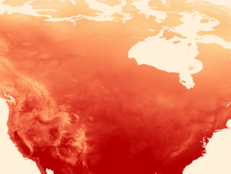
There has never been a time in the history of GIS when so much free, high quality data has been available. As an example, the WorldClim site (http://www.worldclim.org/) offers temperature raster data, on a global […]

No Picture
Newsmakers & Press Releases

NB 911 Bureau Receives Esri Canada Award of Excellence in GIS

26 October 2016 GoGeomatics Newsmakers | 2012

FREDERICTON, Esri Canada User Conference – October 25, 2016 – Esri Canada today presented the NB 911 Bureau, a branch of the New Brunswick Department of Justice and Public Safety, with an Award of Excellence […]

|
Newsmakers & Press Releases

DigitalGlobe’s Basemap Suite Expands: 250 Million Square Kilometers of 30 cm Imagery

4 October 2016 GoGeomatics Newsmakers | accuracy

DigitalGlobe, Inc. (NYSE: DGI), the global leader in Earth imagery and information about our changing planet, today announced that its online Basemap Suite has reached a significant milestone, with the availability of more than 250 […]

||
Education & Careers

UAVs in Canada – Key Exposures to Loss and Ways to Protect Yourself

3 October 2016 Association of Ontario Land Surveyors | 2014

This article was written by Mark Sampson for the Association of Ontario Land Surveyors. Mark’s contact details are at the bottom of the article and here is a direct link. Drones are referred to interchangeably […]

||
Newsmakers & Press Releases

Earth Observation Represents a $43 Billion Opportunity Over Next 10 Years

8 September 2016 GoGeomatics Newsmakers | analysis

NSR’s Satellite-Based Earth Observation (EO), 8th Edition report, released yesterday, projects data, value-added services, information products, and big data analytics from satellite-based earth Observation (EO) to represent a $43 billion opportunity over the next decade. […]

|
Technology

LiDAR in Canada: Conversation with Dr. Chris Hopkinson Research Chair Remote Sensing University of Lethbridge

6 September 2016 Robert Maher | 3D

The author Bob Maher (BM) and Chris Hopkinson (CH) both worked as scientists at the Appied Geomatics Reearch Group (AGRG) between 2004-2011. Five years later, it was time to catch up. Chris is currently Research […]

Newsmakers & Press Releases

CIG Advancements in Geomatics 2016 Conference in New Brunswick Sept 26th-28th

31 August 2016 GoGeomatics Newsmakers | 2016

Advancements in Geomatics – Research and Collaboration for Informed Decisions in a Changing World The Canadian Institute of Geomatics (CIG) New Brunswick Branch and the Conference Organizing Committees, invite you to join us as a […]

No Picture
Newsmakers & Press Releases

International Spatial Symposium in Quebec City: CAMUSS 2016

29 August 2016 GoGeomatics Newsmakers | 2016

You are cordially invited to participate in the Second International Symposium on Cellular Automata Modeling for Urban and Spatial Systems (CAMUSS 2016) that will be held in a beautiful UNESCO World Heritage Site, Quebec City, […]

Posts pagination

« 1 … 5 6 7 … 38 »

Events

Notice
There are no upcoming events.

View All Events

Services

  • Post a Job
  • Post an Ad
  • Post an Event
  • Post a Directory Listing
  • Post a Press Release
  • Media Kit
  • My Account
  • Login

Jobs

Post a Job
  • Canada Maps and Poster Gallery Volunteer Leads — GeoIgnite 2026
    remote
  • GIS & Data Analytics Lead
    Beaumont, AB
  • Lead Surveyor, Projects/Arpenteur-géomètre principal, projets; arpenteuse-géomètre principale, projets
    North Bay, Thunder Bay
  • Senior GIS Developer
    Calgary, AB
View All Jobs
  • Directories
    • Associations Directory
    • Industry Directory
    • Education Programs
    • Open Data
  • Volunteer
    • Start a GoGeomatics Group
    • Editors & Writers Group
  • About Us
    • GoGeomatics Media Kit
    • Who We Are
    • Contact Us
    • FAQ’s
    • Advertising
    • Marketing
  • Subscribe
GoGeomatics
GoGeomatics is the largest and most popular communications hub promoting the Canadian geospatial community. The business was incorporated in 2011. GoGeomatics hosts over 100 fun, free, location technology networking events each year in cities across Canada.

© 2025 GoGeomatics

  • facebook
  • Twitter
  • Linkedin
  • Youtube
  • Linkedin Group