• facebook
  • Twitter
  • Linkedin
  • Youtube
  • Linkedin Group
  • Post a Job
  • Post an Ad
  • Post an Event
  • Post a Directory Listing
  • Post a Press Release
  • Media Kit
  • My Account
  • Login
GoGeomatics
  • MAGAZINE
    • BIM & GIS
    • Community
    • Conference news
    • Earth Observation
    • Education & Careers
    • GEOAI
    • Announcements
    • Reality Capture & Lidar
    • Science
    • Technology
  • Directories
    • ASSOCIATION
    • INDUSTRY
    • EDUCATION
    • Open Data
  • EVENTS
    • GeoIgnite Events
    • Events Calendar
    • GoGeomatics Meetups
  • Services
    • Advertising
    • Marketing
    • Post a Job
    • Post an Ad
    • Post an Event
    • Post a Press Release
    • Post a Directory Listing
    • Media Kit
    • Web Design
  • Find a Job
  • Volunteer
    • Start a GoGeomatics Group
    • Editors & Writers Group
  • About Us
    • About Us
    • Contact Us
    • Frequently Asked Questions
  • Videos
Homeclimate resilience

climate resilience

Earth Observation

Canadian Geospatial Digest – January 12, 2026

12 January 2026 Volunteer Editors and Group Writers | 3D Digital twin

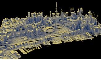
PhotoSat Launches Regional Hyperspectral Targeting Tool for Mineral Exploration NordSpace’s Atlantic Spaceport Clears Environmental Review, Moves Toward Canada’s First Orbital Launch Site 3D Mapping Pilot Shows How Indoor GIS Could Improve Safety in Edmonton’s LRT […]

Earth Observation

National Elevation Data Strategy: A Decade of Innovation and Progress

27 November 2025 David Belanger | Building Footprints Automatically Extracted Buildings ArcticDEM

In 2015, Natural Resources Canada (NRCan) launched the National Elevation Data Strategy (NEDS), a bold initiative to modernize Canada’s landmass data foundation. Ten years later, the NEDS has become a cornerstone of Canada’s geospatial ecosystem, delivering […]

C-Suite
BIM & GIS

Inside the C-Suite Conversation Shaping Canada’s Digital and Geospatial Future

13 November 2025 Anusuya Datta | BigGeo

As Canada’s geomatics and Earth Observation leaders gathered in Calgary for the C-Suite Panel at GoGeomatics Expo 2025, the timing couldn’t have been more fitting. The session had been planned around a clear signal from […]

Conference news

Be Part of GeoIgnite 2026: Call for Sponsors and Speakers Now Open!

12 November 2025 GoGeomatics Canada | and sustainable development.

GeoIgnite 2026 will take place from May 11–13, 2026, at the Ottawa Conference and Event Centre, and we’re inviting sponsors and speakers to take the spotlight at Canada’s National Geospatial Leadership Conference. This is an […]

BIM & GIS

3D Mapping Transforms Smoke Monitoring

22 October 2025 Alefiya Dungrawala | 2D mapping

Wildfires across North America are no longer confined to a single season. Each year, they burn longer, spread faster, and shatter new records. Satellites have helped scientists track their movement and map the destruction in […]

Community

NRCan’s e-Bulletin Highlights WildFireSat Progress

17 October 2025 David Legris | Arctic Development Expo

Natural Resources Canada has unveiled the WildFireSat e-Bulletin, a new periodic update that highlights developments in Canada’s satellite mission dedicated to monitoring wildland fires. WildFireSat is poised to become the world’s first purpose-built operational satellite […]

Canada Geospatial Strategy
BIM & GIS

Canada Has an AI Strategy. Why Not a Geospatial One?

8 October 2025 Anusuya Datta | Arctic

Canada has shown it can move fast when it decides something matters. Artificial intelligence is the proof. The Pan-Canadian AI Strategy, launched in 2017, was the world’s first funded national AI strategy. It built a […]

NISAR Earth Satellite
Earth Observation

NISAR Releases First Radar Images: A New Phase Begins for the NASA–ISRO Mission

6 October 2025 Sree Vishnu Priya Donepudi | Agriculture Monitoring

A Follow-Up to July’s Anticipation As previously reported in GoGeomatics’ July 2025 International Geospatial Digest, the NASA–ISRO Synthetic Aperture Radar (NISAR) mission was launched with great anticipation as one of the most powerful Earth-observing radar […]

Posts pagination

1 2 … 6 »

Events

Notice
There are no upcoming events.

View All Events

Services

  • Post a Job
  • Post an Ad
  • Post an Event
  • Post a Directory Listing
  • Post a Press Release
  • Media Kit
  • My Account
  • Login

Jobs

Post a Job
  • Systems Analyst – Asset Management and GIS
    Yellowknife, Northwest Territories
  • Canada Maps and Poster Gallery Volunteer Leads — GeoIgnite 2026
    remote
  • Volunteer Editorial Contributor – Be Part of Canada’s Geomatics Story
    Remote
  • BIM Digital Strategy Consultant
    Toronto, ON
View All Jobs
  • Directories
    • Associations Directory
    • Industry Directory
    • Education Programs
    • Open Data
  • Volunteer
    • Start a GoGeomatics Group
    • Editors & Writers Group
  • About Us
    • GoGeomatics Media Kit
    • Who We Are
    • Contact Us
    • FAQ’s
    • Advertising
    • Marketing
  • Subscribe
GoGeomatics
GoGeomatics is the largest and most popular communications hub promoting the Canadian geospatial community. The business was incorporated in 2011. GoGeomatics hosts over 100 fun, free, location technology networking events each year in cities across Canada.

© 2026 GoGeomatics

  • facebook
  • Twitter
  • Linkedin
  • Youtube
  • Linkedin Group