Technology
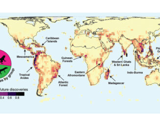
International Geospatial Briefing April 19th: Wyoming Mapping Project Helps Identify Important Habitats; Map of the Mafia Gives Deeper Insights into Former Operations; Animated Map Shows History of Earthquakes and Tsunamis Around the World; OGC API Allows Vector Data Transmission in Any Coordinate Reference System; Interactive Map Could Help Scientists Discover Previously Unknown Species
New Wyoming Mapping Project Helps Identify Important Habitats for Protection A new mapping project by the Wyoming Game and Fish department identifies all of the priority habitats in the state. Using GIS to identify and […]