• facebook
  • Twitter
  • Linkedin
  • Youtube
  • Linkedin Group
  • Post a Job
  • Post an Ad
  • Post an Event
  • Post a Directory Listing
  • Post a Press Release
  • Media Kit
  • My Account
  • Login
GoGeomatics
  • MAGAZINE
    • BIM & GIS
    • Community
    • Conference news
    • Earth Observation
    • Education & Careers
    • GEOAI
    • Announcements
    • Reality Capture & Lidar
    • Science
    • Technology
    • Between the Poles
  • Directories
    • ASSOCIATION
    • INDUSTRY
    • EDUCATION
    • Open Data
  • EVENTS
    • GeoIgnite Events
    • Events Calendar
    • GoGeomatics Meetups
  • Services
    • Advertising
    • Marketing
    • Post a Job
    • Post an Ad
    • Post an Event
    • Post a Press Release
    • Post a Directory Listing
    • Media Kit
    • Web Design
  • Find a Job
  • Volunteer
    • Start a GoGeomatics Group
    • Editors & Writers Group
  • About Us
    • About Us
    • Contact Us
    • Frequently Asked Questions
  • Videos
Homedevelopment

development

||
Community

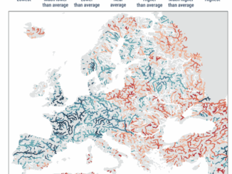
European State of the Climate: Extreme Events in Warmest Year on Record

21 April 2025 Charles Duncan | climate

A recent report on the European State of the Climate issued by the Copernicus Climate Change Service and the World Meteorological Organization highlights that Europe experienced its warmest year on record in 2024, which was […]

Canadian-digest-April-14|
Earth Observation

Canadian Geospatial Digest – April 14, 2025

14 April 2025 Volunteer Editors and Group Writers | Canada

Wildlife Without Borders: Cross-Border Conservation Under Threat Drones for Disaster: UVic’s Smart Mapping Tool Takes Flight Canada’s Weather Map Flips: Arctic Warmer Than Southern Ontario Restoring the Past: Tremaine Map of Upper Canada Now on […]

Community

Exploring the Future of Hydrospatial Technologies at GeoIgnite 2025

14 April 2025 GoGeomatics Canada | Autonomous Survey Vessels

Hydrospatial technologies are increasingly becoming critical in addressing some of the most pressing environmental and safety challenges. From managing flood risks and monitoring coastal areas to improving maritime navigation and supporting climate resilience, hydrospatial data […]

|PacGeo|Maxar satellite|Maxar satellite|
Earth Observation

Pacific Geomatics Brings Maxar’s WorldView Legion to Canadian Projects

11 April 2025 GoGeomatics Canada | constellation

Pacific Geomatics (PacGeo), a leading Canadian satellite imagery provider, is pleased to announce a limited-time special tasking promotion for Canadian organizations to access high-resolution satellite imagery at an outstanding value. Maxar Intelligence, a longstanding partner […]

International-Digest-April-7||||||
Community

International Geospatial Digest for April 7, 2025

7 April 2025 Volunteer Editors and Group Writers | Arctic

Greenland Map Showing ‘Strategic Resources’ Eyed by USA, China Mapping the Destruction from the Myanmar Earthquake Apple Maps Adds More Than 250 Indigenous Placenames in Australia Stormy Rains in the Sahara Offer Clues to Past […]

Canada atlas
BIM & GIS

Canada Must Leverage Its Geospatial Legacy to Embrace New Opportunities

7 April 2025 Jon Murphy | business

How times have changed. Canada’s critical geospatial ecosystem is at a pivotal moment. For decades, our close ties with the United States have offered important strategic advantages—access to cutting-edge technologies, expansive markets, and valuable partnerships. […]

|
Earth Observation

Seeing What Lies Beneath: Seafloor Mapping in a Marine Protected Area

7 April 2025 Benedicta Antwi Boasiako | bathymetry

When people think of conservation, they often imagine forests, wildlife reserves, or coral reefs. But what about the deep, quiet stretches of ocean that we know almost nothing about? That’s exactly what makes Ascension Island […]

Conference news

GeoIgnite 2025 Keynotes: Shaping Canada’s Geospatial Future

3 April 2025 GoGeomatics Canada | buildingSMART Canada

GeoIgnite 2025 is fast approaching and it’s shaping up to be an essential event for those in the Canadian geospatial industry. This year’s keynotes will feature a series of high-level discussions that dive deep into […]

Posts pagination

« 1 … 11 12 13 … 56 »

Events

Notice
There are no upcoming events.

View All Events

Services

  • Post a Job
  • Post an Ad
  • Post an Event
  • Post a Directory Listing
  • Post a Press Release
  • Media Kit
  • My Account
  • Login

Jobs

Post a Job
  • Operations Spatial Data Assistant (Contract)
    Vaughan
  • GIS Analyst
    Saint John, New Brunswick
  • GIS Student Intern
    Elmsdale, Nova Scotia
  • Canada Impact+ Research Chair – Professor (Or Associate Professor)
    Lethbridge, Alberta
View All Jobs
  • Directories
    • Associations Directory
    • Industry Directory
    • Education Programs
    • Open Data
  • Volunteer
    • Start a GoGeomatics Group
    • Editors & Writers Group
  • About Us
    • GoGeomatics Media Kit
    • Who We Are
    • Contact Us
    • FAQ’s
    • Advertising
    • Marketing
  • Subscribe
GoGeomatics
GoGeomatics is the largest and most popular communications hub promoting the Canadian geospatial community. The business was incorporated in 2011. GoGeomatics hosts over 100 fun, free, location technology networking events each year in cities across Canada.

© 2026 GoGeomatics

  • facebook
  • Twitter
  • Linkedin
  • Youtube
  • Linkedin Group