• facebook
  • Twitter
  • Linkedin
  • Youtube
  • Linkedin Group
  • Post a Job
  • Post an Ad
  • Post an Event
  • Post a Directory Listing
  • Post a Press Release
  • Media Kit
  • My Account
  • Login
GoGeomatics
  • MAGAZINE
    • BIM & GIS
    • Community
    • Conference news
    • Earth Observation
    • Education & Careers
    • GEOAI
    • Announcements
    • Reality Capture & Lidar
    • Science
    • Technology
  • Directories
    • ASSOCIATION
    • INDUSTRY
    • EDUCATION
    • Open Data
  • EVENTS
    • GeoIgnite Events
    • Events Calendar
    • GoGeomatics Meetups
  • Services
    • Advertising
    • Marketing
    • Post a Job
    • Post an Ad
    • Post an Event
    • Post a Press Release
    • Post a Directory Listing
    • Media Kit
    • Web Design
  • Find a Job
  • Volunteer
    • Start a GoGeomatics Group
    • Editors & Writers Group
  • About Us
    • About Us
    • Contact Us
    • Frequently Asked Questions
  • Videos
HomeFast

Fast

Community

The 5 most interesting things that happened in geomatics in 2016

21 December 2016 Florin-Daniel Cioloboc | 2016

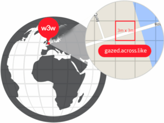
Let’s take a step back and have a look at what happened this year. To be honest, it was pretty hard selection. There are way too many things happening at this point around the world. […]

|||
Technology

Predicting the Future of the GIS in Canada

1 December 2016 Gordon Plunkett | 2015

Editors note: This article has been jointly written by Bruce McCormack and Gordon Plunkett. Bios can be found at the bottom of the article. Most people like to predict the future. People are interested in […]

|||
Community

Contrasting: GIS & Geomatics Education in Canada and China

30 November 2016 Francis Guo | analysis

I have studied Geographic Information Systems (GIS) in both Canada and China. Last summer I completed my master in geography at University of Waterloo. In this article I will draw upon my experiences in China and […]

Newsmakers & Press Releases

what3words adopted by six national mapping agencies

25 November 2016 GoGeomatics Newsmakers | 2013

what3words, the multi-award winning location reference system, has today announced that six national mapping agencies have adopted 3-word addresses. Used to input and share locations within national online geoportals, what3words is making it simpler for […]

Newsmakers & Press Releases

New Brunswick: CARIS Announces release of HIPS and SIPS™ 10

1 November 2016 GoGeomatics Newsmakers | 2016

Fredericton, NB, Canada – November 01, 2016 – Teledyne CARIS™ is pleased to announce the release of HIPS and SIPS™ 10. This release introduces exciting new capabilities for automation, efficiency, and usability through the integration of […]

|
Newsmakers & Press Releases

URISA Heads to Toronto for GIS-Pro 2016

9 September 2016 GoGeomatics Newsmakers | 2016

The Urban and Regional Information Systems Association (URISA), in partnership with its Ontario, Alberta and British Columbia Chapters, is pleased to share the details of GIS-Pro 2016: URISA’s 54th Annual Conference. The event will take […]

|
Technology

LiDAR in Canada: Conversation with Dr. Chris Hopkinson Research Chair Remote Sensing University of Lethbridge

6 September 2016 Robert Maher | 3D

The author Bob Maher (BM) and Chris Hopkinson (CH) both worked as scientists at the Appied Geomatics Reearch Group (AGRG) between 2004-2011. Five years later, it was time to catch up. Chris is currently Research […]

No Picture
Newsmakers & Press Releases

Airobotics Selects SimActive’s Photogrammetry Software for its Automated Industrial Drone Solution

30 August 2016 GoGeomatics Newsmakers | 2016

Montreal, Canada, August 30th, 2016 – SimActive Inc., a world-leading developer of photogrammetry software, is pleased to announce that Airobotics has chosen Correlator3D™ for its drone platforms. The software will be used to derive mapping […]

Posts pagination

« 1 2 3 … 12 »

Events

Notice
There are no upcoming events.

View All Events

Services

  • Post a Job
  • Post an Ad
  • Post an Event
  • Post a Directory Listing
  • Post a Press Release
  • Media Kit
  • My Account
  • Login

Jobs

Post a Job
  • Canada Maps and Poster Gallery Volunteer Leads — GeoIgnite 2026
    remote
  • GIS & Data Analytics Lead
    Beaumont, AB
  • Lead Surveyor, Projects/Arpenteur-géomètre principal, projets; arpenteuse-géomètre principale, projets
    North Bay, Thunder Bay
  • Senior GIS Developer
    Calgary, AB
View All Jobs
  • Directories
    • Associations Directory
    • Industry Directory
    • Education Programs
    • Open Data
  • Volunteer
    • Start a GoGeomatics Group
    • Editors & Writers Group
  • About Us
    • GoGeomatics Media Kit
    • Who We Are
    • Contact Us
    • FAQ’s
    • Advertising
    • Marketing
  • Subscribe
GoGeomatics
GoGeomatics is the largest and most popular communications hub promoting the Canadian geospatial community. The business was incorporated in 2011. GoGeomatics hosts over 100 fun, free, location technology networking events each year in cities across Canada.

© 2025 GoGeomatics

  • facebook
  • Twitter
  • Linkedin
  • Youtube
  • Linkedin Group