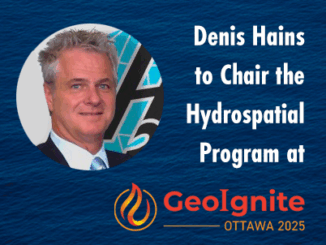
• facebook
  • Twitter
  • Linkedin
  • Youtube
  • Linkedin Group
  • Post a Job
  • Post an Ad
  • Post an Event
  • Post a Directory Listing
  • Post a Press Release
  • Media Kit
  • My Account
  • Login
GoGeomatics
  • MAGAZINE
    • BIM & GIS
    • Community
    • Conference news
    • Earth Observation
    • Education & Careers
    • GEOAI
    • Announcements
    • Reality Capture & Lidar
    • Science
    • Technology
    • Between the Poles
  • Directories
    • ASSOCIATION
    • INDUSTRY
    • EDUCATION
    • Open Data
  • EVENTS
    • GeoIgnite Events
    • Events Calendar
    • GoGeomatics Meetups
  • Services
    • Advertising
    • Marketing
    • Post a Job
    • Post an Ad
    • Post an Event
    • Post a Press Release
    • Post a Directory Listing
    • Media Kit
    • Web Design
  • Find a Job
  • Volunteer
    • Start a GoGeomatics Group
    • Editors & Writers Group
  • About Us
    • About Us
    • Contact Us
    • Frequently Asked Questions
  • Videos
HomeGeospatial Intelligence

Geospatial Intelligence

Community

Canada’s National RPAS Program Debuts at GoGeomatics Expo

22 July 2024 GoGeomatics Expo | accuracy

RPAS platforms and sensors have made significant strides since their commercial adoption almost a decade ago, quickly becoming essential tools for many professionals. This trend reflects the industry’s eagerness to embrace new technologies and apply […]

Technology

As Wildfires Rage, Canada Bolsters Wildfire Intelligence with Tech Advancements

6 June 2024 Anusuya Datta | Canadian Space Agency

As Canada heads into another wildfire season, the Canadian Safety and Security Program (CSSP) has announced a call for proposals to advance wildfire detection and suppression through innovative science and technology solutions. A key goal […]

Technology

GoGeomatics Picks the Most Important International Stories of 2023

17 January 2024 Volunteer Editors and Group Writers | Agricultural development

Saeideh’s pick: Interactive map shows where your food comes from Jonathan’s Pick: Canada’s National Geomatics Expo Jake’s pick: Mapping the conflict between farming and biodiversity George’s pick: The most detailed and comprehensive publicly available large-scale […]

Technology

International Geospatial Digest September 25, 2023

25 September 2023 Volunteer Editors and Group Writers | agriculture

Mapping Indigenous Knowledge to Protect Congo Basin Diversity Singapore taps Lidar and laser scanning in remote building inspections Satellites reveal how deadly Morocco earthquake moved ground Putting Poverty Back on the Map: Introducing the World […]

Technology

International Geospatial Digest September 11th, 2023

11 September 2023 Volunteer Editors and Group Writers | AI

Planning Landmine clearances with UAV LiDAR Mapping pollution from space Tracking dangerous chemicals in the Great Lakes with maps New Google Maps API helps with mapping pollen, solar, and air quality. Understanding geospatial intelligence Planning […]

Newsmakers & Press Releases

MDA Platinum Sponsor of Canada’s National Geospatial Event: GeoIgnite 2021

12 January 2021 GoGeomatics Canada | April 2021

Canadian Leadership & Geospatial Intelligence  GeoIgnite invites the geospatial community to engage with one another by sharing your work, services, and data at our third annual conference.  Download the sector participation package PDF. One month […]

piggy bank|||||||
Education & Careers

Five Free and Cheap Ways to Improve Your Geospatial Technology Skills and Learn GIS to Advance Your Career

10 September 2020 Elizabeth McCready | agile development

You don’t have to spend a lot of money or go back to university or college to learn or improve your GIS and Geospatial Technology Skills It’s a competitive job market, but updating your technology […]

|||
Technology

PCI Geomatics presents free user group meeting on June 17th, 2019, from 1pm-5pm in Ottawa

24 May 2019 Kevin Jones | Data analytics

PCI Geomatics is pleased to announce that we are hosting a free user group meeting on June 17th, 2019, from 1pm-5pm in Ottawa. We will be showing our latest technology, many of our staff will […]

Posts pagination

« 1 … 5 6 7 8 »

Events

Notice
There are no upcoming events.

View All Events

Services

  • Post a Job
  • Post an Ad
  • Post an Event
  • Post a Directory Listing
  • Post a Press Release
  • Media Kit
  • My Account
  • Login

Jobs

Post a Job
  • Operations Spatial Data Assistant (Contract)
    Vaughan
  • GIS Analyst
    Saint John, New Brunswick
  • GIS Student Intern
    Elmsdale, Nova Scotia
  • Canada Impact+ Research Chair – Professor (Or Associate Professor)
    Lethbridge, Alberta
View All Jobs
  • Directories
    • Associations Directory
    • Industry Directory
    • Education Programs
    • Open Data
  • Volunteer
    • Start a GoGeomatics Group
    • Editors & Writers Group
  • About Us
    • GoGeomatics Media Kit
    • Who We Are
    • Contact Us
    • FAQ’s
    • Advertising
    • Marketing
  • Subscribe
GoGeomatics
GoGeomatics is the largest and most popular communications hub promoting the Canadian geospatial community. The business was incorporated in 2011. GoGeomatics hosts over 100 fun, free, location technology networking events each year in cities across Canada.

© 2026 GoGeomatics

  • facebook
  • Twitter
  • Linkedin
  • Youtube
  • Linkedin Group