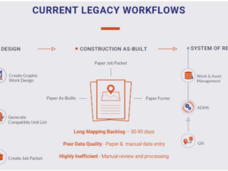
The Evolution of Mapping Disease
The current pandemic is highlighting how important GIS is in understanding and interpreting data. History shows the evolution of GIS for mapping disease and the unique ways in which it can be used. Cholera, 1854 […]
The GIS & LiDAR Specialist I am Kei, a passionate GIS & LiDAR Specialist with over 6 years’ experience in Japan, currently living in Canada and looking to continue my career here. As I have […]
GoGeomatics Canada is excited to introduce our new volunteer managers to the team this March. Our community managers are the ones writing the stories and organizing the content behind the scenes. The community managers have […]
The GIS market has grown in size every year for the past decade. With a current capitalization of over USD 8 billion, the industry is expected to reach USD 14.5 billion by 2025. This is […]
Calling all Canadian GIS students! Through the GIS Scholarships program, Esri Canada recognizes Canadian post-secondary institutions that deliver strong, multidisciplinary GIS courses and programs. Students from 60 colleges and universities across the country are eligible […]
Social Distancing and Illegal Assemblies The coronavirus pandemic is changing our living habits. Social distancing measures have been implemented to limit the size of gatherings for months, however illegal private assemblies were reported constantly despite […]
Canadian Leadership & Geospatial Intelligence GeoIgnite invites the geospatial community to engage with one another by sharing your work, services, and data at our third annual conference. Download the sector participation package PDF. One month […]
Nowadays, satellite remote sensing comes in handy and can now be employed in our day-to-day activities. This technology, with the assistance of GPS and GIS, provides tools and analysis relevant to real-time road mapping and […]