• facebook
  • Twitter
  • Linkedin
  • Youtube
  • Linkedin Group
  • Post a Job
  • Post an Ad
  • Post an Event
  • Post a Directory Listing
  • Post a Press Release
  • Media Kit
  • My Account
  • Login
GoGeomatics
  • MAGAZINE
    • BIM & GIS
    • Community
    • Conference news
    • Earth Observation
    • Education & Careers
    • GEOAI
    • Announcements
    • Reality Capture & Lidar
    • Science
    • Technology
  • Directories
    • ASSOCIATION
    • INDUSTRY
    • EDUCATION
    • Open Data
  • EVENTS
    • GeoIgnite Events
    • Events Calendar
    • GoGeomatics Meetups
  • Services
    • Advertising
    • Marketing
    • Post a Job
    • Post an Ad
    • Post an Event
    • Post a Press Release
    • Post a Directory Listing
    • Media Kit
    • Web Design
  • Find a Job
  • Volunteer
    • Start a GoGeomatics Group
    • Editors & Writers Group
  • About Us
    • About Us
    • Contact Us
    • Frequently Asked Questions
  • Videos
HomeLiDAR contracts

LiDAR contracts

||||||
Technology

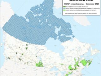
CANADA’S NATIONAL ELEVATION DATA STRATEGY UPDATE NOVEMBER 2022

23 November 2022 David Belanger | Auto-building system

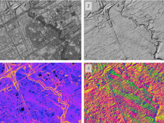
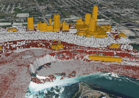
Fall 2022 LIDAR ACQUISITIONS 2022 IN SUPPORT OF THE FLOOD HAZARD IDENTIFICATION AND MAPPING PROGRAM (FHIMP) Flood hazard maps are essential to understanding a community’s risk to flooding. In Canada, many flood maps are not […]

|||
Technology

CANADA’S NATIONAL ELEVATION DATA STRATEGY UPDATE

9 January 2022 David Belanger | Auto-building system

Fall 2021 LIDAR ACQUISITIONS 2021 The 2021 LiDAR acquisition period is already coming to an end. In addition to integrating data from several organizations across the country, the Canada Centre for Mapping and Earth Observation […]

||||||||
Technology

NATIONAL ELEVATION DATA STRATEGY UPDATE

2 September 2020 David Belanger | 2020

July 2020 STATUS OF THE LIDAR ACQUISITIONS The National Elevation Data Strategy team of the Canadian Centre for Mapping and Earth Observation (CCMEO) continues its work to provide Canadians with an accurate three-dimensional representation of […]

|||
Technology

CANADA’S NATIONAL ELEVATION DATA STRATEGY UPDATE

4 December 2019 David Belanger | 2020

November 2019 HRDEM FOR THE ENTIRE CANADIAN ARCTIC! In August, Natural Resources Canada (NRCan) made available a new release of the High Resolution Digital Elevation Model (HRDEM) product for the entire Canadian Arctic! This new 2 m data […]

Events

Notice
There are no upcoming events.

View All Events

Services

  • Post a Job
  • Post an Ad
  • Post an Event
  • Post a Directory Listing
  • Post a Press Release
  • Media Kit
  • My Account
  • Login

Jobs

Post a Job
  • Canada Maps and Poster Gallery Volunteer Leads — GeoIgnite 2026
    remote
  • GIS & Data Analytics Lead
    Beaumont, AB
  • Lead Surveyor, Projects/Arpenteur-géomètre principal, projets; arpenteuse-géomètre principale, projets
    North Bay, Thunder Bay
  • Senior GIS Developer
    Calgary, AB
View All Jobs
  • Directories
    • Associations Directory
    • Industry Directory
    • Education Programs
    • Open Data
  • Volunteer
    • Start a GoGeomatics Group
    • Editors & Writers Group
  • About Us
    • GoGeomatics Media Kit
    • Who We Are
    • Contact Us
    • FAQ’s
    • Advertising
    • Marketing
  • Subscribe
GoGeomatics
GoGeomatics is the largest and most popular communications hub promoting the Canadian geospatial community. The business was incorporated in 2011. GoGeomatics hosts over 100 fun, free, location technology networking events each year in cities across Canada.

© 2025 GoGeomatics

  • facebook
  • Twitter
  • Linkedin
  • Youtube
  • Linkedin Group