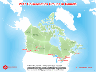
• facebook
  • Twitter
  • Linkedin
  • Youtube
  • Linkedin Group
  • Post a Job
  • Post an Ad
  • Post an Event
  • Post a Directory Listing
  • Post a Press Release
  • Media Kit
  • My Account
  • Login
GoGeomatics
  • MAGAZINE
    • BIM & GIS
    • Community
    • Conference news
    • Earth Observation
    • Education & Careers
    • GEOAI
    • Announcements
    • Reality Capture & Lidar
    • Science
    • Technology
  • Directories
    • ASSOCIATION
    • INDUSTRY
    • EDUCATION
    • Open Data
  • EVENTS
    • GeoIgnite Events
    • Events Calendar
    • GoGeomatics Meetups
  • Services
    • Advertising
    • Marketing
    • Post a Job
    • Post an Ad
    • Post an Event
    • Post a Press Release
    • Post a Directory Listing
    • Media Kit
    • Web Design
  • Find a Job
  • Volunteer
    • Start a GoGeomatics Group
    • Editors & Writers Group
  • About Us
    • About Us
    • Contact Us
    • Frequently Asked Questions
  • Videos
Homemap

map

||
Technology

Outil de versionnement des données géographiques à code source ouvert pour des environnements multi-contributeurs (partie 1)

15 March 2017 Nicolas Gignac | 2014

Note des éditeurs : Cet article a été écrit conjointement par Nicolas Gignac, Dami Sonoiki (eHealth Africa) et Samuel Aiyeoribe (eHealth Africa). Ces auteurs aimeraient remercier Yves Moisan, Vincent Mora (Oslandia) et Vincent Picavet (Oslandia) pour leur support et […]

|
Newsmakers & Press Releases

URISA BC: Vancouver Call for Presentations on GIS Trends in Community Engagement

13 March 2017 GoGeomatics Newsmakers | 2017

Call for Presentations Following the success of our December event, the URISA BC Executive Team is busy planning our next seminar for the Vancouver Marriott Pinnacle Downtown. Join us in mid-June, 2017 for URISA BC’s […]

Newsmakers & Press Releases

CCA Ottawa Conference: “150 Years of Cartography: Past, Present and Future”

13 March 2017 GoGeomatics Newsmakers | 2017

The 42nd Annual Conference of the Canadian Cartographic Association “150 Years of Cartography: Past, Present and Future” Location: Carleton University, Ottawa, ON – River Building Date: Wednesday, May 31 – Friday, June 2, 2017 This […]

Newsmakers & Press Releases

Free Webinar March 15th: NRCan, OGC, & USGS Arctic Spatial Data Pilot Demonstration

10 March 2017 GoGeomatics Newsmakers | 2017

The Canada Centre for Mapping and Earth Observation invites you to attend the Arctic Spatial Data Pilot Demonstration Webinar. Managed and organised by the Open Geospatial Consortium (OGC), the Pilot is sponsored by NRCan (Canada Centre […]

|
Newsmakers & Press Releases

Toronto & Calgary: Federal Floodplain Mapping Workshop March 28th & 30th

9 March 2017 GoGeomatics Newsmakers | 2017

The Federal Floodplain Mapping Guidelines workshop, hosted by Canadian Water Resources Association (CWRA) on behalf of the Government of Canada, has been arranged in order to present and gather input regarding the recently developed Federal […]

||BC Pinot Noir Map enlarged section|BC Pinot Noir Map
Technology

GIS in Action: How Does BC Pinot Noir Express Terroir?

8 March 2017 Karl Kliparchuk | 2012

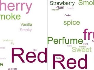
Editors note: In this previously published article, Karl Kliparchuk, BCIT GIS Program Head & Instructor uses GIS to explore the aromas and flavors of wine from British Columbia, Canada. We are breaking down BC wine […]

No Picture
Community

Top Ten Climate Change Maps and GIS Applications

7 March 2017 Priscilla Ancinelli | agriculture

Awareness for climate change has been steadily increasing ever since the Green Revolution in the 1960s. There is a plethora of data, maps, and Geographic Information Systems (GIS) applications available freely or accessible to the […]

Eastern Canada|||
Education & Careers

Grand Banks to the Gulf of Mexico: My Canadian Geomatics Career

2 March 2017 Jim Strowbridge | 2013

I often contemplate what it would have been like working at the same job for an entire career. Mind you, the thought of the same job day in and day out never appealed to me. I’m […]

Posts pagination

« 1 … 14 15 16 … 76 »

Events

Notice
There are no upcoming events.

View All Events

Services

  • Post a Job
  • Post an Ad
  • Post an Event
  • Post a Directory Listing
  • Post a Press Release
  • Media Kit
  • My Account
  • Login

Jobs

Post a Job
  • Canada Maps and Poster Gallery Volunteer Leads — GeoIgnite 2026
    remote
  • SENIOR PLANNER SPATIAL ANALYSIS SIPA
    Toronto, ON
  • Data & GIS Specialist, Exploration
    Toronto, ON
  • Geospatial Technical Support and Training Specialist
    Ontario, Canada
View All Jobs
  • Directories
    • Associations Directory
    • Industry Directory
    • Education Programs
    • Open Data
  • Volunteer
    • Start a GoGeomatics Group
    • Editors & Writers Group
  • About Us
    • GoGeomatics Media Kit
    • Who We Are
    • Contact Us
    • FAQ’s
    • Advertising
    • Marketing
  • Subscribe
GoGeomatics
GoGeomatics is the largest and most popular communications hub promoting the Canadian geospatial community. The business was incorporated in 2011. GoGeomatics hosts over 100 fun, free, location technology networking events each year in cities across Canada.

© 2025 GoGeomatics

  • facebook
  • Twitter
  • Linkedin
  • Youtube
  • Linkedin Group