• facebook
  • Twitter
  • Linkedin
  • Youtube
  • Linkedin Group
  • Post a Job
  • Post an Ad
  • Post an Event
  • Post a Directory Listing
  • Post a Press Release
  • Media Kit
  • My Account
  • Login
GoGeomatics
  • MAGAZINE
    • BIM & GIS
    • Community
    • Conference news
    • Earth Observation
    • Education & Careers
    • GEOAI
    • Announcements
    • Reality Capture & Lidar
    • Science
    • Technology
    • Between the Poles
  • Directories
    • ASSOCIATION
    • INDUSTRY
    • EDUCATION
    • Open Data
  • EVENTS
    • GeoIgnite Events
    • Events Calendar
    • GoGeomatics Meetups
  • Services
    • Advertising
    • Marketing
    • Post a Job
    • Post an Ad
    • Post an Event
    • Post a Press Release
    • Post a Directory Listing
    • Media Kit
    • Web Design
  • Find a Job
  • Volunteer
    • Start a GoGeomatics Group
    • Editors & Writers Group
  • About Us
    • About Us
    • Contact Us
    • Frequently Asked Questions
  • Videos
Homemapping

mapping

BIM & GIS

Reference Systems in Transition: A Wake-Up Call for the Geodesy Crisis

25 June 2025 Benedicta Antwi Boasiako | Canada

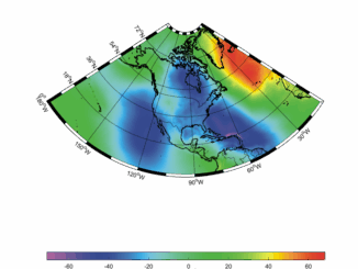
The North American geodetic community is on the brink of a major shift, one that promises improved positional accuracy and stronger cross-border alignment. But beneath the progress lies an unsettling reality: the very systems enabling […]

Community

Dyslexia in STEM: Rethinking Inclusion in the Geospatial Classroom and Workplace

25 June 2025 Benedicta Antwi Boasiako | community

At this year’s SaGES conference, one of the most quietly powerful moments came from a session that had nothing to do with remote sensing algorithms or cartographic frameworks. Instead, it focused on people, specifically, learners […]

Community

Canadian Geospatial Digest June 23, 2025

23 June 2025 Volunteer Editors and Group Writers | Charter

UBC Okanagan Student Develops Canadian Wildfire Application Flood Mapping will Increase the Number of Quebec Homes in Flood Zones A New Digital Mapping Tool for Ottawa’s Traffic Infrastructure New RFP from the Canada Govt Looks […]

BIM & GIS

Preserving Nature’s Balance: How Prince Edward Island Leads with Environmental Mapping

20 June 2025 Alefiya Dungrawala | Canada

The protection of the environment and wildlife is not merely a moral imperative but a critical necessity for sustaining life on Earth. As human activity accelerates climate change, habitat destruction, and species extinction, the balance […]

Conference news

Navigating the Future: Generative AI for Enhanced Geospatial Data Quality on AWS

15 June 2025 Farzaneh Farshad | AI

At this year’s GeoIgnite conference, Amazon Web Services (AWS) delivered one of the most forward-looking presentations in the geospatial track. In a session titled “Navigating the Future: Generative AI for Enhanced Geospatial Data Quality,” Phil […]

Allen Carrol
BIM & GIS

The Mapmaker’s Journey: Allen Carroll on Storytelling, Cartography, and His New Book

12 June 2025 Anusuya Datta | Allen Carroll

On June 10, Allen Carroll’s new book Telling Stories with Maps, was launched, shedding light on the evolving role of maps in storytelling. As the founder of Esri StoryMaps and former Chief Cartographer at National […]

Community

The New Geospatial Imperative: Luc Vaillancourt on Clarity, Value, and User-Centric Innovation

12 June 2025 Alefiya Dungrawala | BALIZ

At GeoIgnite 2025 in Ottawa, Luc Vaillancourt, founder of BALIZ, delivered one of the event’s most thought-provoking talks: “Two Solitudes in Geomatics.” Drawing inspiration from Canadian literature and culture, Vaillancourt used the metaphor of “two […]

Other

Taking Control of Canada’s Digital Sovereignty with Open-Source GIS

10 June 2025 Anusuya Datta | Canada

(This is the second part of our series, following the article exploring France’s success with open-source GIS) Canada’s geospatial systems are at a crossroads. Technology is moving fast, and the pressure is on for more efficient, […]

Posts pagination

« 1 … 9 10 11 … 79 »

Events

Notice
There are no upcoming events.

View All Events

Services

  • Post a Job
  • Post an Ad
  • Post an Event
  • Post a Directory Listing
  • Post a Press Release
  • Media Kit
  • My Account
  • Login

Jobs

Post a Job
  • Operations Spatial Data Assistant (Contract)
    Vaughan
  • GIS Analyst
    Saint John, New Brunswick
  • GIS Student Intern
    Elmsdale, Nova Scotia
  • Canada Impact+ Research Chair – Professor (Or Associate Professor)
    Lethbridge, Alberta
View All Jobs
  • Directories
    • Associations Directory
    • Industry Directory
    • Education Programs
    • Open Data
  • Volunteer
    • Start a GoGeomatics Group
    • Editors & Writers Group
  • About Us
    • GoGeomatics Media Kit
    • Who We Are
    • Contact Us
    • FAQ’s
    • Advertising
    • Marketing
  • Subscribe
GoGeomatics
GoGeomatics is the largest and most popular communications hub promoting the Canadian geospatial community. The business was incorporated in 2011. GoGeomatics hosts over 100 fun, free, location technology networking events each year in cities across Canada.

© 2026 GoGeomatics

  • facebook
  • Twitter
  • Linkedin
  • Youtube
  • Linkedin Group