
Community
Esri Canada User Conference Toronto 2012
As this is my first article with GoGeomatics Canada, I would like to start off by saying a warm hello to the readers out there who enjoy everything GIS related. To give you a brief […]
As this is my first article with GoGeomatics Canada, I would like to start off by saying a warm hello to the readers out there who enjoy everything GIS related. To give you a brief […]
Microsoft Launches Beta Testing Program to Achieve Laserless Point Clouds In July 2012 Microsoft announced the launch of its beta testing program for UltraMap Version 3.0. For those unfamiliar with UltraMap, it is the factory […]

GoGeomatics: Welcome to the GoGeomatics Canada community. To begin, can you tell us where you are from and where you have lived throughout your GIS career? Sheila Churchill: I live in Vancouver, British Columbia, I […]

I believed in 1996 that the future of geography was with technology and I still believe that even more so today. Geography is alive and well in the real world because of technical geography despite […]
Last week was a big week in the web and mobile mapping world on at least two fronts. First, Amazon announced plans to release a mapping API to support the Kindle Fire HD. That alone […]
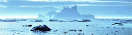
Canada’s north has always been a challenge to those living there and to geoscience professionals alike. The sheer size of the arctic and extreme cold have resulted in difficult access and contributed toward significant challenges […]
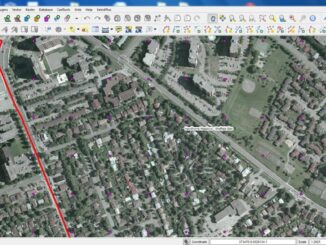
The City of Ottawa Official Plan set a target of 30% tree canopy cover for the entire city. To the author’s knowledge there is no information on the amount of tree canopy for the entire […]
GoGeomatics Canada is talking to Dave MacLean – a member of the GIS Faculty at the Centre of Geographic Sciences (COGS) in Lawrencetown, Nova Scotia. GoGeomatics: Welcome to the GoGeomatics Canada community. To get started, […]