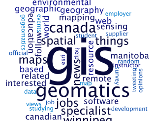
market

How Canadian Remote Sensing Was Made Commercially Successful & Exportable

This piece started as a note on some of my experience as an international consultant in remote sensing specifically and…

CIG Advancements in Geomatics 2016 Conference in New Brunswick Sept 26th-28th

Advancements in Geomatics – Research and Collaboration for Informed Decisions in a Changing World The Canadian Institute of Geomatics (CIG)…

Jessi Mielke Esri’s Certification Manager Chats About the Esri Technical Certification Program

For the last 6 months I’ve been writing articles and discussing my experience in regards to the Esri technical certification…

MDA signs contracts for RADARSAT-2 information

Richmond, BC – MacDonald, Dettwiler and Associates Ltd. (“MDA” or the “Company”) (TSX: MDA), a global communications and information company,…

RouteMagic: A Unique Way of Mapping Your Bike Route

Always at the forefront, the CycleMap application is revolutionising how people plan their bike rides with its RouteMagic, a new…

Indoor Mapping Platform Jibestream Named as Fast Growing IoT Company

Toronto: Jibestream announced it has been named among the 30 Fastest Growing IoT Companies for 2016. Improving efficiency, productivity and…

EMSA expands use of RADARSAT-2 information for maritime applications

MacDonald, Dettwiler and Associates Ltd. a global communications and information company announced that it has signed a four year contract…

The Most Fun You’ve had with Geomatics: ‘Pokémon Go’ Comes to Canada

The geospatial community has been “abuzz” since a game called called “Pokémon Go” landed on cell phones in Australia and…

Keystone Aerial Surveys, Inc. optimizes efficiency with Optech Galaxy

Teledyne Optech is pleased to announce that Keystone Aerial Surveys, Inc. has accepted delivery of the most capable airborne lidar…

MDA delivers maritime surveillance system using RADARSAT Constellation Mission

Richmond, BC – MacDonald, Dettwiler and Associates Ltd. (“MDA” or the “Company”) (TSX: MDA), a global communications and information company,…

Drone World Expo Conference Program Will Provide a Road Map for Commercial Drone Solutions

A world-class conference program and several new educational and networking features will take place at the 2nd annual Drone World…

TECTERRA Funds $4.9 Million for Geomatics Innovation in Canada in 2015-16

TECTERRA Inc. announced it had committed $4.9 million of funds to support the geomatics technology sector in Canada during the…