• facebook
  • Twitter
  • Linkedin
  • Youtube
  • Linkedin Group
  • Post a Job
  • Post an Ad
  • Post an Event
  • Post a Directory Listing
  • Post a Press Release
  • Media Kit
  • My Account
  • Login
GoGeomatics
  • MAGAZINE
    • BIM & GIS
    • Community
    • Conference news
    • Earth Observation
    • Education & Careers
    • GEOAI
    • Announcements
    • Reality Capture & Lidar
    • Science
    • Technology
  • Directories
    • ASSOCIATION
    • INDUSTRY
    • EDUCATION
    • Open Data
  • EVENTS
    • GeoIgnite Events
    • Events Calendar
    • GoGeomatics Meetups
  • Services
    • Advertising
    • Marketing
    • Post a Job
    • Post an Ad
    • Post an Event
    • Post a Press Release
    • Post a Directory Listing
    • Media Kit
    • Web Design
  • Find a Job
  • Volunteer
    • Start a GoGeomatics Group
    • Editors & Writers Group
  • About Us
    • About Us
    • Contact Us
    • Frequently Asked Questions
  • Videos
Homemodel

model

||
Education & Careers

What are the Top Programming Languages in the GIS World?

16 November 2016 Florin-Daniel Cioloboc | 2016

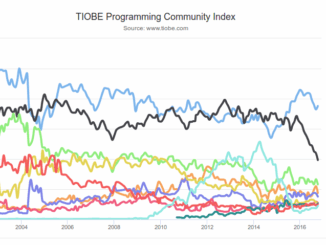
Image source: www.tiobe.com Every now and again we hear about the importance of programming for Geographic Information Systems(GIS) professionals, that is quickly becoming a key in the evolution of one’s career. It is argued that […]

|||||||
Community

Operational GIS Jobs in the Canadian Military

7 November 2016 Richard Davenport | aerial

Whether its businesses, governments or for personal use, Geomatics offers everyday solutions to the worlds questions. The Canadian Armed Forces is no exception. These highly trained and dedicated Geo Techs  are members of the Military […]

Newsmakers & Press Releases

New Brunswick: CARIS Announces release of HIPS and SIPS™ 10

1 November 2016 GoGeomatics Newsmakers | 2016

Fredericton, NB, Canada – November 01, 2016 – Teledyne CARIS™ is pleased to announce the release of HIPS and SIPS™ 10. This release introduces exciting new capabilities for automation, efficiency, and usability through the integration of […]

Newsmakers & Press Releases

Montreal: SimActive Offers Free Trial of UAV Software

11 October 2016 GoGeomatics Newsmakers | 2016

Montreal, Canada, October 11th, 2016 – SimActive Inc., a world-leading developer of photogrammetry software, is pleased to announce a new subscription-based offering for Correlator3D™ UAV. The rental option allows users with a dynamic workload to […]

|
Newsmakers & Press Releases

DigitalGlobe’s Basemap Suite Expands: 250 Million Square Kilometers of 30 cm Imagery

4 October 2016 GoGeomatics Newsmakers | accuracy

DigitalGlobe, Inc. (NYSE: DGI), the global leader in Earth imagery and information about our changing planet, today announced that its online Basemap Suite has reached a significant milestone, with the availability of more than 250 […]

||||
Community

GoGeomatics Kelowna: September Success & October Social With Talk from Esri Canada

4 October 2016 Dianne Gray | analytics

GoGeomatics Kelowna’s first Back-to-School September social was a huge success!    Among the attendees were a great group from Stantec, our local Kelowna GoGeomatics sponsor, and 2 members of Esri Canada, our nation-wide GoGeomatics sponsor.   Other […]

||
Education & Careers

UAVs in Canada – Key Exposures to Loss and Ways to Protect Yourself

3 October 2016 Association of Ontario Land Surveyors | 2014

This article was written by Mark Sampson for the Association of Ontario Land Surveyors. Mark’s contact details are at the bottom of the article and here is a direct link. Drones are referred to interchangeably […]

|||||||||
Community

50 Years a Geographer: My Top Ten books about Geography

20 September 2016 Robert Maher | 2015

In celebration of Geography Week, it seemed like a good idea to issue a challenge: list the top ten books about Geography ever written. It was modelled on a similar list for History. This is […]

Posts pagination

« 1 … 3 4 5 … 27 »

Events

Notice
There are no upcoming events.

View All Events

Services

  • Post a Job
  • Post an Ad
  • Post an Event
  • Post a Directory Listing
  • Post a Press Release
  • Media Kit
  • My Account
  • Login

Jobs

Post a Job
  • Canada Maps and Poster Gallery Volunteer Leads — GeoIgnite 2026
    remote
  • GIS & Data Analytics Lead
    Beaumont, AB
  • Lead Surveyor, Projects/Arpenteur-géomètre principal, projets; arpenteuse-géomètre principale, projets
    North Bay, Thunder Bay
  • Senior GIS Developer
    Calgary, AB
View All Jobs
  • Directories
    • Associations Directory
    • Industry Directory
    • Education Programs
    • Open Data
  • Volunteer
    • Start a GoGeomatics Group
    • Editors & Writers Group
  • About Us
    • GoGeomatics Media Kit
    • Who We Are
    • Contact Us
    • FAQ’s
    • Advertising
    • Marketing
  • Subscribe
GoGeomatics
GoGeomatics is the largest and most popular communications hub promoting the Canadian geospatial community. The business was incorporated in 2011. GoGeomatics hosts over 100 fun, free, location technology networking events each year in cities across Canada.

© 2025 GoGeomatics

  • facebook
  • Twitter
  • Linkedin
  • Youtube
  • Linkedin Group