• facebook
  • Twitter
  • Linkedin
  • Youtube
  • Linkedin Group
  • Post a Job
  • Post an Ad
  • Post an Event
  • Post a Directory Listing
  • Post a Press Release
  • Media Kit
  • My Account
  • Login
GoGeomatics
  • MAGAZINE
    • BIM & GIS
    • Community
    • Conference news
    • Earth Observation
    • Education & Careers
    • GEOAI
    • Announcements
    • Reality Capture & Lidar
    • Science
    • Technology
  • Directories
    • ASSOCIATION
    • INDUSTRY
    • EDUCATION
    • Open Data
  • EVENTS
    • GeoIgnite Events
    • Events Calendar
    • GoGeomatics Meetups
  • Services
    • Advertising
    • Marketing
    • Post a Job
    • Post an Ad
    • Post an Event
    • Post a Press Release
    • Post a Directory Listing
    • Media Kit
    • Web Design
  • Find a Job
  • Volunteer
    • Start a GoGeomatics Group
    • Editors & Writers Group
  • About Us
    • About Us
    • Contact Us
    • Frequently Asked Questions
  • Videos
HomeMosaic

Mosaic

|||||||||||||||||||||
Technology

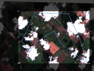
No more blind zones with the Mosaic feature

22 September 2019 GoGeomatics Newsmakers | AOI

Undoubtedly the best case scenario while working with satellite imagery is to find the most suitable images for your use-case from, let’s say, Sentinel-2 or Landsat-8, which reliably covers your area of interest (AOI); therefore […]

|||||||||||||||
Technology

UAV Surveys – How to Ensure Accuracy and Precision

12 April 2017 Thomas Hoppe | accuracy

For the past four years, I’ve been involved with the capture and delivery of data derived from drones. My experience has provided me with a good perspective on the quality of the data that can be […]

|||||||||||||||||||||
Education & Careers

My COGS GIS Education, Part II

22 March 2017 Richard Davenport | 2012

In my first article, I introduced the how and why I chose to attend COGS from the fall of 2014 to spring 2016. In Part 2, I wanted to give some insight into the first-year […]

Newsmakers & Press Releases

New Brunswick: CARIS Announces release of HIPS and SIPS™ 10

1 November 2016 GoGeomatics Newsmakers | 2016

Fredericton, NB, Canada – November 01, 2016 – Teledyne CARIS™ is pleased to announce the release of HIPS and SIPS™ 10. This release introduces exciting new capabilities for automation, efficiency, and usability through the integration of […]

Newsmakers & Press Releases

Montreal: SimActive Offers Free Trial of UAV Software

11 October 2016 GoGeomatics Newsmakers | 2016

Montreal, Canada, October 11th, 2016 – SimActive Inc., a world-leading developer of photogrammetry software, is pleased to announce a new subscription-based offering for Correlator3D™ UAV. The rental option allows users with a dynamic workload to […]

|
Newsmakers & Press Releases

DigitalGlobe’s Basemap Suite Expands: 250 Million Square Kilometers of 30 cm Imagery

4 October 2016 GoGeomatics Newsmakers | accuracy

DigitalGlobe, Inc. (NYSE: DGI), the global leader in Earth imagery and information about our changing planet, today announced that its online Basemap Suite has reached a significant milestone, with the availability of more than 250 […]

No Picture
Newsmakers & Press Releases

Airobotics Selects SimActive’s Photogrammetry Software for its Automated Industrial Drone Solution

30 August 2016 GoGeomatics Newsmakers | 2016

Montreal, Canada, August 30th, 2016 – SimActive Inc., a world-leading developer of photogrammetry software, is pleased to announce that Airobotics has chosen Correlator3D™ for its drone platforms. The software will be used to derive mapping […]

No Picture
Newsmakers & Press Releases

PCI Geomatics Delivers High Volume Production System (GXL) to Skymap Global in Singapore

25 May 2016 GoGeomatics Newsmakers | 2016

MARKHAM, Ontario, Canada—May 25, 2016: PCI Geomatics, a world leading developer of remote sensing and photogrammetric software and systems, announced today that SkyMap Global of Singapore has become a key commercial GXL customer in Asia. […]

Posts pagination

1 2 … 6 »

Events

Notice
There are no upcoming events.

View All Events

Services

  • Post a Job
  • Post an Ad
  • Post an Event
  • Post a Directory Listing
  • Post a Press Release
  • Media Kit
  • My Account
  • Login

Jobs

Post a Job
  • Canada Maps and Poster Gallery Volunteer Leads — GeoIgnite 2026
    remote
  • GIS & Data Analytics Lead
    Beaumont, AB
  • Lead Surveyor, Projects/Arpenteur-géomètre principal, projets; arpenteuse-géomètre principale, projets
    North Bay, Thunder Bay
  • Senior GIS Developer
    Calgary, AB
View All Jobs
  • Directories
    • Associations Directory
    • Industry Directory
    • Education Programs
    • Open Data
  • Volunteer
    • Start a GoGeomatics Group
    • Editors & Writers Group
  • About Us
    • GoGeomatics Media Kit
    • Who We Are
    • Contact Us
    • FAQ’s
    • Advertising
    • Marketing
  • Subscribe
GoGeomatics
GoGeomatics is the largest and most popular communications hub promoting the Canadian geospatial community. The business was incorporated in 2011. GoGeomatics hosts over 100 fun, free, location technology networking events each year in cities across Canada.

© 2025 GoGeomatics

  • facebook
  • Twitter
  • Linkedin
  • Youtube
  • Linkedin Group