multibeam sonar
Mapping the Deep: Our map of the ocean remains a work in progress
These days, when you look at Google Maps, Google Earth, or other web maps you are probably left with the…
International Geospatial Briefing Nov 22: 1. Two million square km of the seafloor mapped. 2. Importance of marine geospatial data. 3. Using smartphones to map road potholes. 4. Into the metaverse. 5. The Geography of Mysteries. 6. Mapping our human footprint.
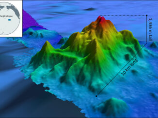
NOAA Ocean Exploration Meets Major Mapping Milestone on NOAA Ship Okeanos Explorer The National Oceanic and Atmospheric Administration (NOAA) has reached…
CIG Advancements in Geomatics 2016 Conference in New Brunswick Sept 26th-28th
Advancements in Geomatics – Research and Collaboration for Informed Decisions in a Changing World The Canadian Institute of Geomatics (CIG)…
Geomatics: Discovering history in Canada’s Arctic waters
This article was reprinted with permission from the Ontario Professional Surveyor, Volume 56, No. 3, Summer 2015 By Theresa Nicholsi,…
Government of Canada Unveils 3D Model of HMS Erebus
Data collected by the Department of Fisheries and Oceans’ Canadian Hydrographic Service used to develop models of HMS Erebus FREDERICTON,…
Andrew Hoggarth: CARIS Geospatial Software Solutions
GoGeomatics recently had the opportunity to talk with Andrew Hoggarth, Marketing and Sales Manager, CARIS . As a senior executive in the Geomatics industry, Andrew has a wealth of experience to share about CARIS and how his technical expertise has led him to a senior position in a business role.