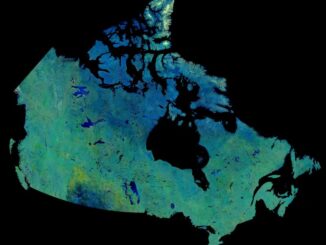
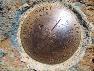
• facebook
  • Twitter
  • Linkedin
  • Youtube
  • Linkedin Group
  • Post a Job
  • Post an Ad
  • Post an Event
  • Post a Directory Listing
  • Post a Press Release
  • Media Kit
  • My Account
  • Shopping Cart
  • Login
GoGeomatics
  • MAGAZINE
    • BIM & GIS
    • Community
    • Conference news
    • Earth Observation
    • Education & Careers
    • GEOAI
    • Announcements
    • Reality Capture & Lidar
    • Science
    • Technology
    • Between the Poles
  • Directories
    • ASSOCIATION
    • INDUSTRY
    • EDUCATION
    • Open Data
  • EVENTS
    • GeoIgnite Events
    • Events Calendar
    • GoGeomatics Meetups
  • Services
    • Advertising
    • Marketing
    • Post a Job
    • Post an Ad
    • Post an Event
    • Post a Press Release
    • Post a Directory Listing
    • Media Kit
    • Web Design
  • Find a Job
  • Volunteer
    • Start a GoGeomatics Group
    • Editors & Writers Group
  • About Us
    • About Us
    • Contact Us
    • Frequently Asked Questions
  • Videos
HomeNatural Resources Canada

Natural Resources Canada

Digest Sept 29, 2025
BIM & GIS

Canadian Geospatial Digest – September 29, 2025

29 September 2025 Volunteer Editors and Group Writers | Arctic

Canada’s Defence Department Spending Millions on American Cloud Services RFI Seeks Information on Commercial SAR Imagery Acquisition Map Helps Highlight the Need to Preserve Canada’s Peatlands Industry-Government Partnership Shares RADARSAR-2 Data to Protect Rain Forests […]

BIM & GIS

NRCan and B.C. Lead Renewal of Canadian Geomatics Accord to 2030

25 September 2025 GoGeomatics Canada | AI in Geomatics

Natural Resources Canada (NRCan) has signed the renewal of the Canadian Geomatics Accord for 2025–2030 with the Government of British Columbia as co-chairs and first official signatories. The renewed Accord will continue to enable federal-provincial-territorial […]

Earth Observation

Inside the CSRS-PPP Galileo Update: Accuracy Gains and What’s Next

20 August 2025 Benedicta Antwi Boasiako | beidou

This article includes insights from Dr. Simon Banville, Senior Advisor for GNSS Products and Analysis at Natural Resources Canada and the technical lead behind this update. Canada’s Precise Point Positioning (PPP) tool has just undergone […]

Earth Observation

Canada Invests $11.7M in National Wildfire Centre of Excellence to Boost Innovation & Resilience

20 July 2025 GoGeomatics Canada | Canada

With wildfires impacting Canadians across the country, the federal government is taking action to prevent wildfires, mitigate their effects and boost resilience. The Government of Canada’s first priority is protecting Canadians and supporting those affected […]

GEOAI

Federal Government, NWT Launch AI Core Scanning Pilot for Critical Minerals

20 July 2025 GoGeomatics Canada | AI

The Government of Canada and the Government of the Northwest Territories are working together to advance a new geoscience research initiative that leverages artificial intelligence (AI), digital scanning technologies and historic drill cores to unlock […]

Cassidy Rankine
Earth Observation

Mapping Crisis in Real Time: Cassidy Rankine on How Planet is Powering Canada’s Climate Response

9 June 2025 Anusuya Datta | Agriculture and Agri-Food Canada

As Canada enters yet another year of severe and increasingly frequent climate events — from early-season wildfires to flash floods and coastal erosion — governments are under growing pressure to adapt faster and act smarter. […]

Conference news

Bridging Innovation and Impact: Eric Loubier on Canada’s AI + Earth Observation Future

20 May 2025 GoGeomatics Canada | AI tools

At a time when governments are grappling with climate risks, infrastructure demands, and digital transformation, Eric Loubier, Director General of the Canada Centre for Mapping and Earth Observation (CCMEO) at Natural Resources Canada (NRCan), delivered […]

National Glaciology Project|||||||Water Canada|Columbia Basin|Nrcan water model
Community

Securing Canada’s Water Resources in a Changing World

31 March 2025 David Legris | Canada

Water is crucial for all life on Earth, and as the planet increasingly feels the effects of climate change, freshwater is becoming an even more contentious issue. Canadians are fortunate to possess approximately 20% of […]

Posts pagination

« 1 2 3 … 10 »

Events

Notice
There are no upcoming events.

View All Events

Services

  • Post a Job
  • Post an Ad
  • Post an Event
  • Post a Directory Listing
  • Post a Press Release
  • Media Kit
  • My Account
  • Shopping Cart
  • Login

Jobs

Post a Job
  • Survey Technicians (Field and Office)
    Calgary, Alberta
  • Geospatial Analytical Technician / Technicien, analyses gĂ©ospatiales; technicienne, analyses gĂ©ospatiales
    Peterborough
  • Volunteer Editorial Contributor – Be Part of Canada’s Geomatics Story
    Remote
  • Jr. GIS Analyst
    Hamilton
View All Jobs
  • Directories
    • Associations Directory
    • Industry Directory
    • Education Programs
    • Open Data
  • Volunteer
    • Start a GoGeomatics Group
    • Editors & Writers Group
  • About Us
    • GoGeomatics Media Kit
    • Who We Are
    • Contact Us
    • FAQ’s
    • Advertising
    • Marketing
  • Subscribe
GoGeomatics
GoGeomatics is the largest and most popular communications hub promoting the Canadian geospatial community. The business was incorporated in 2011. GoGeomatics hosts over 100 fun, free, location technology networking events each year in cities across Canada.

© 2026 GoGeomatics

  • facebook
  • Twitter
  • Linkedin
  • Youtube
  • Linkedin Group