• facebook
  • Twitter
  • Linkedin
  • Youtube
  • Linkedin Group
  • Post a Job
  • Post an Ad
  • Post an Event
  • Post a Directory Listing
  • Post a Press Release
  • Media Kit
  • My Account
  • Login
GoGeomatics
  • MAGAZINE
    • BIM & GIS
    • Community
    • Conference news
    • Earth Observation
    • Education & Careers
    • GEOAI
    • Announcements
    • Reality Capture & Lidar
    • Science
    • Technology
  • Directories
    • ASSOCIATION
    • INDUSTRY
    • EDUCATION
    • Open Data
  • EVENTS
    • GeoIgnite Events
    • Events Calendar
    • GoGeomatics Meetups
  • Services
    • Advertising
    • Marketing
    • Post a Job
    • Post an Ad
    • Post an Event
    • Post a Press Release
    • Post a Directory Listing
    • Media Kit
    • Web Design
  • Find a Job
  • Volunteer
    • Start a GoGeomatics Group
    • Editors & Writers Group
  • About Us
    • About Us
    • Contact Us
    • Frequently Asked Questions
  • Videos
HomeNavVis VLX

NavVis VLX

Newsmakers & Press Releases

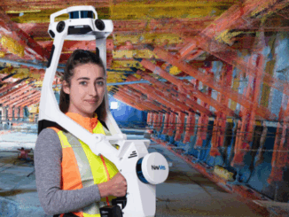
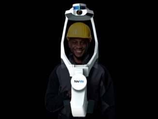
NavVis redefines handheld reality capture with the launch of NavVis MLX

10 September 2024 GoGeomatics Newsmakers | 3D reality capture

NavVis announces the launch of NavVis MLX, the first professional handheld dynamic scanning system that combines ergonomic design with high data quality. Munich, Germany – September 10, 2024: Today, NavVis, the global leader in reality […]

|||
Technology

NavVis’ Exciting Addition to Canadian Surveyors’ Toolkits

14 December 2022 Jon Murphy | Canada

New geomatics tech is always exciting when I come across it. So, it was doubly exciting to me that GoGeomatics was the first publication to announce the partnership between NavVis and Cansel to bring some […]

||
Technology

Does mobile mapping belong in surveying? These surveyors think so

27 September 2022 Sean Higgins | 3D Capture

By Sean Higgins  Two professional surveyors share three secret benefits of mobile mapping systems. Today, licensed surveyors are starting to put mobile mapping through its paces in projects like topo survey, building survey, bridge capture, […]

||||||||
Technology

Cansel Offers NavVis VLX Wearable Mobile Mapping Systems to Canadian Geospatial Market

21 September 2022 GoGeomatics Canada | 3D

Get ready, engineers, surveyors, and geospatial professionals. A new wearable mobile mapping system is coming to Canada, NavVis VLX. NavVis was introduced to Canada during a LiDAR Comex 2022 presentation, where NavVis was a Platinum […]

||||||||
Technology

NavVis Changes the Game with Dynamic Mobile Mapping

20 July 2022 GoGeomatics Canada | 3D Mapping

During a LiDAR COMEX 2022, live stream on April 5, 2022, participants heard Marek Koltun, Senior Account Executive – Enterprise and Partners for NavVis, speak on the topic of “Changing the game with Dynamic Mobile […]

Events

Notice
There are no upcoming events.

View All Events

Services

  • Post a Job
  • Post an Ad
  • Post an Event
  • Post a Directory Listing
  • Post a Press Release
  • Media Kit
  • My Account
  • Login

Jobs

Post a Job
  • Canada Maps and Poster Gallery Volunteer Leads — GeoIgnite 2026
    remote
  • GIS & Data Analytics Lead
    Beaumont, AB
  • Lead Surveyor, Projects/Arpenteur-géomètre principal, projets; arpenteuse-géomètre principale, projets
    North Bay, Thunder Bay
  • Senior GIS Developer
    Calgary, AB
View All Jobs
  • Directories
    • Associations Directory
    • Industry Directory
    • Education Programs
    • Open Data
  • Volunteer
    • Start a GoGeomatics Group
    • Editors & Writers Group
  • About Us
    • GoGeomatics Media Kit
    • Who We Are
    • Contact Us
    • FAQ’s
    • Advertising
    • Marketing
  • Subscribe
GoGeomatics
GoGeomatics is the largest and most popular communications hub promoting the Canadian geospatial community. The business was incorporated in 2011. GoGeomatics hosts over 100 fun, free, location technology networking events each year in cities across Canada.

© 2025 GoGeomatics

  • facebook
  • Twitter
  • Linkedin
  • Youtube
  • Linkedin Group