
Get ready, engineers, surveyors, and geospatial professionals. A new wearable mobile mapping system is coming to Canada, NavVis VLX.

NavVis was introduced to Canada during a LiDAR Comex 2022 presentation, where NavVis was a Platinum Sponsor, and has now found a partner in Cansel. A Canadian company, Cansel, which provides technology solutions to clients in surveying, engineering, utility, and construction industries, has announced a distribution agreement with NavVis, a German-based, leading developer of mobile mapping reality capture solutions. Cansel will now be the exclusive reseller of NavVis VLX systems throughout Canada.
Martin Trudelle, President of Cansel, said, ‘’The addition of NavVis to our portfolio of solutions is very aligned with our vision of innovation. At Cansel, we strive to be on top of the innovation wave with the ultimate goal to convert technology into measurable efficiency and profitability helping our clients realize quick ROI.’’
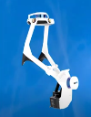
NavVis VLX accurately captures difficult sites as the user walks the area. It gathers data by using LiDAR sensors, Inertial Measurement Unit (IMU), 360-imagery from four cameras, and precision SLAM (Simultaneous Localization and Mapping) software. NavVis VLX delivers point cloud data 10 times faster than terrestrial 3D laser scanning systems.
“The NavVis VLX mobile mapping solution is capable of capturing geospatial data exponentially faster vs. traditional techniques. Vivid imagery is also acquired while maintaining cm-grade survey accuracy for all captured points. NavVis data can also be merged with data captured by most total stations and GNSS systems. Common survey deliverables such as curb lines, topo points and contours can then be created using most existing post-processing software platforms,” said Cansel’s Segment Manager-Terrestrial Scanning, Amar Kalsi.
The system’s dynamic scanning optimizes use in both indoor and outdoor areas. It is stable, fast, robust, and has an IP42 rating for dust and moisture. NavVis VLX captures high-quality cloud points and panoramas in a variety of conditions and environments. This system can be used in combination with equipment already in the industries, such as drones, terrestrial laser scanners, GPS/GNSS Rovers, and total stations.

Finn Boysen, Chief Revenue Officer at NavVis said, “We’re very happy to be partnering with Cansel, experts and innovators in the geospatial industry, to distribute our groundbreaking technology and software solutions in Canada. We understand how crucial field-to-finish efficiency and profitability are to the Canadian surveying market, and believe our tech is the perfect fit.”
A free webinar to demonstrate NavVis VLX will be held on October 5, 2022, at 1 pm EST or 10 am PST, by Cansel and NavVis. The demonstration will highlight the system’s features, while also demonstrating how it can save geospatial experts both time and rework.
Demonstrations of the NavVis VLX can be scheduled by visiting Cansel’s website.


Be the first to comment