Introduction: Why flood maps matter now
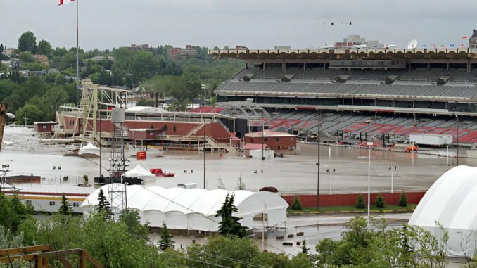
Flood occurs when water level rise beyond the threshold of rivers, lakes or oceans. Flooding is the most common natural hazard in Canada and the most expensive one, costing over $2 billion in insured catastrophic loss every year. For the past few decades, flooding has increased in frequency and intensity.
Across Canada, they can strike in any season — triggered by heavy rainfall, rapid snowmelt, ice jams, coastal storm surges, or strong onshore winds.
In this context, accurate and reliable flood risk maps are an urgent necessity. Such tools allow residents to know which areas are most likely to get flooded. In high-risk areas it is utmost important to understand their exposure to flooding, and are essential for public safety, infrastructure planning, insurance assessment, and emergency management.
However, a report released recently by the Commissioner of the Environment and Sustainable Development, on behalf of the Auditor General of Canada, found that Natural Resources Canada, Environment and Climate Change Canada, and Public Safety Canada have been slow to develop flood hazard maps — hampering Canada’s ability to adapt to climate change and adequately protect vulnerable communities.
What the Auditor General found
The 2026 report released by Commissioner of the Environment and Sustainable Development, Jerry V. DeMarco on behalf of the Office of the the Auditor General of Canada found that Natural Resources Canada, Environment and Climate Change Canada, and Public Safety Canada are not prepared to release the comprehensive flood hazard maps scheduled for 2028. The report also noted that existing maps fail to account for changing precipitation patterns driven by climate change.
According to Public Safety Canada, 80 per cent of Canadian cities are located on floodplains, including major cities such as Toronto, Montreal, Vancouver, Calgary, Edmonton, Ottawa, and Fredericton.
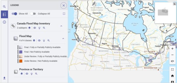
Canada currently has a flood risk tool, but it is not yet searchable because provinces and territories have not fully opted into the system. Quebec is developing its own mapping system, while Nunavut has requested more time to determine whether the tool aligns with its territorial requirements. Nova Scotia has opted out, citing concerns over the lack of details about how the tool would be introduced to the public. British Columbia has expressed support for a flood risk finder but says it will make a final decision after further assessment of the tool.
A comprehensive and accessible flood risk tool could help raise public awareness and reduce misconceptions about the impact of flood mapping on property values. By understanding the flood risks associated with their homes, property owners would be better positioned to take preventive measures, such as upgrading drainage systems, improving landscaping, or renovating vulnerable parts of their homes to reduce potential damage.
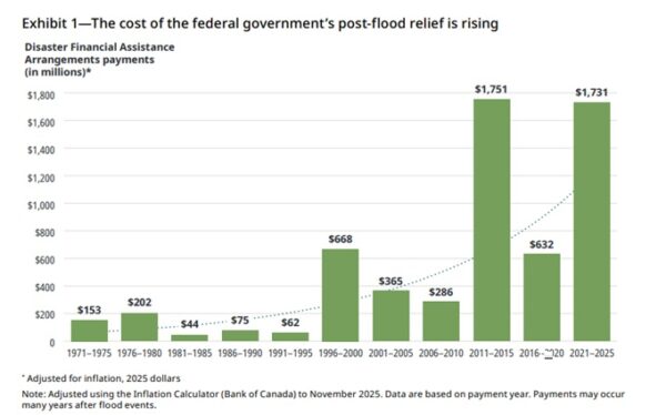
As climate change continues to accelerate faster than mitigation efforts, the Canadian Climate Institute estimates that flood-related damages in Canada could increase tenfold by the end of the century.
Why flood hazard mapping is challenging in Canada
Challenges in flood hazard mapping are a key reason why Canada has fallen behind in developing a comprehensive flood mapping system. I have listed down a few :
Decentralized Jurisdiction
The process of flood mapping in Canada is complex due to the distribution of responsibilities across federal, provincial, territorial, and municipal levels of government. Although the federal government contributes funding, conducts research, and establishes national frameworks, the primary responsibility for the creation and maintenance of flood maps resides with the provinces and territories.
Meanwhile, municipalities typically oversee local land-use planning and emergency management. This decentralized structure may result in inconsistent mapping standards, disparities in data sharing, and delays in the timely updating of flood maps across different jurisdictions.
Outdated Data
Many flood maps currently used across Canada rely on historical weather and hydrological data that may no longer reflect present-day climate realities. Numerous maps were created decades ago and do not account for the severity of increasing rainfall, urban development, land-use changes, or extreme weather events linked to climate change. As a result, some communities face greater flood risks than existing maps indicate, leaving residents and municipalities underprepared.
Public Resistance
Flood mapping can become politically and socially sensitive because of concerns about property values, insurance costs, and future development restrictions. Homeowners may fear that being identified within a floodplain could reduce the market value of their property or make insurance more expensive. These concerns have contributed to debates in provinces such as Nova Scotia and Quebec.
Lack of Commercial/Residential Integration
Flood mapping tools are frequently not completely incorporated into real estate deals, urban planning frameworks, mortgage evaluations, or public infrastructure development. Better integration of flood information into property disclosures, insurance processes, and city planning could enable communities to make more informed choices and enhance their resilience to climate impacts.
The Path Forward
After all the discussions, what should happen to make flood mapping successful and complete?
- A Standardized geospatial data framework can offer guidelines for data collection, which is essential for accurate flood mapping. These standard outlines best practices for project planning, data gathering, processing, validation, and the expected outputs. Geomatics standards can specify details related to inundation, flood hazards, flood risks, and flood awareness, helping to define the requirements for acquiring, managing, and distributing geospatial data.
- Enhanced and more efficient coordination between federal and provincial systems is necessary to prioritize flood mapping. This includes shared data systems and regular updates to flood maps that consider the impacts of climate change. Long-term funding organizations such as Natural Resources Canada and Environment and Climate Change Canada could collaborate more effectively with provinces, municipalities, and Indigenous communities to develop a practical flood mapping tool.
- Canada’s Collaborative Geospatial Strategy can bring together Canadian geospatial resources to improve the accuracy and accessibility of flood risk information by promoting better data sharing, consistent mapping standards, and the integration of climate change projections. This strategy supports the consolidation of Canadian geospatial assets, open data publication, and transparency.
Closing Remarks
Without updated and coordinated flood mapping, Canada risks falling behind in climate change preparedness. Delaying each year makes it harder to proactively protect homes, infrastructure, and communities from increasingly severe flooding events. Flood mapping is no longer just a planning tool — it is becoming a critical part of Canada’s climate adaptation strategy.


Be the first to comment