
- Satellite imagery highlights the impacts of Sudanese War on agriculture
- A resurgence in American satellite capability
- NASA-ISRO collaboration is measuring changes in places like Mexico City
- Taylor Geospatial and Microsoft partner to build first global agricultural field map
- Is AI undermining our trust in geospatial imagery?
- Geospatial AI helps to map illicit activities in the world’s rainforest
Satellite imagery highlights impacts of Sudanese War on agriculture
The outbreak of war between the Sudanese Armed Forces (SAF) and the paramilitary Rapid Support Force (RSF) have had a major impact on Sudan’s agricultural lands. With the help of imagery from Sentinel-2, Al Jazeera has mapped the impact of war on the agriculture lands of three central agricultural states in Sudan.
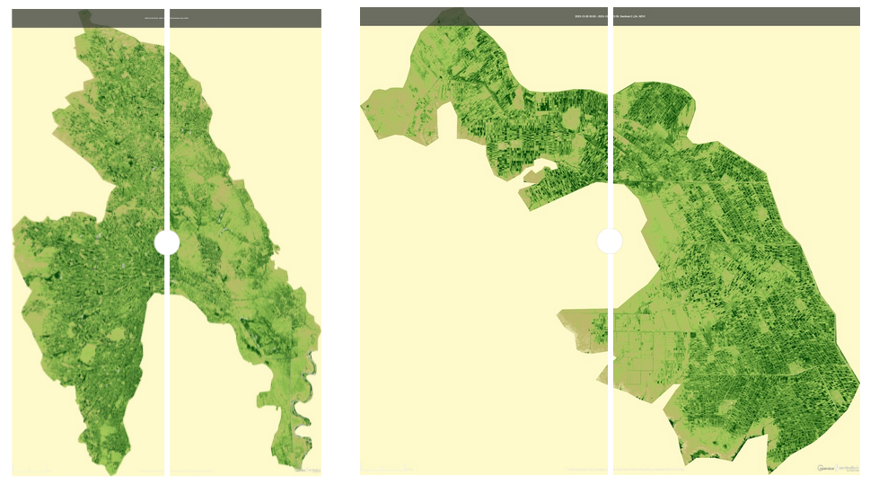
The data highlights extensive agricultural collapse in 2024, corresponding to occupation by the RSF. In 2025, the RAF recaptured most of this territory, which has since lead to minor, but fragile improvements in agricultural cover.
Learn more here:
A resurgence in American satellite capability
There has been a recent surge in satellite development throughout the San Francisco area, with at least 8 companies currently developing satellites for application in GNSS, communication and remote sensing. One of these firms is Basalt Space, which is developing a satellite network in which users can rent a constellation of 5 -15 satellites as a service.
This increase in satellite development is likely occurring due the influx of cheap, powerful satellite components, as well as the increased availability of satellite launches. There continues to be concern that a rapid increase in satellites will lead to an overcrowded sky and proliferation of space junk.
Learn more here:
NASA-ISRO collaboration is measuring changes in places like Mexico City
In 2025, NASA and the Indian Space Research Organization (ISRO) launched NASA-ISRO Synthetic Aperture Radar (NISAR), which tracks real-time changes across the Earth’s surface. NISAR is useful for measuring slow, subtle movements which can be found in large-scale phenomena such as melting glaciers or subsiding land.
One area of focus for NISAR has been Mexico City. Built on top of a large aquifer, Mexico City has been known to sinking for at least 100 years. NISAR measured the city between October 2025 and January 2026, finding that areas of the city are sinking by as much as several centimetres per month.
Learn more here:
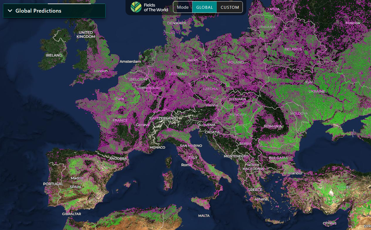
Taylor Geospatial and Microsoft partner to build first global agricultural field map
Taylor Geospatial and the Microsoft AI for Good Lab have partnered to build Fields of the World, the first map showing the location and extent of the world’s agricultural fields. Taylor Geospatial has partnered with with groups such as NASA Harvest and the UN Food and Agricultural Organization (FAO) to make their data available for food security analysis and climate change modelling.
Learn more here:
Is AI undermining our trust in geospatial imagery?
Since the start of the Iran War, there has been a wave of AI altered geospatial imagery of the conflict zone. There is a strong likelihood that AI fabricated imagery will only become more common, meaning we will have to reconsider the way we use geospatial imagery.
There are several ways in which we can increase the accuracy and truthfulness of our imagery. It is crucial to use data from reputable vendors with extensive metadata. Increasingly, the provenience of data will become vital and while AI makes it simple to fabricate or alter imagery, it will also help to improve our capacity for detecting fraud.
Read more here:
Geospatial AI helps to map illicit activities in the world’s rainforest
It is very challenging to monitor rainforests, as their size and remoteness make it difficult to track activities such as illegal mining and forestry. Increasingly, geospatial AI is helping to meet this challenge. The Pulitzer Center and Earth Genome have partnered to in support of journalists and the public by helping to track illicit activities in the world’s rainforests.
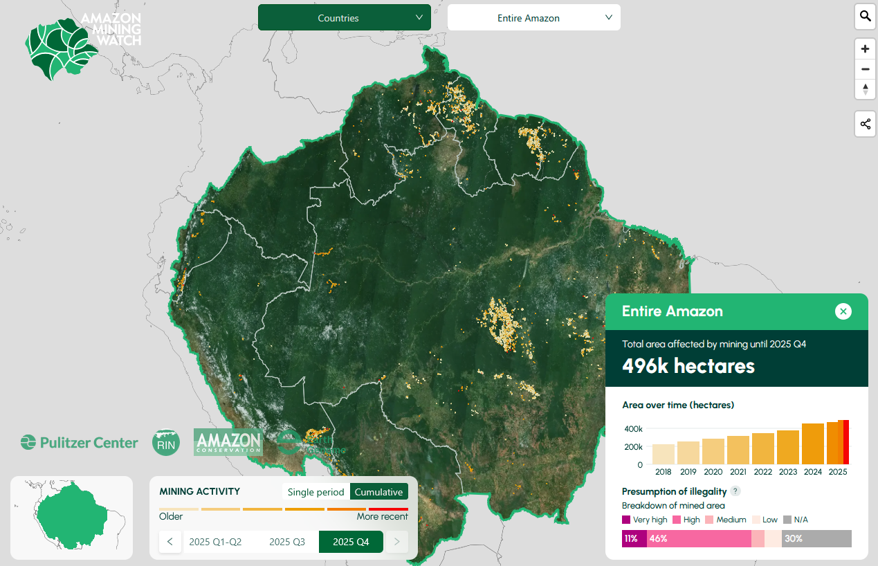
One of the ways in which they are are doing this is through Amazon Mining Watch, a web application tool that tracks mining sites across the Amazon Rainforest. Currently, the duo is working with an African partner to build Africa Mining Watch.
Read more here:


Be the first to comment