
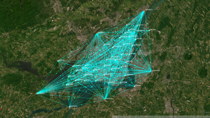
This is the fourth article in an ongoing series on the modernization of Canada’s spatial reference system. The series traces the transition from NAD83(CSRS) and CGVD28 to NATRF2022 and CGVD2013 v1, from foundational concepts through to real-world infrastructure impacts. This article presents a detailed municipal case study based on work carried out by the City of Montréal.
Ready, But Waiting
Somewhere in a municipal database in Montréal, a set of coordinates is sitting idle. Those coordinates describe 32 geodetic control points distributed across the island, computed in NATRF2022 and CGVD2013 v1, verified through months of fieldwork and rigorous post-processing. They are accurate. They are ready. But for now, they cannot be officially used.
This is not a story about technical failure. It is a story about what it actually takes for a municipality to prepare for Canada’s reference frame transition, and what happens when technical readiness runs ahead of the governance processes that must accompany it. Montréal has done the hard work. However, the official provincial transition has not yet occurred. And in that gap sits one of the most instructive case study available to Canadian municipalities preparing for the next generation of geodetic reference systems.
The previous article in this series examined what is at stake across Canada’s critical infrastructure sectors when reference frames shift. This article zooms in: one city, one island, one team, and the four-phase modernization program that brought Montréal’s geodetic network to the threshold of the new era.
Why Municipalities Need to Act Before the Official Transition
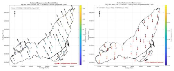
Quebec still operates in NAD83(CSRS) v2 epoch 1997 with CGVD28, one of the older reference frame realizations still in active use in Canada. That frame was well suited to the technology and workflows of its time. But it is increasingly misaligned with modern GNSS positioning workflows, where horizontal discrepancies between legacy and modern reference frames like NATRF2022 can exceed one metre across Montréal Island.
For day-to-day survey work, a metre-scale discrepancy between what a base station broadcasts and what a municipal geodetic database expects is not a theoretical concern. It is a practical problem that shows up in construction setouts, utility as-builts, infrastructure assessments, and any application where coordinates from different sources need to agree.
The national transition to NATRF2022 and CGVD2013 v1 will not happen at a single moment. It will arrive province by province, municipality by municipality, through a sequence of official publications and network adjustments that will take years to complete. Cities that wait for those announcements before assessing their own infrastructure will face compressed timelines, inadequate control networks, and staff who have never worked through a datum transformation in an operational setting. The lesson from Montréal is that preparation is not something you do when the deadline arrives. It is something you build toward, phase by phase, while the deadline is still years away.
Montréal’s Phased Approach to Geodetic Modernization
Montréal’s modernization effort is the work of Youssef Smadi, senior geodetic engineer leading the city’s geodetic assessment program. It did not begin with the passive network campaign described in this article. It is the product of a four-phase program developed over several years, each phase building the infrastructure and expertise that the next one required.
Earlier phases focused on developing a local geodetic database, known as the GeoSMART System (documented here), and on the active control network, including the development and integration of continuously operating reference stations with national systems. The Real-Time GNSS Network, powered by GNSMART software and documented in the article Pride in Precision: Montréal’s Real-Time GNSS Network and Its Legacy, was central to that work. Phase three, which is the subject of this case study, shifts attention to the passive geodetic network: the first-order geodetic control monuments that form the foundational layer of Montréal’s spatial reference infrastructure. Phase four, still ahead, will be the official transition to NATRF2022 once the provincial network adjustment is published.
The goal of phase three was specific and practical: assess the current state of the passive network, rebuild what had been lost, and compute coordinates for every surviving and reconstructed point in both the legacy systems the city currently uses and the modern frameworks it is preparing to adopt. The result would not be an immediate transition. It would be a foundation, ready to activate when the official provincial decision comes.
The Passive Network: Inspection, Loss, and Reconstruction
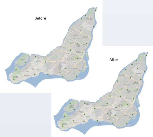
Montréal Island originally held a network of 28 passive first-order geodetic control points, classified under provincial A2 and A3 standards. These are physical monuments embedded in stable structures across the island, used as reference marks for surveys, engineering projects, and infrastructure management. Unlike active CORS stations, passive points do not broadcast a signal. They simply exist, reliably, at a known location with a known coordinate.
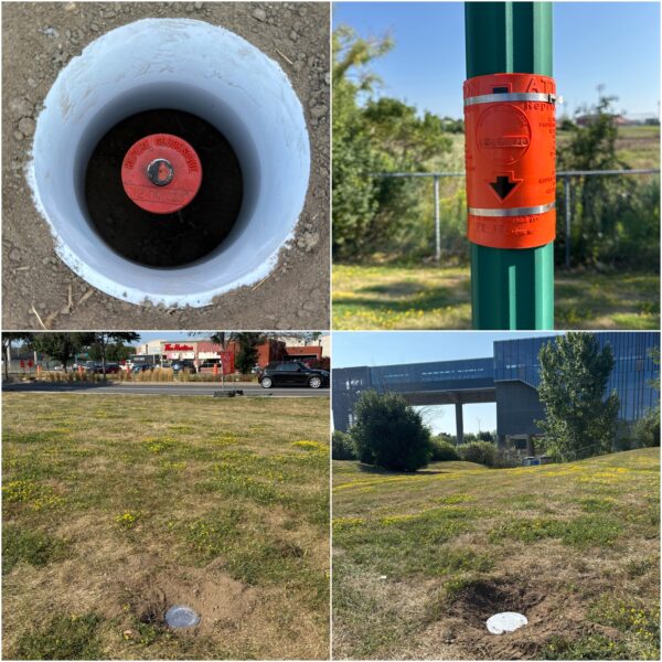
When the team began field inspections, they found that 19 of the 28 points were still in acceptable condition. Nine had disappeared or deteriorated to the point where they could no longer serve as reliable control. Urban development, construction activity, and the simple passage of time had done their work. A total of 13 new monuments had to be designed and installed to provincial geodetic specifications, a process that required evaluating underground accessibility and excavation constraints at each candidate location, securing budget, planning the installation, and coordinating access with city departments, before any GNSS campaign could begin.
This phase of the work is often invisible in discussions of reference frame modernization, which tend to focus on the computational and transformation challenges. But rebuilding a passive network is genuinely difficult. Installations were carried out in summer, given that the specialist contractors required do not operate in winter conditions. Each new monument required careful site selection, subsurface assessment, and formal coordination with the relevant city departments before a single piece of hardware went into the ground.
The GNSS Campaign: Six Weeks, Five Receivers, 1,400 Hours
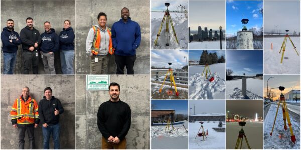
GNSS observations are inherently tied to the epoch at which they are collected and, in this project, were acquired using full GPS, GLONASS, Galileo, and BeiDou observations, potentially making this one of the largest municipal multi-constellation GNSS campaigns conducted in Canada. With the network rebuilt, all 32 points documented, and the planning of the GNSS sessions, logistics, and internal approvals completed, the observation campaign began in January and ran for six consecutive weeks through to February 10th.
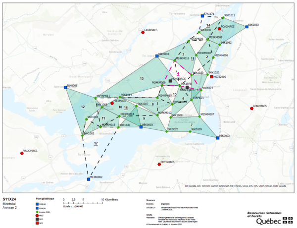
The campaign was intensive by design. Quebec’s provincial standards for geodetic GNSS observations require each point to be observed at two separate sessions, which means the full campaign involved 36 individual observation sessions across 18 network figures. Five GNSS receivers were deployed simultaneously on each figure, with each session lasting a minimum of two hours. Over the six-week period, the campaign accumulated approximately 1,400 hours of observation time and produced more than 2,000 baseline vectors for processing. Observations were referenced to the QACS (Quebec Active Control Station, 1 base station) and the MACS (Montreal Active Control Stations, 7 base stations). The official coordinates of the MACS in NATRF2022 and NAD83(CSRS) v8 epoch 2010 were estimated as part of the national CACS network, providing the framework connections needed for the subsequent adjustments.
The logistical demands of the campaign deserve mention. In January and February in Montréal, field teams were locating and clearing control points buried under snow before each session, marking them to ensure the receiver operators could find them quickly on observation day. Driving to the next scheduled point on a snowy day, with heavier than usual traffic, added its own layer of stress to an already demanding schedule. As project manager, Youssef worked through weekends to maintain the schedule and to process each week’s data before the next session began.
“One of the most valuable lessons from this project was the importance of staying ahead of the data. By validating, organizing, and processing the observations on a weekly basis following each GNSS static campaign, we were able to quickly identify inconsistencies and correct issues early. This proactive approach significantly reduced the time spent troubleshooting later, avoiding hours of head-scratching trying to understand problems from previous weeks.”
Youssef Smadi, City of Montréal
That discipline, processing weekly rather than batching everything at the end, proved to be one of the project’s most important operational decisions.
Processing Across Time: The Multi-Epoch Challenge
Post-processing the campaign data was technically the most complex part of the project, and it illustrates why reference frame modernization requires a level of expertise that goes well beyond conventional GNSS survey workflows.
The CODE precise ephemerides used to process the data were downloaded according to the campaign observation days and expressed in ITRF2020 at observation epoch 2026.1. NATRF2022 shares the same coordinates as ITRF2020 at reference epoch 2020. Quebec’s current operational system, NAD83(CSRS) v2, uses epoch 1997. To produce coordinates usable in each of those systems, the data had to be propagated through time using station velocities, plate motion models, and geoid models, not just converted through a static transformation.
“The real complexity of this project lies in the temporal dimension of geodesy. Working with modern GNSS means working within time-dependent reference frames. Transforming observations from ITRF2020 at the observation epoch into NAD83(CSRS) or NATRF2022, as well as computing heights in CGVD2013 v0a (epoch 2010) or CGVD2013 v1 (epoch 2020), is not merely a coordinate or height conversion. It is a propagation through time, driven by station velocities and plate motion and geoid models. This requires a level of rigor and expertise that goes well beyond traditional workflows. Through this work, Montréal is not only preparing for NATRF2022, but also building a new framework that we hope will serve as a reference for other municipalities across Canada.”
Youssef Smadi, City of Montréal
The transformation chain was managed using two NRCan tools: TRX_Beta for horizontal coordinate transformations across epochs and realizations, and GPS.H Beta for orthometric height computations under CGVD2013. The batch processing approach through TRX_Beta allowed the team to move the full dataset from ITRF2020 epoch 2026.1 back to NAD83(CSRS) v8 epochs 2010 & 1997, and back to NATRF2022 epoch 2020. Coordinates in v2 epoch 1997 were obtained by adjusting the baselines with recent MACS coordinates computed in collaboration with MRNF in the same reference frame and epoch. A parallel height processing stream produced elevations in CGVD2013 v0a (epoch 2010) and CGVD2013 v1 (epoch 2020), using the geoid model files CGG2013an83.byn and SGEOID2022v0beta_NA_n22.byn respectively in the adjustment software. It is worth noting that TRX_Beta and GPS.H Beta are pre-release tools made available by NRCan ahead of their official adoption, specifically to support users like Montréal in beginning their preparation for the transition to NATRF2022.
The resulting dataset gives the city adjusted coordinates for all 32 points in four systems: NAD83(CSRS) v2 epoch 1997 with CGVD28, NAD83(CSRS) v8 epoch 1997 with CGVD28, NAD83(CSRS) v8 epoch 2010 with CGVD2013 v0a, and NATRF2022 with CGVD2013 v1 (epoch 2020). Horizontal differences between the older NAD83 realizations were on the order of a few centimetres. The shift between legacy NAD83 systems and NATRF2022, however, exceeded one metre across the island, confirming the practical significance of the transition for any application requiring consistency between old and new coordinates. Vertically, the difference between CGVD28 and CGVD2013 was approximately 36 centimetres, with smaller differences observed between the two CGVD2013 model versions.
Ready But Waiting: The Provincial Dependency
Montréal is not a geodetically isolated city. Its base stations serve not only the island but the surrounding municipalities, including Laval to the north and communities like Châteauguay to the south. Those municipalities use the same reference infrastructure and currently operate, like the rest of Quebec, in NAD83(CSRS) v2 epoch 1997.
If Montréal were to update the coordinates of its base stations to NATRF2022 unilaterally, any surveyor from a neighboring municipality connecting to those stations would immediately encounter a discrepancy of approximately 1.2 metres against the points in their own geodetic database. That is not an acceptable operational outcome. The transition has to happen in coordination, and that coordination requires an official provincial decision.
The coordination mechanism is the province. Quebec’s Ministry must adjust the entire provincial geodetic network and publish the updated coordinates in Géodeq, the provincial geodetic and vertical control database, before any municipality can formally adopt the new system. Currently, every point in that database is still listed in v2 epoch 1997 with CGVD28. The provincial publication timeline is targeting approximately 2030, which means the city’s carefully computed NATRF2022 coordinates will sit ready in an internal database for several more years before they can be deployed operationally.
It is important not to understate the role of the provincial ministry in this process. The official network adjustment is not a formality. It is the mechanism that ensures all municipalities, large and small, transition together on a consistent and reliable foundation. Montréal’s preparation is valuable precisely because it positions the city to act decisively once that official decision comes, not because it replaces it.
The scope of what that official transition will trigger is worth appreciating. The shift to NATRF2022 extends well beyond GNSS processing and reference frame transformations. Cadastral systems, municipal databases, engineering records, and infrastructure datasets tied to the legacy reference frame will all need to be migrated to the new system. Achieving that transition will require time, coordination, education, preparation, software modernization, and training throughout the geomatics community. Software ecosystems must also evolve to fully integrate NATRF2022 and its associated transformations. This is a community-wide effort in which governments, software vendors, equipment manufacturers, and geomatics professionals must all contribute to ensuring that Canada is operationally ready by 2030.
What Other Municipalities Should Take From This
Montréal’s experience points to four areas where any municipality planning for the NATRF2022 transition should invest attention early.
First, inspect your passive control network before you need it. The state of passive monuments is rarely well documented, and the gap between what is recorded and what actually exists on the ground can be significant. Discovering that a third of your first-order points have disappeared is something you want to find out during a planned assessment, not during the final weeks before a provincial rollout.
Second, plan for a GNSS campaign that meets provincial standards, not just internal requirements. The Quebec standards that shaped the Montréal campaign, including dual-session observations and simultaneous multi-receiver deployment across multiple constellations, are demanding for good reason. High-quality input data is the only reliable foundation for high-quality coordinates in multiple reference frames.
Third, understand the multi-epoch transformation chain before you encounter it under time pressure. Moving data from an ITRF2020 at observation epoch 2026.1 into NAD83(CSRS) v8 (epoch 2010) or NATRF2022 involves tools, velocity models, and processing decisions that require hands-on familiarity. NRCan’s TRX_Beta and GPS.H Beta are available, but working through them for the first time on a production dataset is not the right approach. Build that competency now.
Fourth, get comfortable with what the datum shifts actually mean for your applications. A one-metre horizontal shift and approximately 36-centimetre vertical shift are not the same problem for all users. Understanding which of your workflows are sensitive to those magnitudes, and at what tolerance levels, will help you prioritize which systems need immediate attention when the transition arrives and which can be updated on a longer schedule.
Cities that have not started this work are not necessarily far behind, but the learning curve is real. Montréal spent roughly two years on phase three alone. The internal approvals, coordination with MRNF and NRCan, field campaigns, data processing, troubleshooting, and technical analysis all required significant time and effort.None of it happened quickly. Other municipalities should factor that timeline into their planning assumptions.
Building Canada’s Next Geodetic Era, One City at a Time
NRCan and the Canadian Geodetic Survey have done the foundational work. NATRF2022 and CGVD2013 v1 exist, the transformation tools are available, and the national framework is in place. What remains is the local layer, hundreds of municipal networks across the country that need to be assessed, rebuilt where necessary, and connected to the new system.
Montréal’s phase three project is one of the first completed examples of what that local preparation looks like in practice. It is technically demanding, institutionally complex, and logistically hard. It is also exactly the kind of work that needs to happen, city by city, before the national transition can be considered complete at the operational level.
The intent behind this case study, shared openly for the benefit of the broader geospatial community, is to give other municipalities a clearer picture of what they are preparing for. Not just the theory of reference frame modernization, but the reality of it: the summer installations, the winter fieldwork, the batch transformations, the governance dependencies, and the long wait between being ready and being permitted to act.
That picture is useful precisely because it is honest. Canada’s geodetic transition is not a software update. It is a sustained, coordinated effort that runs from the national framework all the way down to a monument in the ground on the south end of an island in the St. Lawrence. Montréal has shown one way to get that work done. The question for every other municipality is simply: when do you start?
Acknowledgements
Many thanks to Youssef Smadi for generously sharing his work and expertise, and for his openness in documenting this project as a resource for the broader geospatial community. Youssef would first like to acknowledge the leadership of the Geomatics Division at the City of Montréal for providing the authorization, resources, and personnel necessary to carry out this work. He would also like to extend his sincere thanks to Brian Donahue of the Canadian Geodetic Survey at Natural Resources Canada, whose continuous support over the past decade has been instrumental to Montréal’s geodetic modernization efforts, as well as to the Geodesy and Special Projects Service (SGPS) of the ministère des Ressources naturelles et des Forêts (MRNF) for their collaboration and ongoing support throughout the years.

Be the first to comment