
In the first and the second articles of this series, we explored what CSRS modernization is and why reference systems eventually need to change. The rationale for modernization was that measurement technology improves, systems age, and at some point the gap between the achievable accuracy of the technology and what can be supported by the system becomes too wide to ignore.
This article takes a different approach. Rather than continuing to explain the mechanics of modernization in the abstract, it examines a more direct question: what are the real-world impacts of reference system modernization, and what is at stake if we don’t act on them?
The answer, it turns out, touches nearly everything that keeps Canadian communities functioning. The CSRS is not a niche geodetic concern. It is the common positioning foundation shared by pipelines and power lines, flood maps and property boundaries, navigation systems and emergency response networks. Understanding what is changing – and what the stakes of that change are – matters well beyond the geomatics profession.
A Shared Reference, Hidden in Plain Sight
Most Canadians have never heard of the Canadian Spatial Reference System. That is precisely the point. A reference system works best when nobody notices it. It is the quiet agreement, encoded in thousands of datasets, instruments, and software packages, describing what coordinates mean and how heights are measured.
Every time a utility crew marks the location of a buried gas line, that record is referenced to the CSRS. Every time a municipal engineer designs a stormwater drainage system, the elevations are derived from Canada’s national vertical datum. Every time an emergency dispatcher routes responders to a GPS coordinate, that coordinate is meaningful only because there is a shared system underneath it.
This invisibility is a feature, not a flaw. But it also means that when the reference changes, the implications ripple outward in ways that are easy to underestimate from the outside.
The transition to NATRF2022 – the new geometric reference frame replacing NAD83(CSRS) – will introduce horizontal coordinate shifts of approximately one to two metres across Canada. The updated realization of the vertical datum will similarly adjust height values in some areas. Neither change alters anything physical on the ground. But they do alter the numerical values used to describe that ground, and for systems that were built on precise positional information, the implications require careful attention.
Pipelines, Power Lines, and the Tolerance Problem
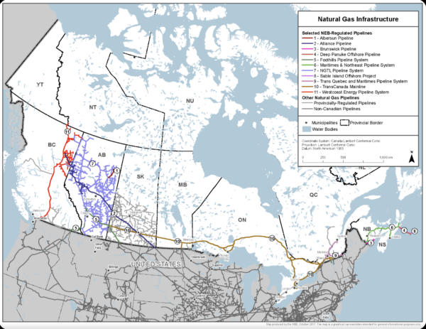
Canada’s energy infrastructure is among the most geographically extensive in the globe. Hundreds of thousands of kilometres of pipelines, transmission lines, and buried utilities crisscross the country. Where these assets are mapped and recorded, their coordinates are tied to the current reference system – though it is worth noting that significant portions of buried infrastructure remain incompletely documented, which adds its own layer of risk to any reference system transition.
For many routine applications, the one-to-two metre shift introduced by NATRF2022 falls comfortably within existing operational tolerances. A buried pipeline recorded with a positional uncertainty of several metres is not materially affected by a datum shift of comparable magnitude. The asset is still where it was; only the number describing it has changed.
But precision thresholds vary significantly across the sector. High-accuracy pipeline mapping for integrity management, encroachment detection, and regulatory compliance operates at much tighter tolerances. When field survey data collected in NATRF2022 is overlain on legacy records in NAD83(CSRS) without a proper transformation being applied, the resulting misalignment is not random noise – it is a systematic, predictable offset that will appear in the same direction for every asset in the dataset. That kind of consistent shift is the hardest to catch, because it can pass visual inspection and only reveal itself when discrepancies accumulate.
The oil and gas sector in Canada has long navigated complex datum environments – many northern and legacy datasets still reference NAD27, and practitioners have developed considerable expertise in managing these transitions. The addition of NATRF2022 is another layer of that complexity, but one that the industry is well positioned to manage if the transformation tools and metadata standards are in place and consistently applied.
Flood Mapping: Where Centimetres Have Consequences
Of all the applications that depend on the CSRS, flood mapping may be the one where vertical precision matters most directly to the safety of the public.
Floodplain boundaries are defined by elevation. A zone designated as the one-in-one-hundred-year flood extent is delineated at a specific height above a reference surface. Whether a property falls inside or outside that boundary – and therefore whether it faces development restrictions, insurance obligations, or evacuation protocols – can depend on differences of just a few centimetres of elevation.
The updated realization of Canada’s vertical datum, CGVD2013 v1, is based on the new GEOID2022 model, which incorporates substantially improved gravity data including new airborne surveys, higher-quality satellite observations, and contributions from U.S. and Mexican partners. In some regions, particularly where the original CGVD2013 realization had limited gravity data coverage, the new model will adjust height values in ways that could shift floodplain boundaries.
This is not a problem created by modernization. It is a problem that modernization is designed to reveal and correct. Flood maps built on a less accurate vertical reference are not more reliable simply because they pre-date the update. Improved height accuracy means improved delineation accuracy – and for communities already investing heavily in flood mapping infrastructure, the coincidence of datum modernization and the government’s $228-million Flood Hazard Identification and Mapping Program represents an opportunity to align these efforts rather than treat them as separate tracks.
Importantly, the tools that support this work are already being updated. NRCan has been working with major GIS platform providers including Esri and the open-source PROJ library to ensure that NATRF2022 and the updated vertical realization are supported within the software environments that flood mappers, cadastral professionals, and municipal GIS teams rely on. This means that for many users, the transition will be managed at the software level rather than requiring manual coordinate transformations.
Land Titles, Boundaries, and Legal Descriptions
Land surveying in Canada operates within a legal and regulatory framework that is deeply connected to reference systems. Survey plans, property boundaries, rights-of-way, and cadastral records are tied to specific datums, and in many provinces, the datum used for legal surveys is explicitly encoded in legislation and standards.
A NRCan Geomatics Canada open file published in 2024 documented the scope of this regulatory dependency. Survey responses collected across federal, provincial, and municipal stakeholders found that NAD83(CSRS), in its various versions, is the most widely used datum for property and infrastructure mapping across Canadian jurisdictions. In many cases, the specific version of NAD83(CSRS) in use is written into provincial survey acts, surveyors’ regulations, and municipal bylaws.
The survey results illustrate just how broadly the current reference system is embedded in regulatory and contractual frameworks across Canada. The following figures, drawn from the 2022 Regulatory Dependency Survey conducted as part of that report, show the number of respondents who identified datum dependencies within each regulatory category and sector:
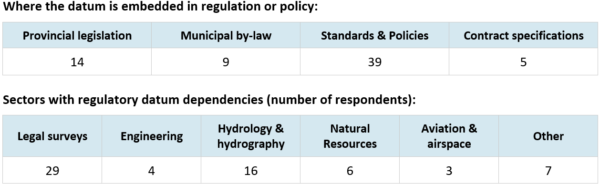
These numbers underscore a point that is easy to overlook: transitioning to NATRF2022 is not simply a matter of updating software or recalibrating instruments. For a significant portion of Canadian geospatial practice, it will also require working through regulatory and legislative channels to update the datum references embedded in law.
This creates a transition challenge that is as much administrative as it is technical. A survey conducted in NATRF2022 will produce coordinates that differ from an adjacent legacy survey by one to two metres. The physical boundary between those properties has not moved. But if the datum context is not clearly documented and the transformation correctly applied, the numerical records will appear to disagree, which can create complications for title searches, subdivision approvals, and boundary dispute resolution.
For Indigenous land rights, treaty boundaries, and reserve surveying, the stakes are compounded further. Treaty maps and land claim boundaries established under earlier reference systems are legal instruments. Any update to the reference system must be accompanied by clear transformation procedures and, in many cases, formal processes involving the parties to those agreements. This is not a minor footnote to modernization – it is one of the most sensitive transition dimensions the system must navigate.
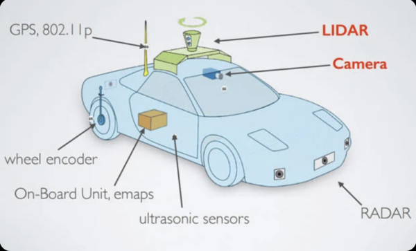
Navigation, Autonomous Systems, and the Demand for Accuracy
The arrival of NATRF2022 coincides with a period in which the demand for precise, reliable positioning has never been higher. Applications that were science-fiction a generation ago – autonomous vehicles, precision drone operations, real-time infrastructure monitoring – depend on a geodetic foundation that is both accurate and internally consistent.
One of the design weaknesses of NAD83 is that its origin is offset from the Earth’s true centre of mass by approximately 2.2 metres. For a GPS receiver trying to compute its position using signals from satellites that orbit in a geocentric frame, this offset introduces a systematic error that must be absorbed somewhere in the system. NATRF2022 eliminates this offset, aligning Canada’s reference system with the International Terrestrial Reference Frame of 2020.
For navigation applications, this alignment matters directly. For a vehicle guidance system, a drone, or a machine-control platform to operate safely, the map it navigates by and the positioning signal it receives must reference the same underlying framework. When they do not, even a predictable, systematic offset introduces risk. Ideally the system upon which the maps are based matches directly with the navigation system to minimize the possibility of error – and this is precisely what NATRF2022 makes possible.
Lane-level vehicle guidance, precision approaches for unmanned aerial systems, and real-time machine control for construction all require that the coordinate system underpinning GNSS corrections be as close to the physical truth as possible. The 2.2-metre NAD83 origin offset, while manageable in many traditional applications, becomes a design liability as positioning demands tighten.
Major GNSS correction service providers and equipment manufacturers are already in the process of updating their systems. Companies like Trimble have been working directly with NRCan and the U.S. National Geodetic Survey to build NATRF2022 support into firmware and software well ahead of the formal 2027 federal adoption. The transition in the navigation and precision positioning sector is, in many respects, already underway.
The Canada–U.S. Border: Why Timing Matters
One dimension of the CSRS modernization that is sometimes underappreciated is the degree to which it was driven by geography as much as by science.
Canada and the United States share one of the longest international borders on Earth. For over a century, the two countries have maintained compatible geodetic reference systems through close collaboration between the Canadian Geodetic Survey and the U.S. National Geodetic Survey. That compatibility is not a courtesy – it is an operational necessity for cross-border construction (e.g., bridges and pipelines), transportation networks, water management, emergency response coordination, environmental monitoring, and trade.
When the United States announced its plan to replace NAD83 with NATRF2022, it created an immediate problem for Canada. If Canada did not follow, the two countries’ reference frames would diverge by 1.3 to 1.5 metres along the shared border – a gap larger than any that has ever existed between the two systems. Cross-border datasets, shared positioning networks, and integrated operational systems would all face systematic misalignment with no simple fix.
This context reframes the modernization as not just a domestic technical exercise, but a national interoperability decision. Canada’s choice to adopt NATRF2022 in parallel with the U.S. – with federal adoption planned for early 2027 – reflects this reality. The coordination has been deliberate: CGS and NGS jointly developed the Euler pole parameters defining NATRF2022, and both countries are working toward the same geoid model for their vertical systems.
The Municipal Layer: Where Complexity Concentrates
If there is a single level of government where the practical complexity of CSRS modernization concentrates most sharply, it is the municipal level.
Municipalities are responsible for an enormous range of geospatial systems: base mapping, utility records, road centreline networks, stormwater and drainage models, building permit files, land use plans, emergency response layers, and more. These systems have typically been built over decades, and they do not all share the same reference frame. In some cities, different municipal departments are operating in different versions of NAD83 – not by choice, but because datasets were acquired at different times under different provincial or federal standards.
NRCan’s own documentation on the regulatory dependency of reference frames noted that the current patchwork of adopted versions already creates decimeter-level discrepancies at jurisdictional boundaries, and that this “requires significant expertise and effort to accommodate.” With the introduction of NATRF2022 bringing metre-level offsets from NAD83, the potential for confusion compounds significantly if transitions are not well coordinated.
The flip side of this challenge is that modernization also presents an opportunity. Moving to a unified national standard under NATRF2022 – which provinces and territories are expected to adopt by 2030 – offers municipalities a path to finally resolving some of the legacy inconsistencies that have accumulated over decades. The transition is a one-time disruption, but the outcome is a more coherent, maintainable, and interoperable spatial data environment.
That potential is not automatic. It requires coordinated planning, clear timelines from provincial geodetic authorities, and tools that make data migration manageable. The NRCan Geomatics Canada report found broad agreement among stakeholders that unified national adoption is the right goal, even as concerns about resources and capacity were consistently raised.
What the Transition Actually Looks Like
It is worth being direct about what is and is not changing for most practitioners.
Field practices are not changing. How measurements are collected in the field remains the same. GNSS receivers, total stations, and levelling instruments operate the same way in NATRF2022 as they do in NAD83(CSRS). The transition is in how results are expressed and related to existing data, not in how they are gathered.
Existing data is not becoming invalid. Decades of spatial data collected under NAD83(CSRS) remains usable. NRCan is providing defined transformation parameters between the old and new systems, and CGS tools such as the TRX desktop application already offer beta support for NATRF2022 transformations. The goal is that, over time, many of these conversions will be handled automatically within software pipelines.
The transition will be phased and parallel. Federal adoption is planned for early 2027. Provincial and territorial adoption is expected by 2030. During the transition period, NAD83(CSRS) and NATRF2022 will coexist, with tools and guidance supporting users in managing the relationship between them. This is not a hard cutover – it is a managed transition with an extended runway.
The most critical requirement through this period is metadata discipline: every dataset, every survey, every derived product must clearly document which reference system and which epoch it belongs to. The one-to-two metre shift between NAD83(CSRS) and NATRF2022 is entirely manageable as long as both sides of any data relationship are correctly labelled. It becomes a source of error only when that labelling is absent, ignored, or incorrect.
Looking Ahead
The CSRS is easy to take for granted precisely because it works. But the infrastructure that depends on it – the flood maps, the pipeline records, the property boundaries, the navigation systems, the emergency response networks – is not abstract. It is the spatial fabric of Canadian communities.
Modernizing the reference system that underlies all of that infrastructure is a significant undertaking. It requires coordination across levels of government, sectors, and disciplines that do not always speak the same language. What makes the work tractable is that it is planned, phased, and supported by tools designed specifically to ease the transition.
What makes it urgent is that the window to prepare is open now. The federal adoption milestone is less than a year away. Organizations that begin reviewing their reference system dependencies today will be far better positioned than those that encounter the shift as a surprise.
The next article in this series moves from the national picture to the local one – examining how one Canadian municipality has already begun navigating this transition, and what their experience reveals about both the challenges and the opportunities that modernization brings.
For official specifications, transformation tools, and implementation guidance related to CSRS modernization, consult the Canadian Geodetic Survey at Natural Resources Canada here


Be the first to comment