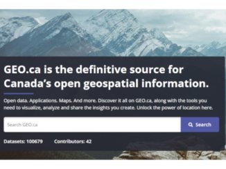
• facebook
  • Twitter
  • Linkedin
  • Youtube
  • Linkedin Group
  • Post a Job
  • Post an Ad
  • Post an Event
  • Post a Directory Listing
  • Post a Press Release
  • Media Kit
  • My Account
  • Login
GoGeomatics
  • MAGAZINE
    • BIM & GIS
    • Community
    • Conference news
    • Earth Observation
    • Education & Careers
    • GEOAI
    • Announcements
    • Reality Capture & Lidar
    • Science
    • Technology
  • Directories
    • ASSOCIATION
    • INDUSTRY
    • EDUCATION
    • Open Data
  • EVENTS
    • GeoIgnite Events
    • Events Calendar
    • GoGeomatics Meetups
  • Services
    • Advertising
    • Marketing
    • Post a Job
    • Post an Ad
    • Post an Event
    • Post a Press Release
    • Post a Directory Listing
    • Media Kit
    • Web Design
  • Find a Job
  • Volunteer
    • Start a GoGeomatics Group
    • Editors & Writers Group
  • About Us
    • About Us
    • Contact Us
    • Frequently Asked Questions
  • Videos
HomeOpen data

Open data

Earth Observation

National Elevation Data Strategy: A Decade of Innovation and Progress

27 November 2025 David Belanger | Building Footprints Automatically Extracted Buildings ArcticDEM

In 2015, Natural Resources Canada (NRCan) launched the National Elevation Data Strategy (NEDS), a bold initiative to modernize Canada’s landmass data foundation. Ten years later, the NEDS has become a cornerstone of Canada’s geospatial ecosystem, delivering […]

Tracey Lauriault
BIM & GIS

“Before It’s Too Late”: Tracey Lauriault on Canada’s Data Sovereignty Crisis

9 October 2025 Anusuya Datta | Artificial Intelligence

Digital sovereignty has quickly become one of the most pressing policy issues in Canada. From the U.S. Patriot Act and Cloud Act to the risks of foreign ownership of critical infrastructure, Canada finds itself increasingly […]

Chris Robson Wyvern
Earth Observation

Wyvern’s Chris Robson on Hyperspectral Leadership, Global Ambitions, and the Challenge of Building in Canada

1 September 2025 Anusuya Datta | AI

This interview is part of our GoGeomatics series on Canada’s infrastructure moment and its impact on the geospatial/Earth Observation industry. Canadian startup Wyvern is carving out a leadership position in high-resolution hyperspectral imaging with a […]

Community

Canada’s National Geomatics Awards 2025: Cast Your Vote

18 August 2025 GoGeomatics Canada | business

Earlier this year, we invited Canada’s geomatics and geospatial community to nominate the individuals and organizations making a real difference in our sector. Now it’s time to make the final call for the Canada’s National […]

Earth Observation

Revolutionizing Earth Observation with Google AlphaEarth AI

11 August 2025 Alefiya Dungrawala | AI

“Today we’re launching a new AI model, AlphaEarth Foundations, to help understand our planet in magnificent detail,” Google announced. In recent years, monitoring Earth’s landscapes has become increasingly crucial for tackling global issues like food security, […]

BIM & GIS

Solving Parking Puzzles in Waterloo using GIS

4 July 2025 Alefiya Dungrawala | bicycle parking

Where Do I Even Park? If you’ve ever driven through Uptown Waterloo, Ontario or near the University of Waterloo campus, you know the struggle — circling for parking, reading confusing signs, or landing in lots […]

Earth Observation

After Landsat 7: Honouring a Legacy, Continuing the Mission

15 June 2025 Benedicta Antwi Boasiako | agriculture

Every pixel tells a story. On June 4, 2025, Landsat 7 was officially decommissioned, closing out a mission that spanned more than two decades. Launched in 1999, Landsat 7 carried the Enhanced Thematic Mapper Plus […]

Conference news

The Canadian Hydrospatial Network: A Living System for Surface Water Intelligence

29 May 2025 Kruti Mehta | AI hydrology

The Canadian Hydrospatial Network isn’t just a technical upgrade — it’s a reimagining of how Canada models, manages, and mobilizes its water data. In her GeoIgnite 2025 presentation, Colleen Fuss, Physical Science Specialist (Geomatics) and […]

Posts pagination

1 2 … 12 »

Events

Notice
There are no upcoming events.

View All Events

Services

  • Post a Job
  • Post an Ad
  • Post an Event
  • Post a Directory Listing
  • Post a Press Release
  • Media Kit
  • My Account
  • Login

Jobs

Post a Job
  • Canada Maps and Poster Gallery Volunteer Leads — GeoIgnite 2026
    remote
  • GIS & Data Analytics Lead
    Beaumont, AB
  • Lead Surveyor, Projects/Arpenteur-géomètre principal, projets; arpenteuse-géomètre principale, projets
    North Bay, Thunder Bay
  • Senior GIS Developer
    Calgary, AB
View All Jobs
  • Directories
    • Associations Directory
    • Industry Directory
    • Education Programs
    • Open Data
  • Volunteer
    • Start a GoGeomatics Group
    • Editors & Writers Group
  • About Us
    • GoGeomatics Media Kit
    • Who We Are
    • Contact Us
    • FAQ’s
    • Advertising
    • Marketing
  • Subscribe
GoGeomatics
GoGeomatics is the largest and most popular communications hub promoting the Canadian geospatial community. The business was incorporated in 2011. GoGeomatics hosts over 100 fun, free, location technology networking events each year in cities across Canada.

© 2025 GoGeomatics

  • facebook
  • Twitter
  • Linkedin
  • Youtube
  • Linkedin Group