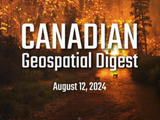
parks Canada

Canadian Geospatial Digest for August 15, 2022

Apple Maps is Coming to Your City this Summer, Satellites show World’s Largest Beaver Dam, Who lives in Canada’s Hottest…

A Canadian Geographer’s Notes from Nunavut

For the last five years, I have annually had the opportunity to spend time in Iqaluit, Canada’s fastest growing community in Canada’s fastest growing territory or province. On arrival, I check out the selection of new books at Arctic Ventures and the screening of new movies about the North. This year, there was the chance to see John Walker’s Passage and to buy a copy of Darrel Varga’s book of the same name in the Canadian Cinema series.

Marine Geomatics Primer: Using UUVs to Take Flight Underwater

Unmanned Underwater Vehicles One of the most interesting things to happen in regards to marine geomatics technology has been the…

Remembering Roger Tomlinson & Early History of GIS in Canada

It’s two years now since Roger Tomlinson passed away.  Roger’s and my career path have crossed several times over the…

Geomatics: Discovering history in Canada’s Arctic waters

This article was reprinted with permission from the Ontario Professional Surveyor, Volume 56, No. 3, Summer 2015 By Theresa Nicholsi,…

GIS: Parks Canada Receives Award for Enterprise Approach to Data Management

OTTAWA, Esri Canada User Conference – October 6, 2015 – Parks Canada fosters public understanding, appreciation and enjoyment of Canada’s…

Story Mapping: Haida Gwaii

In my previous blog “Storytelling: Haida Gwaii,” I referenced the Geomatics Association of Nova Scotia’s (GANS) mentoring program between myself…

Storytelling: Haida Gwaii

Haida Gwaii is a rich source for stories. There are many perspectives and many different formats. In the Haida culture…

Government of Canada Unveils 3D Model of HMS Erebus

Data collected by the Department of Fisheries and Oceans’ Canadian Hydrographic Service used to develop models of HMS Erebus FREDERICTON,…

Island Geography: Haida Gwaii

Canada, with its endless coastline, has thousands of islands. Besides the physical islands with tangible, defined boundaries, there are also…

GIS Technology and the Franklin Expedition: An Opportunity for Our Geomatics Sector

It’s taken nearly 170 years to uncover wreckage from the infamous Franklin Expedition, one of Canada’s biggest mysteries. Last week,…